Top 10 Most Beautiful Sustainable Landscapes in Europe

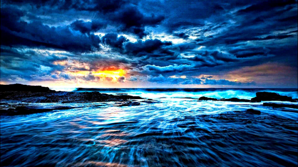
Europe is a breathtakingly diverse area, ranging from Norwegian islands well above the Arctic Circle to forest-covered highlands in Romania, windswept sandy ... read more...beaches in Wales, and frozen lakes in the Balkans. The historic towns and Mediterranean beaches of the old continent attract many visitors, but the finest places are frequently its most distant areas, known only to locals and a few daring travelers. In a world where vehicles, power wires, satellite antennas, and buildings have altered the landscape, come to recharge your batteries in environmentally friendly vacation places. Discover Europe's most stunning sustainable landscapes.
-
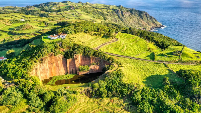
Santa Maria, the Azores' Sunshine Island, gained its moniker from being one of the hottest and driest islands in the archipelago, as it is the Azores' most southern island. This island was the first to be found by explorers and created, making it extremely unique. Santa Maria, along with So Miguel, is part of the Azores' Eastern Group. Santa Maria is unusual from the other islands, having yellow beaches and even a "red desert". Santa Maria is an island not to be missed, from touring the town center Vila do Porto to bathing in some of the nicest natural pools in the Azores.
Santa Maria is well-known for its stunning white sand beaches and is a haven for nature lovers, breathtaking scenery, leisure and relaxation, as well as surfing, sailing, windsurfing, paragliding, and diving. Don't forget to spend a day relaxing on the famed Praia Formosa, a magnificent white sandy beach that is rather uncommon in the Azores.
Wear excellent shoes and head out to visit the Santa Maria lighthouse if you want to be immersed in nature, peaceful, and see breathtaking scenery. "Farol de Gonçalo Velho" is one of Europe's most magnificent lighthouses, with breathtaking vistas. Come on a Wednesday if you want to see the lighthouse (otherwise it is open by appointment). It is one of several 100% natural settings that will leave you with memories to last a lifetime.
Location: Island in the Azores, Portugal
secretsfromportugal.com 
secretsfromportugal.com -
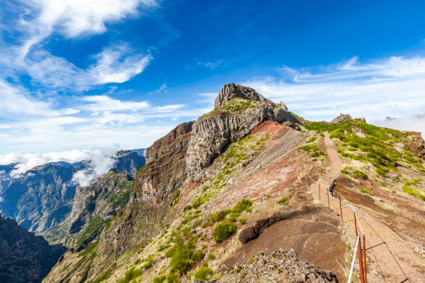
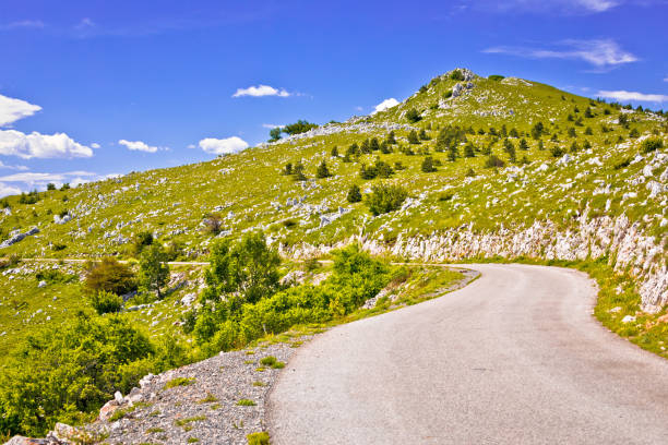
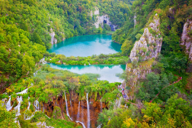
Triglav National Park is Slovenia's sole national park. It was founded in its contemporary form in 1981 and is located in the country's northwestern corner, namely in the southeastern section of the Alpine range. Mount Triglav, the tallest mountain in the Julian Alps, is virtually in the center of the park. The valleys radiate from it, delivering water to two enormous river systems that originate in the Julian Alps: the Soa and the Sava, which run to the Adriatic and Black Seas, respectively.
The Triglav National Park is Slovenia's oldest, largest, and only national park. Bohinj is in the center of it all. Triglav, Slovenia's tallest peak, is surrounded by a protected natural and cultural region. Because of the park's delicate natural habitat and fragility, it is also a member of Unesco's Man and the Biosphere Programme. Vintgar Canyon is a 1600-meter-long, 250-meter-deep gorge in Triglav National Park's eastern region. The Radovna river runs through the Vintgar gorge, which is filled with minor waterfalls, rapids, and erosion craters. The gorge may be visited through a safe tourist path that runs through it. Book your flights to Ljubljana, as well as your accommodation, excursions, and activities in Slovenia, such as a Bled and Bohinj Alpine Lakes trip from Ljubljana.
Location: Bohinj, Slovenia
istockphoto 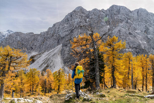
istockphoto -
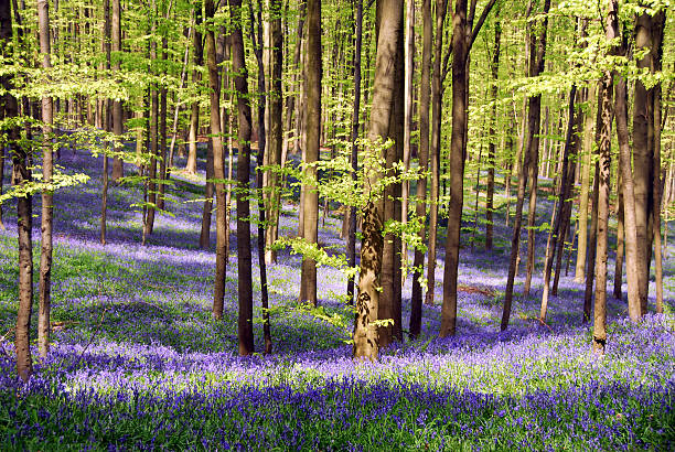
Thousands of people go to a forest just outside Brussels every spring to experience a stunning natural sight. It's the change of the Hallerbos from a green to a blue sea. For a view of the blue bells in bloom, avoid the busy Bois des Halles in Brussels. Discover this amazing spring display in Silly, a European Commission-awarded sustainable tourist destination. It's an experience not to be missed. It's amazing, captivating, and lovely... Words cannot do it justice: you must see them for yourself. If you go on a hot sunny day, the delicious aroma will draw you in long before you see the first bluebell.
When are the best months to see bluebells? That is what everyone is curious about. You don't want to go too early and see only leaves, or too late and see only dead heads. A good starting point is around the middle of April. However, the exact blossoming season varies according on the weather. If late March is unusually warm, they might arrive in early April. If March is chilly, then the end of April is more likely. Silly is a town in Western Belgium's Wallonie Picarde region. The municipality is made up of eight villages located halfway between Lille and Brussels. Bassilly, Fouleng, Gondregnies, Graty, Hellebecq, Hoves, Silly and Thoricourt offer a wide range of unknown riches on their 6768 Ha, of which 80% are cultivated and 8% are wooded. 70km of marked pedestrian trails and the brand-new network of cycle, guide amateurs to the discovery of 6 castles hidden in parks full of remarkable trees, churches, chapels, typical old houses and imposing old farms.
Location: Belgium
istockphoto 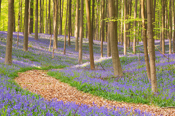
istockphoto -
Neamţ County, located in the north-east of Romania, has geographically diversified landscapes with distinct flora and fauna that are in perfect harmony with the natural and spiritual essence of its communities. It is comparable to an excellent outdoor museum, with numerous gorgeous locations, historical landmarks, and important artistic legacy. On the area of Neamţ County there are three national parks and five lakes, the largest of which -Izvoru Muntelui Lake- having 35 km long and being dubbed "the sea between the mountains". The growth of human settlements in this region resulted in the formation of Europe's brightest ancient civilisation, to which the Precucuteni-Cucuteni-Tripolie Complex, formed between 4200 and 2600 BC and including precious exhibits, belongs.
There is no other county in Romania that has such a rich spiritual life as Neamţ County. Many prayers have been raised to heaven from our lovely region over the years. Villages in the Neamţ area are true hearths where religion has never gone away, scattered amid the vastness of the highlands or buried in the dense forests, in tranquil clearings and in lovely valleys. Another distinctive feature of Neamţ County is the Ceahlău Massif, which is known as the Holy Mountain of Romanians and is a gorgeous site steeped in mystery and mysticism. Ceahlău Massif holds its Dedication Day on August 6th, when Christians throughout the world commemorate the Transfiguration of Jesus Christ, with stunning vistas along each of the eight defined routes.
Every year on August 6th, travelers may witness a world-famous phenomenon: the Shadow of the Pyramid. The phenomenon reaches its peak on August 6th at sunrise, when the shadow of Toaca Peak overlaps over the shadow of Piatra Ciobanului Peak, forming a natural hologram resembling a flawless pyramid that can be viewed for more than 80 minutes. Some researchers claim that one of the world's energy meridians runs through Toaca Peak (1904 m). Ceahlău Massif is therefore a tourist destination on par with Stonehenge or the Egyptian pyramids.
Location: Romania
istockphoto 
istockphoto -
The Mostviertel is located in the heart of scenic Lower Austria, between the Danube and Mt. Tscher. The plains and hills in the region's north are soft, and the farms and meadows are fruitful. This section of the Mostviertel is ideal for cycling and walking - simply enjoy and relax. Things are getting more daring in the south, where it is alpine and mountainous. A vacation in this portion of the region provides a lot of fun and excitement. But there is one element that unifies the north and the south: the open and welcoming nature of the people who live there.
Immerse your roots in the soil of Mostviertel and open your eyes and nose to view and breathe the sight of pear blooms in unspoilt nature. Mostviertel's pear trees are in blossom between April and May. You may also sample local and organic items created from orchard pears. People have committed their hearts and souls to the manufacture of perry, or pear cider, in the western portion of the Mostviertel, where the terrain resembles a big garden. This distinguishes them from other cider-growing regions in Europe, where apples predominate. A profusion of diverse pear kinds ripens on several hundred thousand gnarled pear trees in the region surrounding the 200-kilometer-long Moststraße, aided by the warm environment south of the Danube.
Location: Austria
istockphoto 
istockphoto -
Consider an island. The Azores' second biggest island. Pico is a volcano that is both gorgeous and eerie. Men have accomplished amazing things on this strip of land that arose some millennia ago under the urge of nature in the middle of the Pacific Ocean. They erected volcanic stone walls to shield the plants from the saline breeze and imported dirt to plant grapes, all while respecting the land and environment. They have now been creating their own wine for generations of brave and adventurous women and men.
This uncommon beauty of an island is a real gift from nature. It is one of the gems of sustainable tourism, located between the islands of Faial and Sao Jorge, and represents the coexistence of man and environment. Pico is an excellent destination for recharging your batteries, reconnecting with nature, meeting people, tasting their products, walking about the island, or hiking to the peak of the volcano. You will not see another environment like this in Europe, so don't delay in planning your sustainable tourism holiday at one of Europe's top ecotourism sites. Do you need another incentive to learn about Pico? At the base of this majestic volcano, you can find incredible underground tunnels produced by lava flows.
Location: Central Group of the Portuguese Azores, Portugal
istockphoto 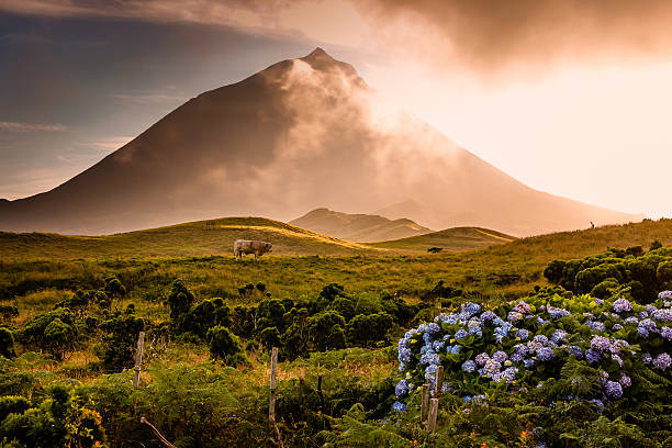
istockphoto -
The Caldeira Volcano is the island of Faial's tallest peak, greatest stratovolcano, and largest geomorphological feature. It is a two-kilometer-wide and 400-meter-deep volcanic cone in the center of the island. It is designated as a natural reserve and is home to unique indigenous flora species. The Caldeira, the island's genetic emblem, is a magnificent caldera due to its vastness and abundance of flowers, plants, and trees that gleam in the sunlight.
The principal geomorphological unit is the Caldeira Volcano, which is a polygenetic volcano two kilometers high and one kilometer deep. The crater rim's walls are sharp, albeit their slopes improve with height. The volcano's surface is coated in pyroclastic debris, including pumice rock, phreaatic and phreatomagmatic deposits, and signs of pyroclastic flows and lahars. The stratovolcano's sides also feature the Morro de Castelo Branco and a peninsula of denser material that has withstood erosion. Plants such as beech trees, junipers, moss, cedars, ferns, and hydrangeas adorn the 7-kilometer-long walls. At the bottom, 450 meters below the Caldeira overlook, a broken lake and a tiny volcanic cone dot the landscape, with remnants of the primitive laurissilva forest. Book your flights to Faial, as well as your top excursions and activities in The Azores, such as a whales and volcanoes tour with lunch, at the greatest price.
Location: Faial, Azores, Portugal
istockphoto 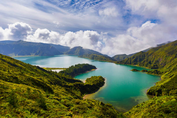
istockphoto -
Aerial image of Northern Velebit National Park Croatia shows whitish gray cliffs and pointed summits carpeted by green velvety forest areas and towering pine trees. These summits are snow-capped in the winter. And when you get up close, standing on the ground and staring up at these gigantic treasures, you'll understand why Croatia is known as a natural paradise. Northern Velebit National Park is the most recent of Croatia's eight major national parks, although it is far from the last in terms of spectacular scenery and exciting activities. Northern Velebit National Park, like all national parks in the country, has excellent fauna.
Perhaps the most distinguishing feature of this park in comparison to the others is that it is best suited for individuals who are not very fond of summer nature excursions. It is the only park where you can enjoy yourself even on frigid winter days because the mountains change into huge, white-tipped chocolate kisses. Skiing and other winter sports are popular in Risnjak National Park, while Northern Velebit National Park rates higher among Croatian winter attractions. Of course, visiting the park during the regular spring and summer seasons is also rewarding. It's wonderful that the park doesn't lose its radiance over the winter.
Northern Velebit National Park is located in Croatia's biggest mountain range, the Velebit range. This enormous mountain range spans over 100 kilometers from Senj to Zadar and encompasses around 2,000 square kilometers. Another national park inside this range is the Paklenica National Park. Despite being in a comparable region, Northern Velebit National Park Croatia has something completely distinct to offer.
Location: Croatia
istockphoto 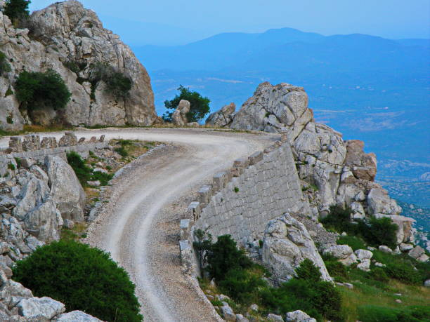
istockphoto -
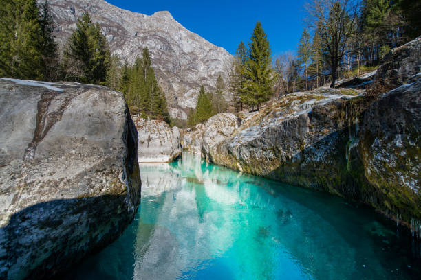
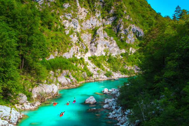
The lovely Soa river, which runs near the Italian border at the foot of the Julian Alps, has cut a thrilling valley and contains some of Europe's most stunning waters. The Tolmin Gorges are the Triglav National Park's lowest and southernmost access point. The lovely Soa river, which runs near the Italian border at the foot of the Julian Alps, has cut a thrilling valley and contains some of Europe's most stunning waters. The Tolmin Gorges are the Triglav National Park's lowest and southernmost access point.
The Velebit range, Croatia's largest mountain range, is home to the Northern Velebit National Park. This massive mountain range stretches over 100 kilometers from Senj to Zadar and covers around 2,000 square kilometers. Paklenica National Park is another national park inside this range. Northern Velebit National Park Croatia, while being in a similar location, has something absolutely unique to offer. The Bear's Head wedged rock and the Devil's Bridge are the most noteworthy sights. The beautiful Kozjak Waterfall is set in a rocky amphitheatre not far from Kobarid. It is accessible through an easy walking trail along the riverbed of the green Soa River. The Nadia River built up basins and gorges while also depositing several shingle beaches. It is one of the cleanest and warmest Alpine rivers.
Location: Slovenia
istockphoto 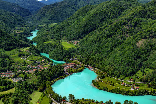
istockphoto -
Krka National Park stretches for 73 kilometers along the Krka River, from the Adriatic at Ibenik inland to the highlands of Croatia's interior. It's a spectacular site of waterfalls and gorges, with the river pouring through a 200-meter-deep karstic canyon. Human-made sights are also a big lure of the region, with the area's isolation attracting monks who established monasteries here. The Krka National Park is located in Southern Europe (Mediterranean and sub-Mediterranean). Because of its unique location and the mosaic distribution of many types of habitats, it has an extraordinarily rich and diverse flora and fauna.
There are various points of interest in the Krka National Park. There are several pathways, sightseeing tours and presentations, boat cruises, gift stores, a museum, and restaurants accessible. There are also some archeological relics of unpreserved strongholds going back to Roman times in the park's surroundings. uevo, Neven, Bogoin, Kljuica, and Burnum are their names.
Skradinski buk is one of the park's most appealing features. It's a huge, clear natural pool with big waterfalls on one end and cascades on the other. It is the lowest of three waterfalls generated by the Krka river. There are 17 waterfalls in an area 400 m long and 100 m wide, with a total height variation of 47.7 m between the first and last falls. Skradinski buk is regarded as one of Europe's most beautiful calcium carbonate waterfalls due to its riches and variety of geomorphological formations, flora, and the different effects generated by the play of light on the whirlpools.
Location: Drnis, Croatia
istockphoto 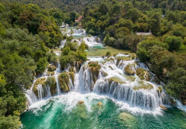
istockphoto