Top 15 Most Colorful Places In The World

Images may become more dramatic than the real thing in a world where smartphones provide a filter, sticker, or effect for every photograph. There are still ... read more...spots, though, where even Photoshop can't touch up the hues that nature's palette creates or the fantasy-like settings that designers have created in everyday communities. Here are some of the most colorful places in the world.
-
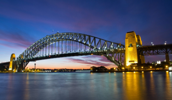
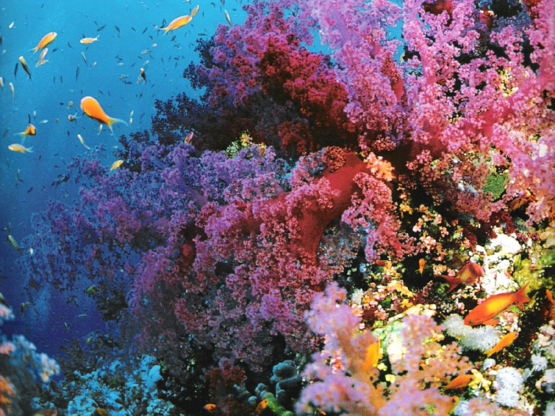
The Great Barrier Reef, which spans over 2,300 kilometers over an area of over 344,400 square kilometers, is the biggest coral reef system in the world. It is made up of over 2,900 distinct reefs and 900 islands. The reef lies in the Coral Sea, off the coast of Queensland, Australia, and is divided from the shore by a channel that is more than 200 feet deep and up to 100 miles wide in some areas. The Great Barrier Reef is the largest single structure created by living things that can be observed from space.
The Great Barrier Reef's huge size and stunning hues were a challenge to Pixar animators. There are 2,300 kilometers of coral reefs and islands, but other natural wonders also abound. As they eat and establish homes there, the fish add swirls of their own colors. However, because of the death of the coral, which is extremely sensitive to water temperatures, due to rising oceans, the reef has lost some of its color. The coral reef bleached out in vast areas over hundreds of kilometers last summer, and experts fear the next mass extinction is not far off.
The Great Barrier Reef is a significant component of the traditions and spirituality of the Aboriginal Australian and Torres Strait Islander peoples, who have long known about it and exploited it. Tourists love to visit the reef, especially those from the Whitsunday Islands and Cairns. With an annual economic output of nearly $3 billion AUD, tourism is a significant industry in the area.
Location: Off the east coast of the Queensland mainland, Australia
blogspot.com 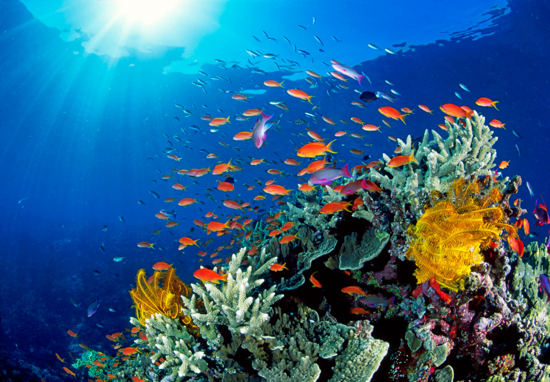
blogspot.com -
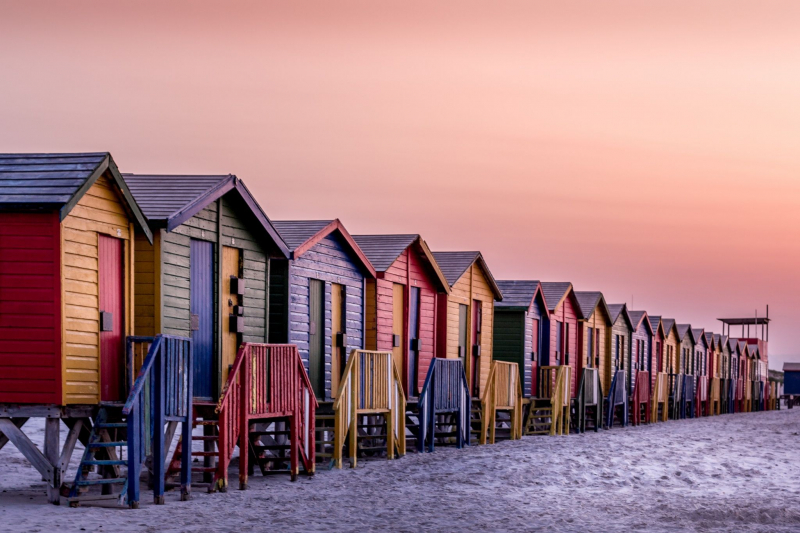
South Africa's Western Cape has the beachside community of Muizenberg. It is located on the False Bay shoreline, where the Cape Peninsula's eastern side swings around. It is regarded as Cape Town's primary surfing location and is presently the home of a surfing community, focused around the well-known "Surfer's Corner". Victorian bathhouses, painted in vivid primary and secondary hues as though from a kindergarten painting kit, along the spacious beach at Muizenburg. The tiny homes date back to a time when ladies used to walk to the beach fully and elaborately dressed and required a space to change into their slightly less bulky bathing attire.
The bright colors still have a connection to former times, even if the bathing boxes are now more likely to house surf boards or a family's supplies for building sandcastles. Sir Herbert Baker, a renowned architect, created "Sand Hills", his residence on Atlantic Road, "Vergenoegd", located farther down the same road, and "Coel a Mar", located on Main Road. Muizenberg has a large number of art deco-style buildings that were constructed during the height of the resort town's development. At its height, the Muizenberg beachfront drew huge crowds of tourists, earning the name "The Snake Pit" for the beach in front of the pavilion. It had a sizable Jewish community who frequented the Camp Road synagogue.
Location: City of Cape Town, Western Cape, South Africa
Pinterest 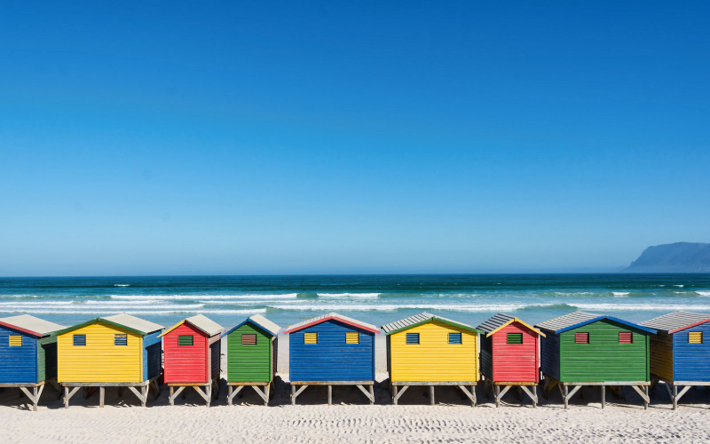
worldbeachguide.com -
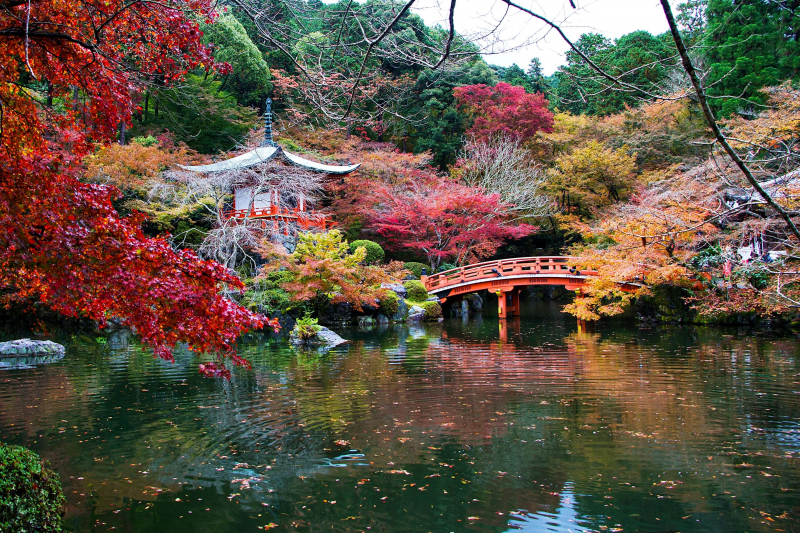
In Fushimi-ku, Kyoto, Japan, there is a Shingon Buddhist temple called Daigo-ji. Yakushi is its primary devotion, or honzon. Daigo, which means literally "ghee", is used metaphorically to denote the "crème de la crème" of Buddhist ideas. Daigo-ji, a Shingon Buddhist temple and UNESCO World Heritage Site, is located just southeast of Kyoto. Come during the fall to witness the brilliant red foliage lighting up Benten Pond. A five-story pagoda from the 9th century is hidden behind the blazing vegetation. It perfectly embodies Kyoto's old-world charm.
The kond and the five-story pagoda are two examples of the many buildings that qualify as national treasures of Japan. The temple is home to several dozen significant cultural treasures, including the structures and other works that make up the 18 specially declared national treasures. Academic study of the temple's wall murals resulted in the Imperial Prize of the Japan Academy in 1960. It is included as a World Heritage Site because it is one of the "Historic Monuments of Ancient Kyoto." The oldest structure in Kyoto is the five-story pagoda of the Daigoji temple, which dates back to 951. One of the few structures to survive the Onin War in the fifteenth century was this one.
Location: Fushimi-ku, Kyoto, Japan
japanbyjapan.com 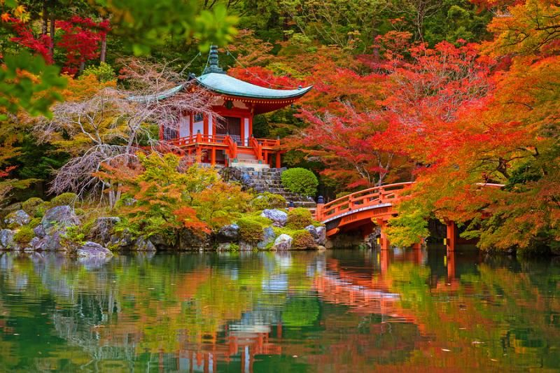
japanbyjapan.com -
You may have previously seen a picture of a sea of blue flowers and rolling hills against an unobstructed blue sky. While you would assume that a sight this beautiful could only have been created using advanced CGI, this location actually exists just outside of Tokyo! Visit the Hitachi Seaside Park to admire the breathtaking scenery of Ibaraki Prefecture.
Hitachi Seaside Park provides a getaway from the hustle and bustle of city life and is situated just outside Hitachinaka City in Ibaraki Prefecture, about 120 kilometers northeast of Tokyo. Before the site was given up to the Japanese government in 1973, the park was used as an American military facility. It was decided to turn the area into a public park after significant thought was given to what to do with it. Since it initially welcomed guests in 1991, Hitachi Seaside Park has grown to be a popular destination for families, couples, and tourists looking for a stress-free getaway in the great outdoors. Six distinct regions that each provide something somewhat different make up the park.
The park's 215 hectares are accessible to the public, and each season sees colorful flowers blossom there. The view is particularly good from Miharashi Hill. Miharashi Hill becomes a pastel blue in the spring thanks to 5.3 million nemophila blooms. With the neighboring blue sky and water, nemophila flowers make an amazing tableau of contrasting blues. The 32,000 green Kochia shrubs in the park turn red in the fall.
Location: Mawatari Onuma, Hitachinaka
blogspot.com 
travelazzi.com -
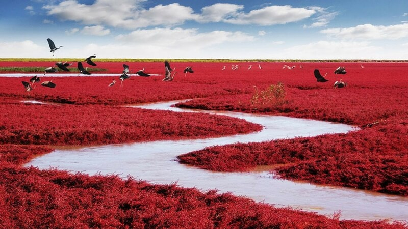
The Panjin Honghaitan Scenic Area, commonly known as Panjin Red Beach, is situated in China's Bohai Bay, some 40 kilometers (25 miles) from Panjin City in the Liaoning Province. This picturesque location earned its name from a big area of red seepweeds, which from around April to October every year completely color the earth red. In reality, Panjin Red Beach is a wetland that is covered in paddy rice fields, reeds, and seepweeds. It is also a haven for numerous water birds, making it a superb tourist destination for anyone who admire the beauty of nature.
Mid-September to mid-October is the ideal time to explore Panjin Red Beach. Seepweeds begin to develop in April and have tender red leaves at first. The hue progressively becomes darker over time, turning vivid crimson in the fall. These grasses change from red to purple as it becomes chilly after mid-October. The length of Panjin Red Beach is 18 kilometers (11 miles). There are sightseeing buses that go between the numerous picturesque locations inside the scenic region.
Red Beaches should be visited early in the day. Visitors are limited to taking backlit pictures in the afternoons. Two options exist for appreciating its beauty: either strolling along the long wooden plank road that was constructed over fields of seepweeds or riding a boat through the vibrantly colored fields. The picturesque places, such as Yishui Yunzhou and Langqiao Aimeng, make for the ideal viewing locations.
Location: Sigan Road Nearby, Panjin, Liaoning, China
Matador Network 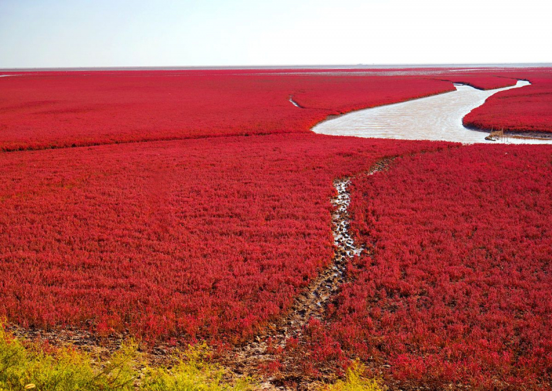
theawesomedaily.com -
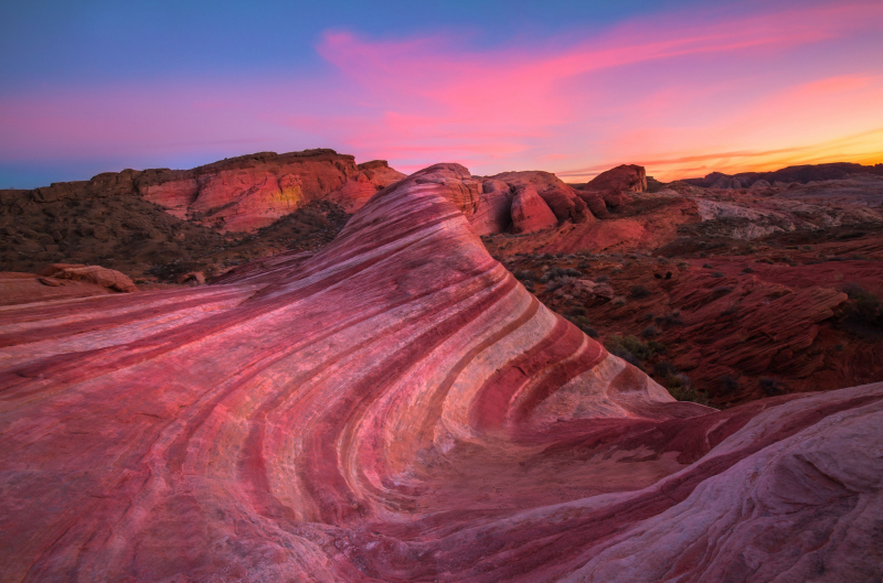
Only six miles separate Valley of Fire State Park from Lake Mead, and it is 55 miles from Las Vegas to the northeast via Interstate 15 and exit 75. Valley of Fire State Park, established in 1935, is Nevada's oldest and biggest state park. The Mojave Desert's harsh beauty and red sandstone formations are whence the valley gets its name. Petrified wood and 3,000-year-old Indian petroglyphs are found in various places around the park, representing ancient trees and early humans. Camping, hiking, picnics, and photography are all popular pastimes. A comprehensive visitor center with several explanatory displays is available in the park. There are also a number of places for group usage. All year long, the park is open.
The red sandstone rocks of the Valley of Fire, which date back 150 million years to the time of the dinosaurs, are what give the region its name. The current terrain was formed by significant erosion, complex rising, and faulting of the area. The limestones, shales, and conglomerates are further significant rock formations. The Basket Maker peoples and subsequently the Anasazi Pueblo farmers from the surrounding fertile Moapa Valley were among the prehistoric inhabitants of the Valley of Fire.
Exhibits about the geology, ecology, prehistory, and history of the park and the surrounding area are available in the visitor center. Every tourist is highly encouraged to make this their first stop after entering the park. For your convenience, postcards, literature, and souvenirs are for sale. Daily hours for the visitor center are 9:00 a.m. to 4:00 p.m. At dusk, the park's other areas close.
Location: Overton, NV
ThoughtCo 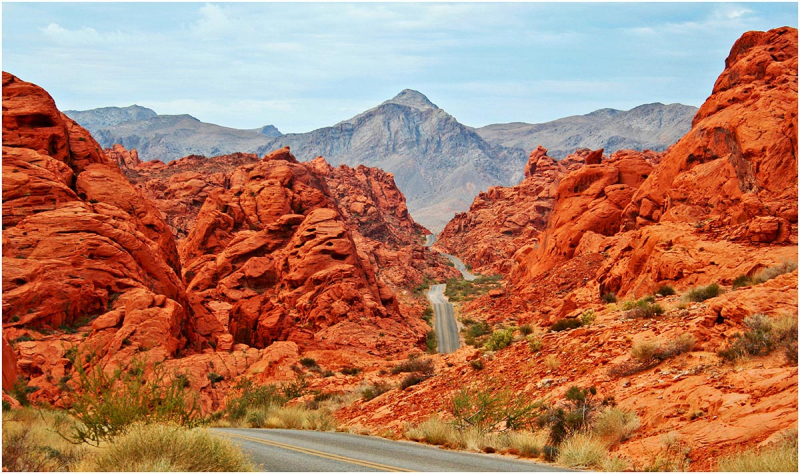
nevadafilm.com -
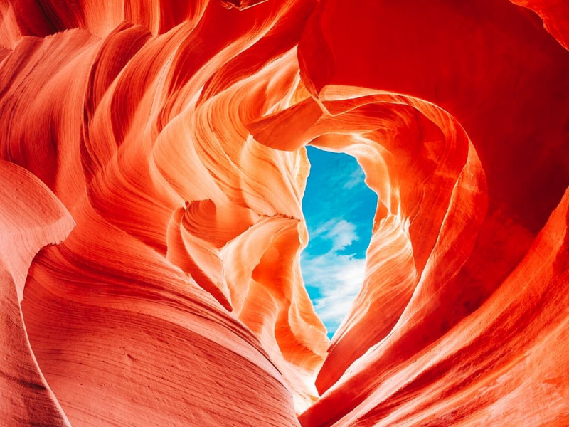
In the American Southwest, Antelope Canyon, is known as the "canyon capital of the world", home to canyons ranging in size from the enormous Grand Canyon to those that are so tiny that even the skinniest individuals would have difficulty passing through. The spectacular canyon, which was shaped over millions of years by water and wind erosion, was given its name after the pronghorn antelope herds that originally frequented the region. You have your work cut out for you in terms of exploring as there are two distinct canyon portions, higher and lower.
While most of the hiking trails in the region are level, the sand and sandstone surface is usually difficult to navigate. With ground-level entrance, Upper Antelope Canyon is the area that is easiest to trek. Visitors must walk 20 minutes on sandy pathways with some steep metal stairs and walkways to return to the parking area. The most daring are drawn to Lower Antelope Canyon, where they negotiate a lengthier sandy climb to the canyon and multiple elevation changes with stairways and ladders to enter the canyon. The 9.8-mile Page Rimview Trek offers hikers additional time on the trail. Views of the canyonlands, Lake Powell, Glen Canyon Dam, and the area's impressive rock formations may be had from the route.
Location: Hwy, Page, AZ
travelmelodies.com 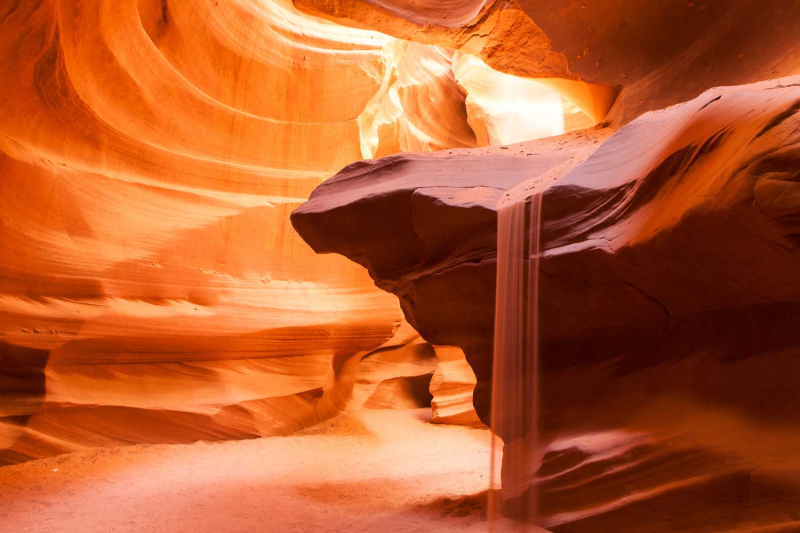
horseshoebend.com -
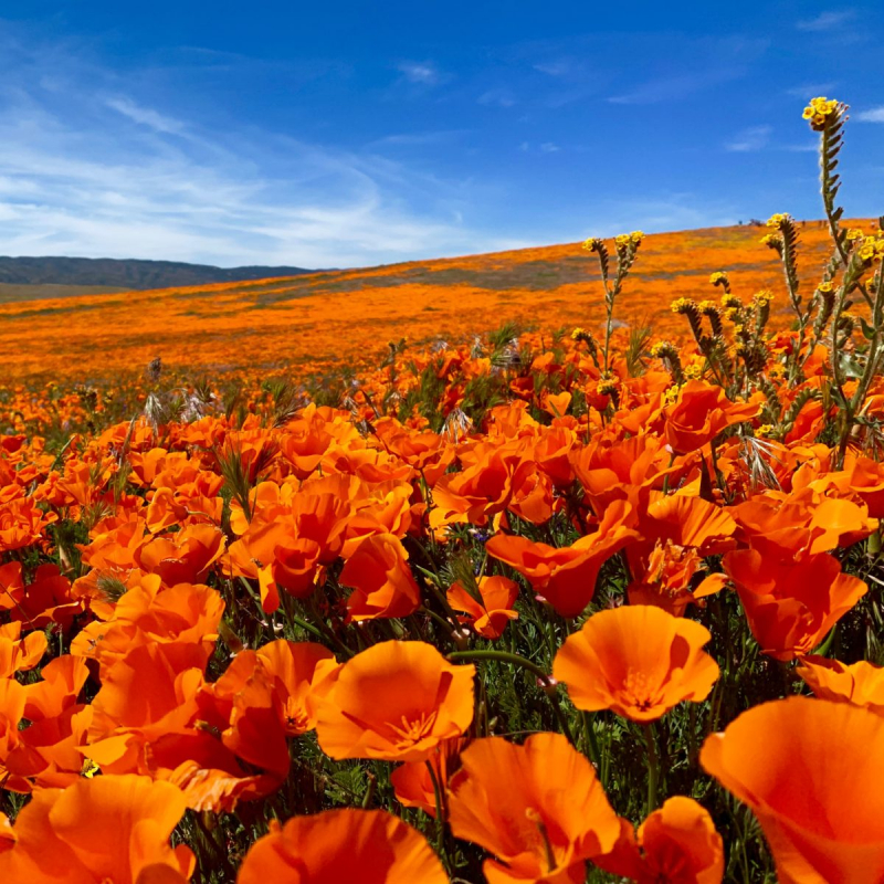
Get ready for an amazing display each spring at Antelope Valley Poppy Reserve. You may see California poppies, the state's official flower with innumerable vivid orange petals shimmering in the sunshine, in technicolor in the isolated hills west of Lancaster. It's convenient for a fast nature retreat because it's just about an hour and a half (depending on traffic) outside of downtown Los Angeles. Every spring, the Mojave Desert Grassland ecosystem surprises bring life to the Antelope Valley California Poppy Reserve. Colors and fragrances change with the seasons in terms of their intensity and duration. A variety of wildflowers create a shifting color mosaic during the wildflower season, which often lasts from as early as mid-February through May.
The park is a fantastic location for hiking and exploring at any time of year thanks to its eight miles of paths that wind through the gently sloping hills and include a paved part for wheelchair access. Get out of the city and unwind in the peace and quiet of the countryside where birds may be heard singing and hawks can be seen soaring overhead softly. The benches along the pathways are ideal spots to relax and observe the local fauna, including gopher snakes, lizards, and meadow larks. You could be fortunate enough to see a coyote or bobcat. Around the pathways, there are a lot of tunnels where mice, gophers, kangaroo rats, beetles, scorpions, and other creatures may live.
Location: Lancaster Rd, Lancaster, California
flyinghighonpoints.com 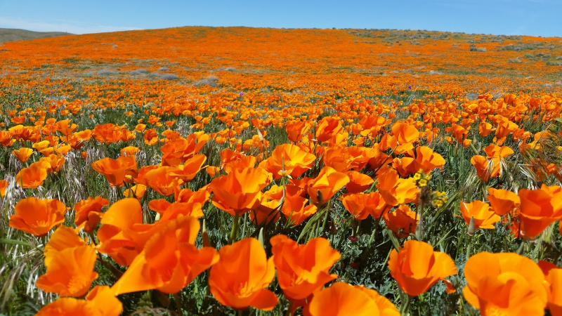
blogspot.com -
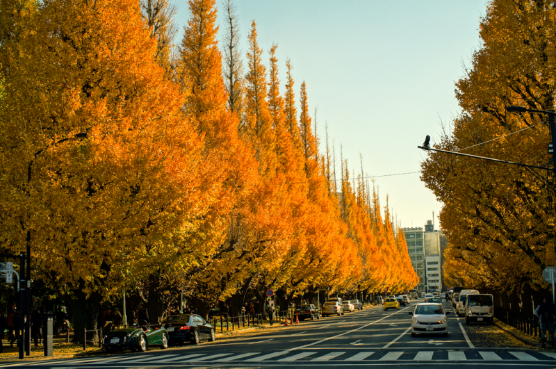
It's reasonable to say that Ginko Avenue is one of those vibrant spots that merits a space in the rainbow, with 300 meters of glorious, brilliant yellow ginko tree splendour. This well-known autumn path provides an unassuming respite from the sprawling concrete jungle in the center of busy Tokyo. Even more people gather to view the colors when October arrives.
The genus Ginkgo, which includes the species Ginkgo biloba, was formerly widely distributed around the globe, but its numbers began to decline approximately two million years ago. The sole remaining species in the phylum Ginkgophyta is ginkgo biloba. All of the others vanished. Currently, the species can only be found growing naturally in a tiny area of Zhejiang province in eastern China. The Chinese have been growing gingko for a very long period; several of the trees are more than 1,500 years old. When a German botanist spotted the tree in the gardens of a Japanese shrine, he was the first European to learn about it. They have been cultivated in North America for more than 200 years and are now widespread there as well as in Europe.
Location: Minato, Kitaaoyama, Japan
Flickr 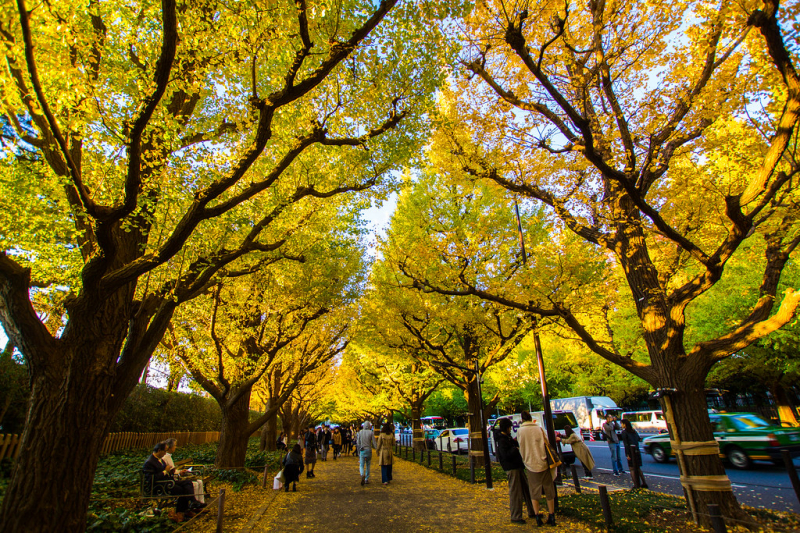
Flickr -
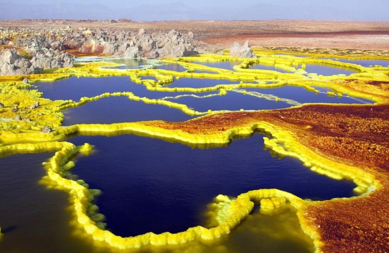
You are staring at one of the toughest places on the planet. Pretty to look at but semi-terrifying to touch, Ethiopia’s Danakil Depression, located in Dallol, is quite literally the hottest place on Earth (and one of the Earth’s most colorful places!). You could be distracted from the fact that the average yearly temperature is over 94 degrees fahrenheit by the colorful hydrothermal pools and crusty salt lakes.
Dallol's high humidity (about 60 percent) and the toxic gases that rise from its sulfur ponds, which have a Hades-like appearance, are not the only things that make the place so hot. It also doesn't cool off at night. Dallol has an average low temperature of 87 degrees Fahrenheit, which is hotter than many locations on Earth ever receive. While many of the world's hot spots are situated in deserts, where temperature differences between day and night are just as severe as those experienced during either.
Dallol is regarded as a "ghost town", meaning that nobody resides there permanently. There have been a number of commercial businesses in the past in and around Dallol. Operations have mostly focused on mining, from potash to salt, however due to Dallol's isolation, these ended in the 1960s. Dallol is also far away. Although a railway connected Dallol with the port of Mersa Fatma, Eritrea, in the early 20th century, today, if you wish to travel independently, the only way to get to Dallol is by camel.
Location: Dallol, Ethiopia
sometimes-interesting.com 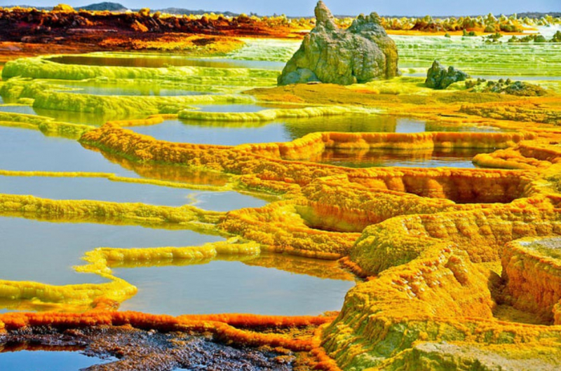
sometimes-interesting.com -
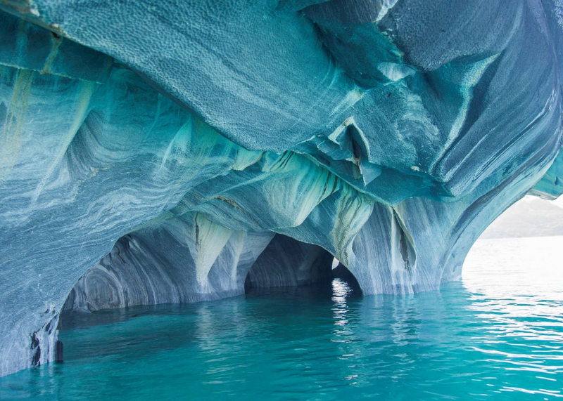
Imagine yourself traveling through the placid waves of Chile's biggest glacial lake to a lonely marble building that is hidden among a little cluster of rock islets. The moment your boat's bow passes through the solid grotto's mouth, you are met by a ceiling covered in strong, swirling lines that are so vivid they appear to have been painted on. The surrounding rock walls, which are painted in a variety of blue hues, including sapphire, seafoam green, and turquoise, catch your eye. The natural beauty that surrounds you underneath you is something you don't notice until your neck gently alerts you that you've been looking up for too long.
You are in amazement of the planet that exists kilometers below the surface until, with a tiny movement of your attention over the edge of the boat, you notice distinct rock structures plainly through the translucent water. You have arrived to the Marble Caves in Chile, a unique and unusual experience. As more people embark on their ideal Patagonia tours, The Marble Caves are becoming an increasingly popular tour destination.
Although the Marble Caves are a magnificent site, they are also quite remote. There isn't really a simple method to get there. The Marble Caves may only be reached by boat, kayak, or ferry. The caverns are not accessible by car, and there is nowhere inside them for you to go on a paved walkway. This will be an all-aquatic excursion instead.
Location: Patagonian Andes, Chile
audleytravel.com 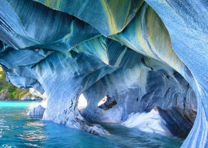
audleytravel.com -
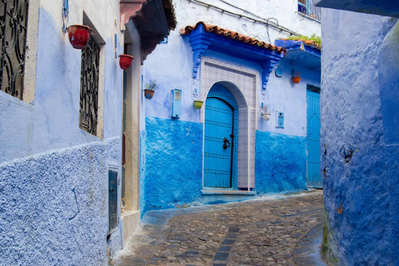
The city's blue tint would be the only way to adequately define it or set it apart from others. Every hue of blue is available. Two of the many hypotheses that explain this strange hue stand out. One explanation holds that it stems from the widespread perception in the area that mosquitoes dislike the color blue. According to the most widely accepted version, Jewish locals painted their section of town a distinctive shade of blue to set it apart from the Muslim green that is frequently seen on doors and windows across Morocco. The remainder of the residents were drawn in by the lovely blue to the point that they painted the entire town that color.
Chefchaouen is distinguished by its color and its pleasant inhabitants, regardless of whether of these beliefs is accurate. It has acquired its reputation as one of Morocco's most enchanting and attractive cities. Additionally, you may find a number of interesting structures here, including the Alcazaba and the Great Mosque, as well as non-religious structures of outstanding cultural importance, such the magnificent natural spring where water gushes out of the mountain. Chefchaouen is the ideal entry point for individuals who enjoy trekking and the beauty of the mountains. Overall, Chefchaouen is the ideal Moroccan city in which to simply stroll around the medina's narrow streets. Whether you're a photographer or not, you'll undoubtedly find yourself pausing to take photos of the city's stunning scenery.
Location: Chefchaouen, Morocco
odysseytraveller.com| 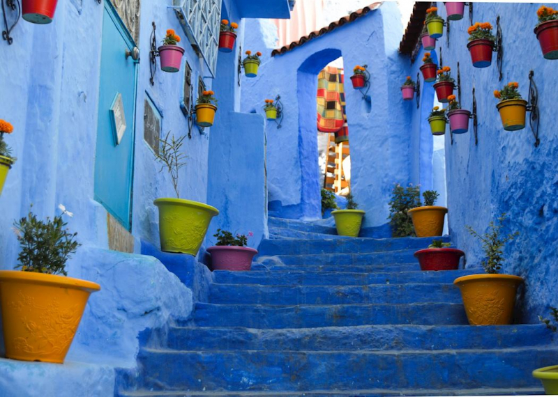
audleytravel.com -
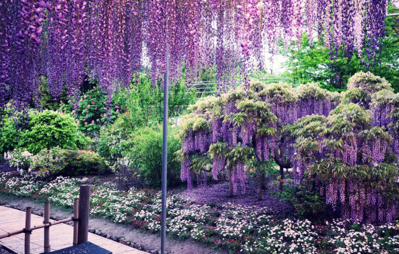
The two 100-meter-long wisteria tunnels that run through the Kawachi Fujien Wisteria Garden, located in the hills southwest of Kitakyushu, are its most notable feature. Two times a year, in the spring and in the fall, the gardens are accessible to the general public. The park is a little challenging to get to. From Yahata Station, it takes 15 minutes via bus, then an additional 55 minutes to walk to the gardens. Wisteria may be seen growing on the two tunnels in the park's middle and as a cluster of trees arranged to resemble a huge dome.
The wisteria plants are available in a variety of colors, including dark purple, blue, and white. You may look down on the sea of wisteria from a vantage point in the park. The wisteria peak blooming time falling around the Golden Week vacation period has caused visitor numbers to soar. The garden has become more and more well-liked in recent years. You must reserve tickets for a certain date and time window in advance to enter during the busiest season, which runs from late April through Golden Week.
Kawachi Wisteria Garden has gained a lot of popularity in recent years and now draws a sizable local and foreign tourist population during the wisteria season, which frequently coincides with the hectic Golden Week. During the springtime peak, visitors must make reservations in advance to enter the garden.
Location: Kitakyushu, Kawachi, Yawatahigashi-ku
japandeluxetours.com 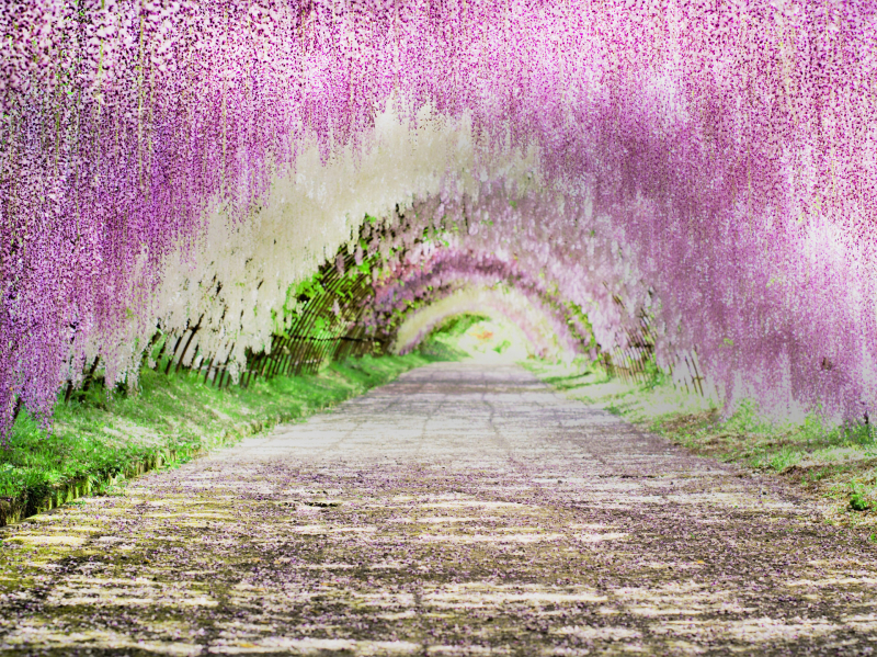
japandeluxetours.com -
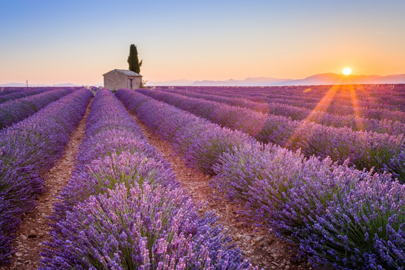
The greatest time to visit Lavender Fields, Provence is during the lavender blooming season, but this is a journey that cannot be spontaneous because the blossoming season only lasts a few weeks and varies depending on the region. You need to carefully organize your journey if you wish to see the Provence lavender fields. Understanding the Provence lavender season, the top locations to see lavender, and the blossoming times for each region are crucial. You also need to reserve lodging, a rental vehicle, or guided excursions much in advance because the tour of these French lavender fields is a highly seasonal activity.
The greatest time to visit Provence is during the lavender blooming season, but this is a journey that cannot be spontaneous because the blossoming season only lasts a few weeks and varies depending on the region. You need to carefully organize your journey if you wish to see the Provence lavender fields. Understanding the Provence lavender season, the top locations to see lavender, and the blossoming times for each region are crucial. You also need to reserve lodging, a rental vehicle, or guided excursions much in advance because the tour of these French lavender fields is a highly seasonal activity.
Location: Provence, France
mackintoshfrance.com 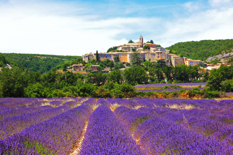
mackintoshfrance.com -
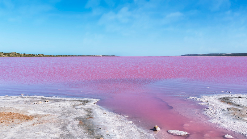
On the journey between Port Gregory and Kalbarri, the waters of Hutt Lagoon can occasionally be a stunning shade of red, lilac, or even brilliant bubblegum pink. Before sunset, go outside and observe how the colors change. You can get to Hutt Lagoon from Perth by using the Indian Ocean Drive in less than six hours. Within 30 minutes, if you're coming from Kalbarri, you'll catch your first view of the lagoon. The most distinctive view is available from Geraldton by scenic flight, with the Indian Ocean standing out against the pink lake.
The lagoon's peculiar colour is a result of the exceptionally high saline level, and its brightness varies with the season and time of day. The best time to go is in the middle of the day or just before sunset on a clear day. Along Port Gregory Road, there are several locations to stop and take in this natural spectacle. The charming fishing community of Port Gregory is tucked away between Hutt Lagoon and the seashore. Choose from farmstays, chalets, beach cottages, and the trailer park for your overnight accommodation after picking up refreshments at the local shop.
Location: Gregory, Australia
windows10spotlight.com 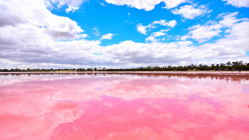
delhiplanet.com