Top 8 Longest Land Borders In The World

Many landlocked nations on the planet have borders with one or more neighbors. The most neighboring nations and those with land boundaries spanning thousands ... read more...of kilometers are China and Russia. Other, much smaller countries, like the Vatican, have borders that don't even reach double digits. On the other hand, with the exception of Ecuador and Chile, Brazil covers practically all of South America. There are 16,145 kilometers along the broad boundary. That is more over 10,000 miles! Here is the list of longest land borders in the world for you.
-
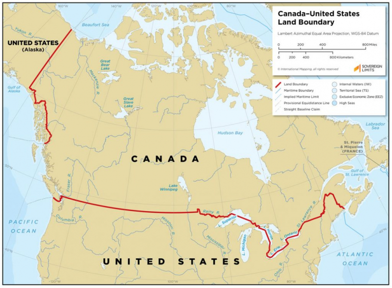
The longest international border in the world shared by the same two countries is the border between the United States and Canada, also referred to as the International Boundary. The terrestrial boundary is 8,891 kilometers (5,525 miles) long, including 2,475 kilometers (1,538 miles) that are shared with Alaska. It also includes tiny segments of marine boundaries on the Atlantic, Pacific, and Arctic coasts as well as the Great Lakes. It is the sole land border with Canada.
The American Revolutionary War between Great Britain and the United States was put to a conclusion by the Treaty of Paris in 1783. The parties stipulated all of the United States' borders in the second article of the Treaty, including but not limited to the northern border along what was then British North America. The line that connected the northwest corner of Nova Scotia to the Connecticut River's head and continued down the center of the river to the 45th parallel of latitude was included in the mutually agreed-upon boundary.
Even though there is civilian law enforcement present, the International Boundary is sometimes referred to as the "longest undefended border" in the world. Outside of border controls, crossing is prohibited because everyone entering or leaving the country is subject to immigration and customs checks. Contrast this with the United States-Mexico border, which is actively guarded by U.S. Customs and Border Protection agents to stop illegal immigration and drug trafficking and is one-third the length of the Canada-U.S. border.
Length: 8,891 kilometers
Source: Flickr 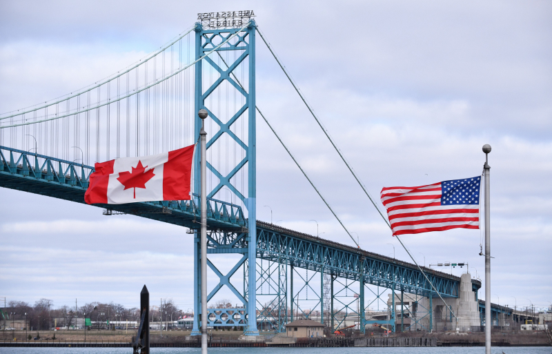
Source: Pinterest -
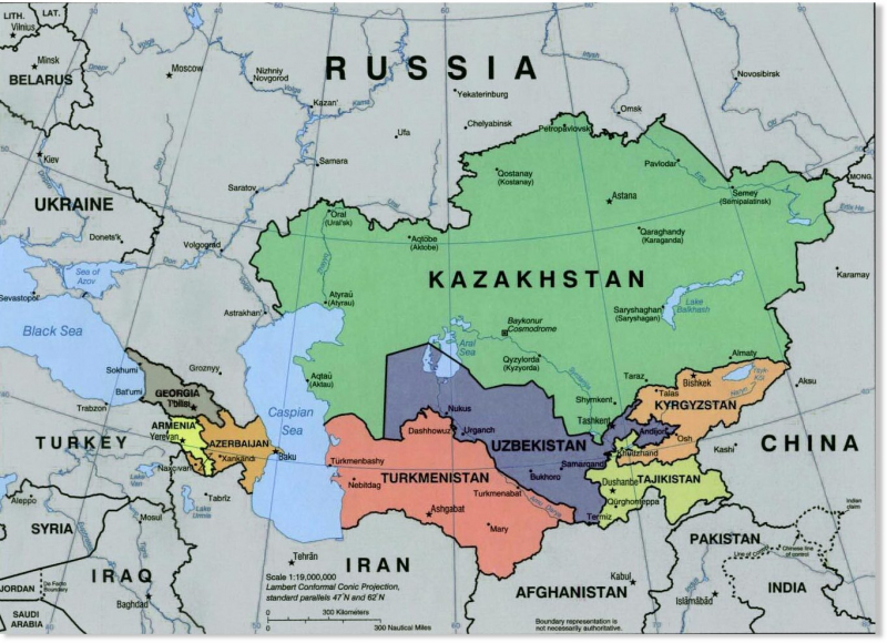
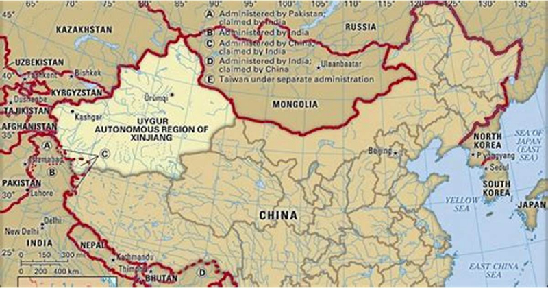
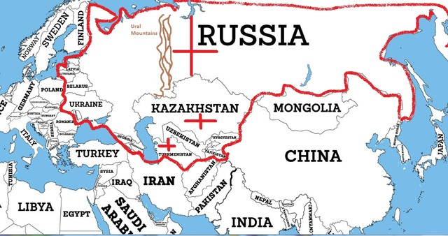
The 7,644 kilometer (4,750 mi) international boundary separating the Russian Federation and the Republic of Kazakhstan is known as the Kazakhstan-Russia frontier (Russian: ааcтанско-россиска раниа, Kazakh: аастан-есе екарас). After the border between Canada and the United States, it is the longest continuous international border in the world and the second longest overall. It is situated where the administrative-territorial border between the Russian Soviet Federative Socialist Republic and the Kazakh Soviet Socialist Republic once stood.
The boundary, which begins in the west at the Caspian Sea and generally runs in a west-east direction to the tripoint with China, is exceedingly complicated in some locations. Although rivers like the Maly Uzen, Ural, and Uy are used in some places, the border is largely made up of overland boundaries that cross the Eurasian Steppe. The border crosses Botkul Lake. The border passes via the Altai Mountains in the far eastern region.
Length: 7,644 kilometers
Source: wowtravel.me 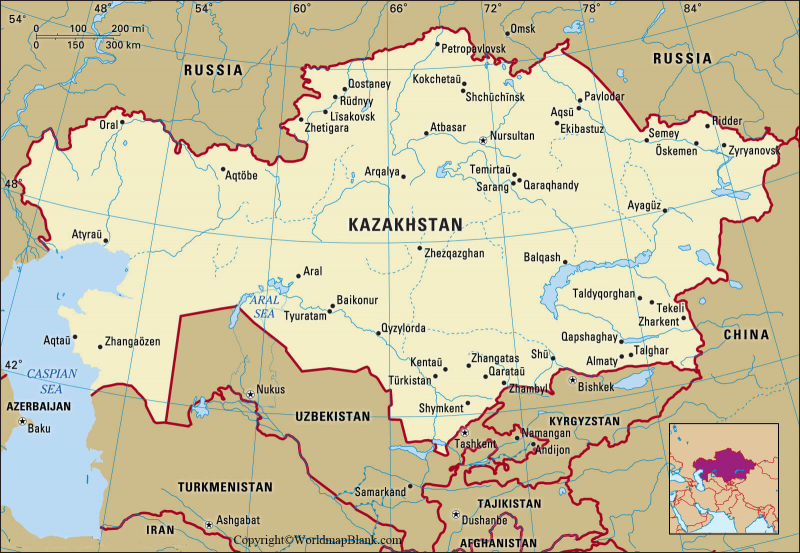
Source: Flickr -
The boundary, which begins in the west at the Caspian Sea and generally runs in a west-east direction to the tripoint with China, is exceedingly complicated in some locations. Although rivers like the Maly Uzen, Ural, and Uy are used in some places, the border is largely made up of overland boundaries that cross the Eurasian Steppe. The border crosses Botkul Lake. The border passes via the Altai Mountains in the far eastern region.
In the dry Puna de Atacama plateau, the northern end of the boundary creates a tripoint with those at the borders with Bolivia and Chile. The border stretches southward till it touches the water where the Atlantic Ocean and Strait of Magellan converge. The Isla Grande de Tierra del Fuego's southern boundary follows a meridian that divides the island in half. A few kilometers southwest of Ushuaia, in Beagle Channel, this boundary meets the ocean.
The Treaty of Peace and Friendship of 1984 between Chile and Argentina, an everlasting treaty, was signed at the Vatican by officials of both countries. It came about in November 1984 following protracted talks and mediation by John Paul II. An agreement between Argentina and Chile to define the border line between Mount Fitz Roy and Mount Daudet and put an end to the long-standing dispute was signed on December 16th, 1998. The border between Mount Fitz Roy and Mount Murallón, however, is still up in the air because the two nations couldn't agree on it.
Length: 5,300 kilometers
Source: Flickr 
Source: wowtravel.me -
The international border separating China and Mongolia is known as the China-Mongolia border. It stretches 4,630 km (2,880 mi) from west to east between the two tripoints with Russia, with the majority of the border territory located in the Gobi Desert. It is the fourth-longest international border in the entire planet. Just 100 kilometers (62 miles) east of the tripoint between China, Kazakhstan, and Russia, in the Altai Mountains, the boundary with Russia officially begins. From then, it travels overland typically in a south-easterly direction, with straight line sections predominating in the Gobi Desert area, until it reaches the southernmost point of Mongolia, which is located just north of the 40°30 line of latitude.
The route then continues overland in a north-easterly direction, passing close to Mongolia's easternmost point in the Greater Khingan mountains. From there, the border turns steeply to the north-east up to the eastern Russian tripoint before veering to the north-west and then west, using the Khalkhyn Gol river for a while until passing into Buir Lake. Since 1949, when the Communists have controlled China, relations with Mongolia have steadily improved. On December 26, 1962, the two nations signed a treaty defining their shared border. Then, between 1963 and 1964, the entire border was demarcated, and on June 30, 1964, a final treaty with a thorough set of maps was reached. The boundary has remained in place, and although there have been some stressful moments since then, most notably during the Sino-Soviet split in the 1960s when Mongolia sided with the USSR, overall ties between the two countries have remained friendly.
Length: 4,630 kilometers
Source: Pinterest 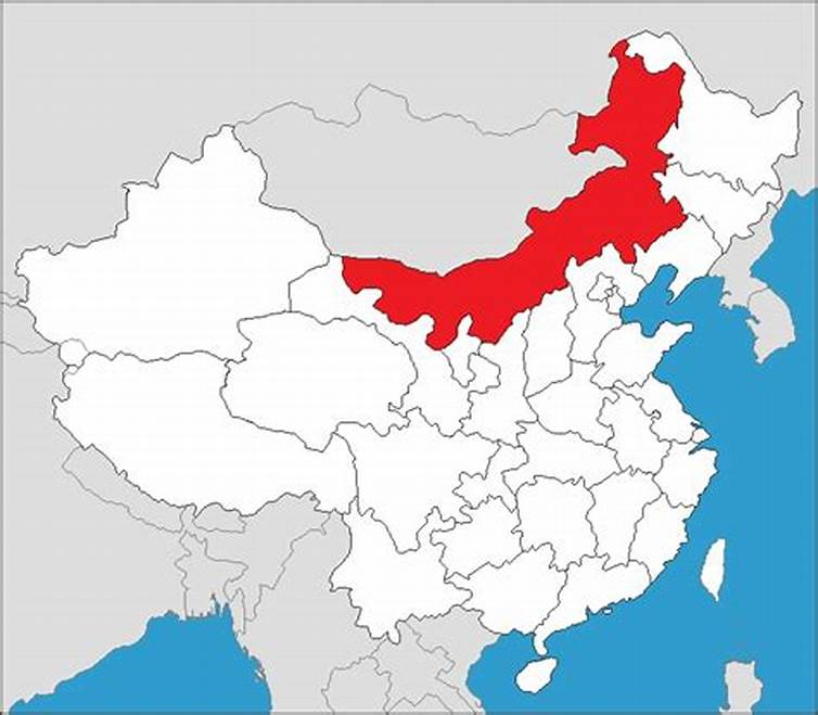
Source: wowtravel.me -
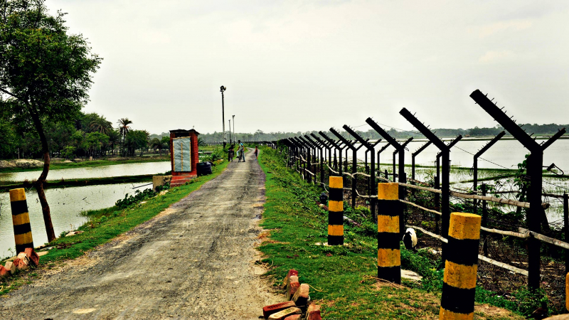
The international border between Bangladesh and India, also referred to as the International Border (IB), separates the eight divisions of Bangladesh and the Indian states. The fifth-longest land border in the world, Bangladesh and India are separated by an international border that is 4,096 kilometers (2,545 miles) long. Along the border are the Bangladeshi divisions of Mymensingh, Khulna, Rajshahi, Rangpur, Sylhet, and Chittagong. The border separating the two states is delineated by several pillars. Fencing is present on both sides of small, clearly marked sections of the boundary.
Following the partition of India, the Radcliffe Line was made public on August 17, 1947, designating the border between India and Pakistan. Early on, Bangladesh was also referred to as East Pakistan. It was given that name in honor of the building's architect, Sir Cyril Radcliffe, who was tasked with separating 88 million people among 450,000 square kilometers (175,000 square miles) of area as the chairman of the Border Commissions.
Since 1974, India and Bangladesh have engaged in eight rounds of bilateral negotiations, each with a different understanding of their maritime boundaries and exclusive economic zones. These negotiations have been fruitless until 2009, when both parties decided to submit their disputes to arbitration under the UNCLOS. The dispute was finally resolved on July 7, 2014, when the Arbitration Tribunal ruled in Bangladesh's favor. This decision was graciously accepted by all parties. South Talpatti (also known as "New Moore"), a small, uninhabited offshore sandbar that became an island in the wake of the Bhola storm in 1970 and vanished around March 2010, was also in dispute.
Length: 4,096 kilometers
Source: wowtravel.me 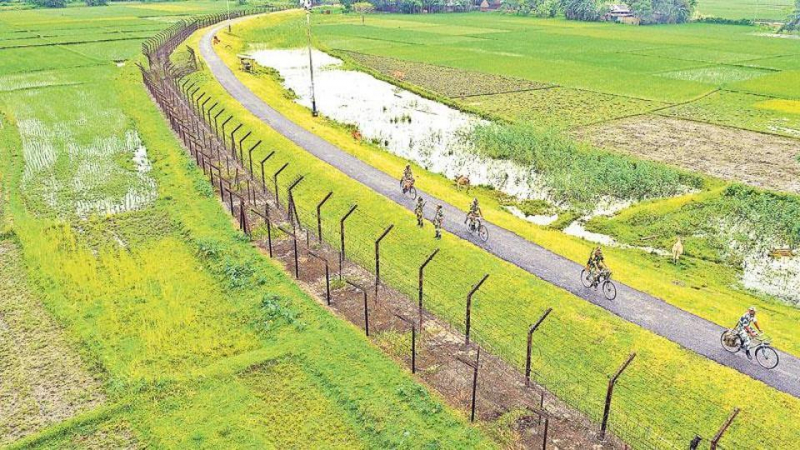
Source: Flickr -
The international boundary separating China and Russia is known as the Sino-Russian border. It is the sixth-longest international boundary in the world after the final demarcation, which was completed in the early 2000s, and measures 4,209.3 kilometers (2,615.5 miles). The border between China and Russia is made up of two independent, non-contiguous sections: the lengthy eastern portion between North Korea and Mongolia and the significantly shorter western section between Kazakhstan and Mongolia. The physical methods of administering the China-Russia border are governed by a bilateral treaty, as is the case with many other international borders. The agreement that is still in effect today was reached in Beijing in 2006.
Civil navigation is permitted on the border rivers and lakes as long as the boats from each nation stay on the proper side of the dividing line; fishing is also permitted in these waterways under identical conditions. The authorities of each country shall take all necessary steps to prevent grazing cattle from crossing into the other country and shall make every effort to arrest and return any such livestock that stray beyond the border. Within 1,000 meters (3,300 feet) of the borders, hunting with guns is forbidden. Hunters are also not allowed to cross the border in pursuit of a wounded animal. Within 7 days after their capture, detained border crossers are typically meant to be sent back to their country of origin.
Length: 3,645 kilometers
Source: wowtravel.me 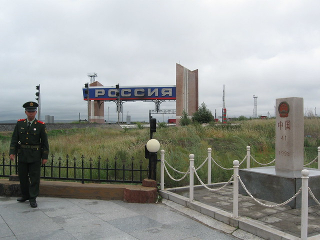
Source: Pinterest -
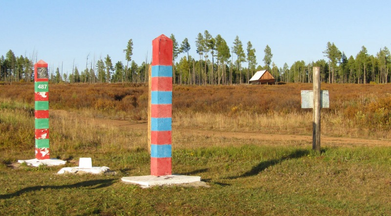
The 2,166-mile-long border between Mongolia and Russia runs along the northern boundary of Mongolia. The Treaty of Kyakhta, an agreement between the Russian Empire and the Qing Empire, outlines the parameters of the current border between the two countries. The initial contract guaranteed that Tuva would stay inside Mongolian territory. However, the territory of Tuva broke away from Mongolia and came under Russian rule after the collapse of the Qing empire. Ten official crossing points between Mongolia and Russia have been established by their respective governments.
Since the Soviet Union backed the Mongolian People's Republic throughout the Communist era, relations between Mongolia and Russia have historically been good. The Organization for Security and Cooperation in Europe accepts both nations as full members (Russia is a participating state, while Mongolia is a partner). 90% of Mongolians, according to a 2017 survey, have a good opinion of Russia (38% "strongly" and 52% "somewhat"), whereas 2% have a negative opinion and 6% have a neutral one.
Length: 3,485 kilometers
Source: Pinterest 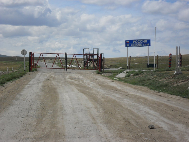
Source: wowtravel.me -
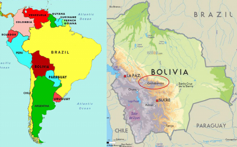
Located in Western South America, Bolivia is a sovereign nation. Officially, it is referred to as the Pluractional State of Bolivia. Bolivia is ranked as the fifth-largest state in South America. The landlocked nation has a total area of 424,164 square miles. The nation upholds solid ties with both its neighbors and other countries, such as Brazil.
On its eastern side, Bolivia and Brazil are separated by a long border. The distance between Bolivia and Brazil is about 2,127 miles. The frontier between the two nations travels through a variety of landscapes, including dense tropical woods, severe desert terrain, and urbanized areas. Relations between Bolivia and Brazil have occasionally been tense. The two neighbors in Latin America engaged in conflict over a plot of productive land in the Amazon basin around the turn of the 20th century. Bolivia selling the territory to Brazil in 1903 led to a resolution of the dispute.
Bolivia and Brazil were embroiled in a contentious disagreement in 2006 over Bolivia's proposal to nationalize its energy sector. Authorities in Brazil were worried that Petrobras, a Brazilian energy corporation operating in Bolivia, would not receive appropriate compensation under the proposals for nationalization. Brazil and Bolivia resolved their conflict in February 2007 in an effort to strengthen regional integration.
Length: 3,400 kilometers
Source: wowtravel.me 
Source: Pinterest