Top 10 Most Remarkable Geoglyphs

Geoglyphs are fascinating and perplexing artistic and cultural artifacts, many of which continue to defy efforts to date or even uncover who created them, let ... read more...alone why. Here are 10 of the most remarkable geoglyphs found around the world.
-
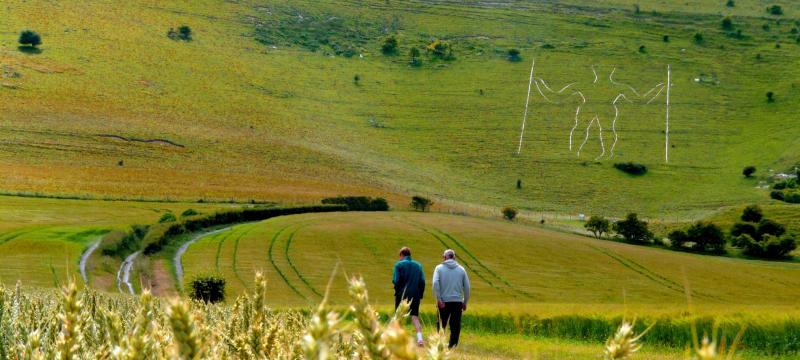
The Long Man of Wilmington, England, stands over 230 feet tall and is considered to date back to 10,000 B.C.E. It serves as a guide across East Sussex. He is etched into the dirt, holding two spears parallel to his body. Since his discovery in the 1700s, experts have been puzzled as to when and who created him. While some scientists believe he was built in the Iron Age, others believe he was created in the 16th or 17th centuries, and some neo-pagans believe the Long Man is an ancient sacred sight.
During WWII, the sculpture was painted green to prevent enemy aviators from mistaking it for a landmark. In 1969, the bricks were replaced with concrete blocks, which are currently painted on a regular basis to preserve the Long Man visible from several kilometers away.
Neo-Druids were enraged in 2007 when ladies lay on the grass to give the Long Man feminine traits such as hair, lips, and breasts, stating that the prank was vandalism on a hallowed item. However, in 2010, pranksters put a large member between the geoglyph's legs, giving the phrase "Long Man" new meaning.
Location: Windover Hill, Wilmington, East Sussex, England
Founded: First recorded 1710
geographical.co.uk -
Andrew Rogers has been creating the world's most spectacular contemporary land art project, Rhythms of Life, since 1999, successfully illustrating how art and nature can complement each other. This is a massive land art project with 51 sculptures spread across 16 nations and seven continents. Nearly the course of 16 years, it has involved over 7,500 people. The seventh continent, Antarctica, serves as the final link.
For Rogers, the inspiration for these works of art - a chain of stone sculptures, or geoglyphs, that have taken shape across mountains, valleys, and plains around the world - came from a desire to designate separation from the everyday and give quiet settings. The Rhythms of Life land art constructions serve several functions, including establishing consecrated space, providing incentive to reveal linkages between structures and nature, and allowing for contemplative storytelling around the search for history.
It is with this in mind that each construction will fade over time, leaving traces of both cultural monuments and those who envisioned them. As a result, Rogers tries to make each artwork using only locally accessible materials, ensuring that indigenous vegetation is not damaged. Each invention is designed with the help of local communities, which include elders, local workers, and professionals.
"Art done by many people for many people," according to Rogers' land art project. His geoglyphs were inspired by the Nazca lines in Peru, one of the earliest types of land art. Rhythms of Life is a contemporary land art project of extraordinary scale and scope in modern history.
Location: 16 countries on seven continents
Date: 1998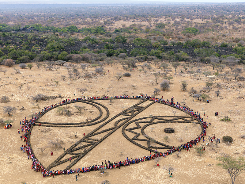
flickr.com -
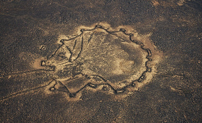
The Works of the Old Men (as they are known by the Bedouins) are located not far from the Dead Sea and consist primarily of big geometric shapes complemented by smaller ones and lines that crisscross their forms. The majority of them appear to be round, wheel-like formations, while a handful are oblong and rectangular in shape. Some are isolated, while others are surrounded by other geoglyphs of the same type. One of them, designed like a gigantic kite, is also considered to have been utilized in some form of hunting system.
However, as with the other geoglyphs on this list, it is unknown when or who erected the Works of the Old Men. Some scientists believe the site is between 3,000 and 5,000 years old, but others believe it is far older, possibly 8,000 or 9,000 years old. That would place them on par with some of the oldest geoglyphs ever discovered on Earth.
Location: Azraq
Founded: First recorded 1710
sciencedirect.com 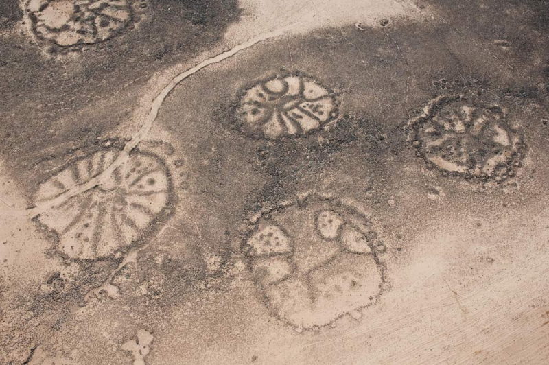
livescience.com -
The Russian Moose geoglyph, which measures 900 by 12 by 15 feet and borders the Zyuratkul lake in Russia's Ural Mountains, is claimed to be the oldest in the world, dating back more than 6,000 years. While looking through Google Earth photographs, a local researcher named Alexander Shestakov uncovered it. Shestakov then flew a seaplane and a paraglider over the area, followed by an archaeological investigation.
The moose is likely to have been created by a local megalithic civilisation, and both children and adults are thought to have assisted in the digging of its vast ditches. However, it is widely assumed that the adults of the tribe did not use forced child labor. The construction of the moose geoglyph was a collaborative effort to impart the common ideals of the tribe's culture in the children who assisted in its construction. However, who those people were and why they created the moose geoglyph remain unknown.
Location: slopes of the Zyuratkul Mountains, Chelyabinsk region
Founded: First recorded 2011
uraloved.ru -
The Atacama Desert is one of the most Remarkable Geoglyphs. It is driest non-polar deserts on the planet. It runs across Peru, Chile, Bolivia, and Argentina. The desert also has over 5,000 geoglyphs, one of which has provoked great controversy in the scientific world. The Atacama Giant is an enigma that has plagued archaeologists for years, set against the backdrop of the Atacama Desert's felsic lava structures and reddish sand pointing toward the Andes highlands. Radiocarbon dating on geoglyphs is tricky and frequently yields controversial results, however some scientists believe the Atacama Giant dates back to 600 C.E.
The geoglyph is a basic stick figure of a guy with his arms up and what appears to be a crown on his head. Some archaeologists believe the Giant has astronomical significance and was used to mark the changing of the seasons. The moon can be seen rising over it from time to time, illuminating the Giant's crown. However, most archaeologists disagree on the meaning or origins of the geoglyph.
Location:Iluga, Chile, Tarapacá, Chile
Date: N/a
imgur.com imgur.com -
American Indian ceremonial mounds can be found all over the country, but only in northeastern Iowa, along the high bluffs and lowlands of the Upper Mississippi River Valley, have so many of these mounds been discovered in the shape of animal effigies. Effigy Mounds National Monument, established in 1949, protects several instances of pre-contact American Indian mounds, allowing visitors to witness spectacular evidence of, and gain a better understanding of, the Woodland period American Indian mound building culture.
The 2,526-acre Monument protects over 200 mounds, including 31 bear and bird effigies. The mounds were erected by the Woodland Indians. The Woodland Culture, which lasted from 500 B.C. to around 1200 A.D., is divided into three distinct sub-cultures: the Early Woodland (also known as the Red Ochre), the Hopewellian, or Middle Woodland, and the Effigy, or Late Woodland. American Indians began erecting earthen effigy mounds in the shapes of mammals, birds, and reptiles between 800 and 1,600 years ago, during the Late Woodland period.
The hunter-gatherer society that erected these mounds thrived on the Mississippi's abundant natural resources, including its waterways, wetlands, and woods. In the summer, they camped by the river, and in the winter, they sought sanctuary under limestone rock outcrops in northeast Iowa. They ate fresh water mussels, wild rice, nuts, fruits, and berries, and hunted white-tailed deer, bear, bison, turkey, and waterfowl to survive. Visitors to the Monument can experience a wetland comparable to the ones that Indians in northeastern Iowa relied on for survival on the two-mile round-trip Yellow River Bridge Trail.
It is unknown why these mounds were built. Archaeologists and academics believe that some of the mounds were constructed for religious events, burial ceremonies, clan insignia, or possibly to connect people to their ancient ancestors and the spiritual realm. Visitors to the Monument can see examples of the four various types of earthen mounds found in this area, as well as the four different burial practices utilized throughout the Woodland period.
Address: 151 IA-76, Harpers Ferry, IA 52146, USA
Date: during the later part of the Woodland period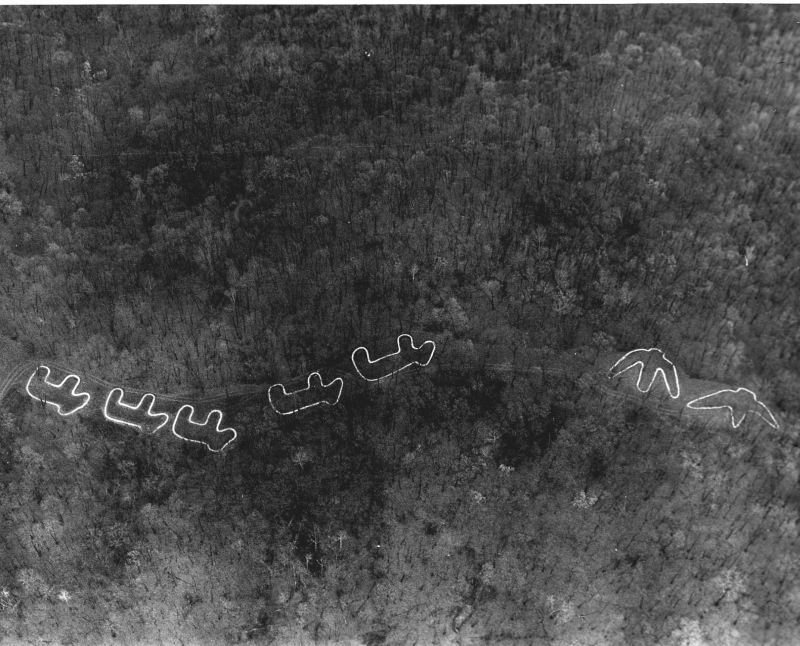
smithsonianmag.com 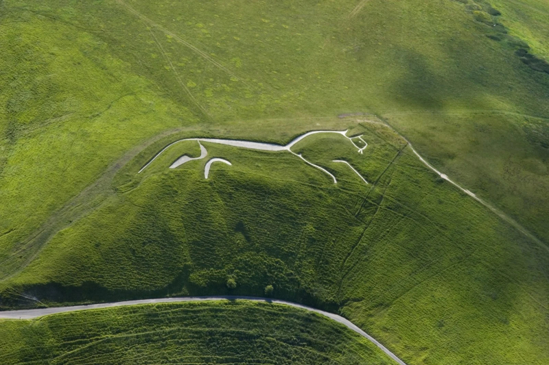
smithsonianmag.com -
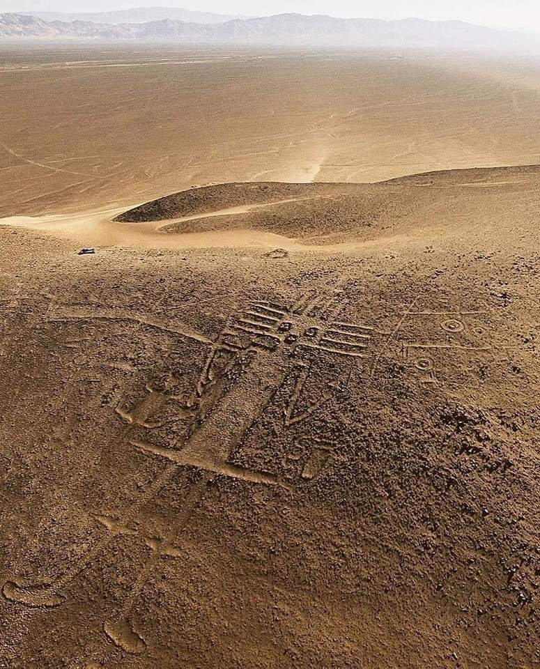
Paracas Candelabra is one of the most Remarkable Geoglyphs. Although the Nazca Lines are the most well-known geoglyphs in the world, they are not the only ones in Peru or even the Nazca region. Paracas Candelabra is a big image that looks like a trident with curly, almost cactus-like extensions sprouting from it. The geoglyph is 595 to 800 feet long, carved into the side of a hill at an average depth of two feet, and may be seen for up to 12 miles out to sea. The geoglyph was created around 200 B.C.E., according to radiocarbon dating.
What the Candelabra represents is debatable. Some archaeologists believe it represents one of South America's gods, while others say it represents Jimson Weed, a hallucinogenic plant. Residents of the Paracas region are supposed to have traveled up the coast to what is now California in ancient times to collect the weed.
Some inhabitants believe the Candelabra is a three-pronged candlestick holder or a cactus. Still, the area has long been a port for seafaring passengers, and some speculate that one of those sailors may have carved the Candelabras into the side of the hill during a layover, but no one is positive.
Location: the Paracas Peninsula at Pisco Bay in Peru
Date: N/a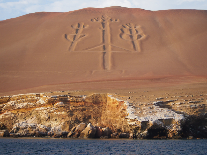
insightguides.com -
The Blythe Intaglios are a mystery, not only because archaeologists disagree on how old they are, but also because no one knows who created them. The geoglyphs look like ancient cave paintings etched into the dirt when viewed from a helicopter. The majority of them show a solitary person surrounded by figures depicting diverse animals such as horses and serpents. They are the only geoglyphs in this portion of North America and cover a bigger area than the Nazca lines.
Archaeologists and Chemehuevi Native Americans who dwell on the land have various opinions about what the glyphs symbolize. Archaeologists believe they were etched into the earth between 3,000 and 10,000 years ago to portray strong native American chiefs, however the Chemehuevi believe they have been a part of the land since "forever" and that the combined geoglyphs convey the story of their creation myth.
The Blythe Intaglios are said to have been created by scraping away at the darker top layers of earth, revealing lighter dirt beneath. One of the oddities of these geoglyphs is that many of them depict horses, which makes dating them difficult. Archaeologists have provided several possibilities here. One theory is that the glyphs were created after the Spaniards arrived in the Americas in the 1500s, bringing with them European horses. Another possibility is that the geoglyphs date back more than 10,000 years, before the North American horse became extinct. The third is that North American horses did not become extinct when people think they did, but rather served as a source of food for aboriginal Americans rather than a vehicle of transportation.
Location: near Blythe, California, in the Colorado Desert
Founded: First recorded 1932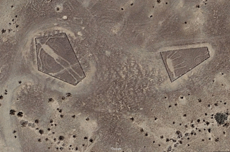
ancient-origins.net -
NASA began investigating a series of massive geoglyphs in Kazakhstan in 2015. They also told the astronauts on board the International Space Station to take photos of the area. The oldest glyphs date back approximately 8,000 years and vary in size and design. Some seem as enormous circles made up of smaller circles, while others are as massive as an aircraft carrier or large enough to contain multiple aircraft carriers.
Archaeologists have been compelled to reevaluate when humans got the ability to organize massive, complex enterprises like this. One of the mysteries surrounding the Neolithic markings is that many of them would have needed the Stone Age people who made them to dwell in the area far longer than archaeologists believe.
These shapes are squares, rings, and three others. The composite figures range from slightly under 90 m in length to over 400 m in diameter. Besides being made of earth dug out and piled up, some of the geoglyphs are made by placing stones next to each other. Some of the large shapes have been given names, including Bestamskoe Ring, Ushtogaysky (or Ushtogay) Square, Turgay triradial swastika, Large cross Ashtasti, Ekedyn cross, Ashutasti ring, Kyzyloba line, Koga cross, and Shili square.
Date: 2015
Location: the Turgai Trough area of Turgai in northern Kazakhstan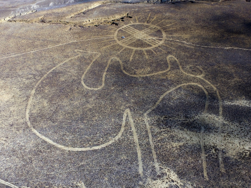
nationalgeographic.org -
This massive stick figure in the shape of a Horse is the size of a football field and can be seen from up to 20 miles away. It has endured for 3,000 years due to a recurring tradition known as "chalking day," in which groups of people are given hammers and buckets of chalk and assigned certain places inside the horse's shape. Those employees pound and shatter the chalk into paste, illuminating the white stony channels within the horse and maintaining the oldest hill sculptures in England.
The cleaning is overseen by the National Trust, a conservation organization that ensures the horse's natural shape is perfectly preserved. Given the age of the geoglyph, experts believe the trenches that form the horse's figure were dug with antler picks and wooden spades. And, like many other geoglyphs around the world, no one knows why it was built or how the ancient people who dug it up knew how it would seem from afar.
One feature of White Horse Hill that strikes out is how readily it may erode. The horse, unlike the Nazca Lines, requires ongoing maintenance. It's unclear why its designers chose such an unsafe location for the horse, but archaeologists believe it was done on purpose.
Date: N/a
Location: Oxfordshire, England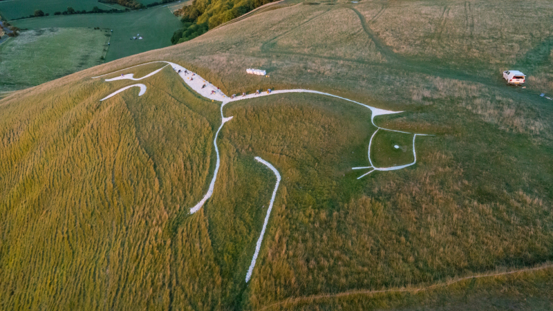
english-heritage.org.uk 
english-heritage.org.uk