Top 13 Stone Age Mysteries

The Stone Age is one of history's most enigmatic epochs. Archaeologists and scientists have been studying it for centuries, yet many questions remain ... read more...unresolved. There are numerous Stone Age mysteries that will astound you, ranging from enigmatic monuments to unexplainable items. Here is a list of the top 13 Stone Age Mysteries that you need to know about.
-
One of the top ten Stone Age mysteries is the identity of the Denisovans. A team of Russian archaeologists and geneticists found the Denisovans, an ancient human species, in 2010. This species' remains were discovered in the Denisova Cave in the Altai Mountains of Siberia, Russia. The Denisovans were unique from Neanderthals and modern humans, according to mitochondrial DNA analysis from a finger bone unearthed from the cave. In addition to their distinct DNA, the Denisovans possessed physical traits that distinguished them from other hominids, such as bigger teeth and a sturdy frame.
Little is known about this enigmatic species. The only other known specimens are two teeth discovered in a cave in Siberia and a lower jawbone from Tibet. Because of this dearth of evidence, some scholars argue that the Denisovans were a Neanderthal branch or maybe an extinct subspecies of contemporary humans. The Denisovans will remain a mystery until additional proof is unearthed. For the time being, they remain one of the more enigmatical aspects of the 10 Stone Age mysteries.
Date: Early to Middle Paleolithic period
Location: all over Asia

newscientist.com 
newscientist.com -
How did the Denisovans, an ancient kind of human, come to Asia is one of the top 10 Stone Age Mysteries that researchers continue to puzzle over. The Denisovans are thought to have existed roughly 50,000 years ago during the Paleolithic Era. Scientists have yet to address the question of how this species got to Asia, despite the fact that humans are thought to have developed in Africa.
According to research, the Denisovans may have journeyed via South East Asia before settling in India and Tibet. While some scientists believe the Denisovans traversed a land bridge from Siberia to India, others suggest that the land bridge was only open for a short period of time.
The ten Stone Age Mysteries surrounding the Denisovan migration remain unanswered. Recent discoveries, such as old remains and artifacts, have thrown more information on these ancient humans' lifestyle, although many specifics of their life and voyage remain unknown. Scientists anticipate that future research into ancient DNA will reveal more information about how these ancient humans dispersed over the world.
Date: Early to Middle Paleolithic period
Location: all over Asia
sciencefocus.com 
sciencefocus.com -
The 2012 discovery of 14,000-year-old bones belonging to a mysterious pre-modern human species in China's Maludong (Red Deer Cave) intrigued the scientific community. Archaeologists speculated at the time that the bones belonged to an unknown new species or a very early and primitive-looking group of modern people who came to the area around 100,000 years ago. The "Red Deer Cave People" are still a mystery because it was previously considered that the oldest pre-modern humans on mainland Eurasia—the Denisovans of Siberia and the Neanderthals of Europe and West Asia—died out around 40,000 years ago, shortly after modern humans arrived.
This finding implies that a pre-modern species coexisted with modern humans on mainland East Asia at some point in the past. These ancient humans, or more precisely, their remains—which are so close to them but so physically distinct—are so much younger than Neanderthal forebears that it raises some critical considerations. Were they really a distinct kind of human? What happened to them, assuming that's the case? What caused their extinction? What exactly was their manner of life? And how did they interact with forefathers?
Dated: between about 17,830 to c. 11,500 years ago
Location: Red Deer Cave, Maludong, Chinese
en.wikipedia.org -
The Shigir Idol was discovered in 1894, deep within a peat bog in Russia's Ural Mountains. It dates back to the early Holocene epoch, also known as the "Age of Man," and is 12,500 years old, making it twice as old as Egypt's iconic pyramids. The idol itself is a preservation miracle. It was discovered in fragments and stood roughly 9 feet (2.75 meters) tall after being repaired. It was carved from the wood of a 156-year-old Larch tree. However, according to the sketches of archaeologist Vladimir Tolmachev, it was over twice that height at one time!
The huge artwork features seven faces: a three-dimensional face on top, and six more carved on the idol's torso. Alongside the beautifully carved faces are a series of abstract designs such as chevrons, herringbone, and diagonal and horizontal lines. Experts have yet to decode the phrase that was precisely carved onto the surface of the sculpture. Nonetheless, it is considered that the sculptor's geometric designs have a special purpose. According to some ideas, the lines represent the boundaries between the spiritual and physical worlds, and they may resemble a graphical map or have some connection to the deities of the time.
Discovered: January 24, 1894
Location: Shigir, eastern edge of the Central Urals, near Kirovgrad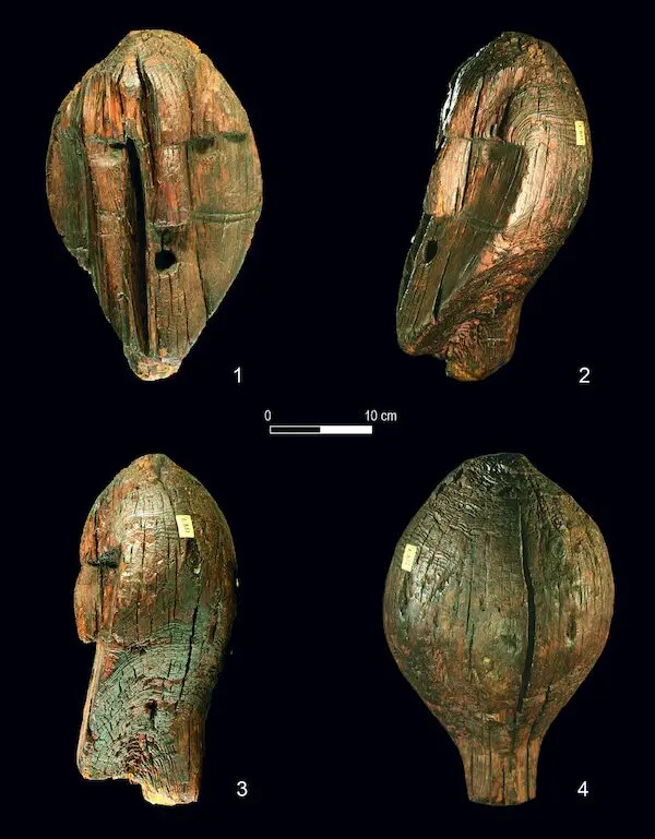
nytimes.com -
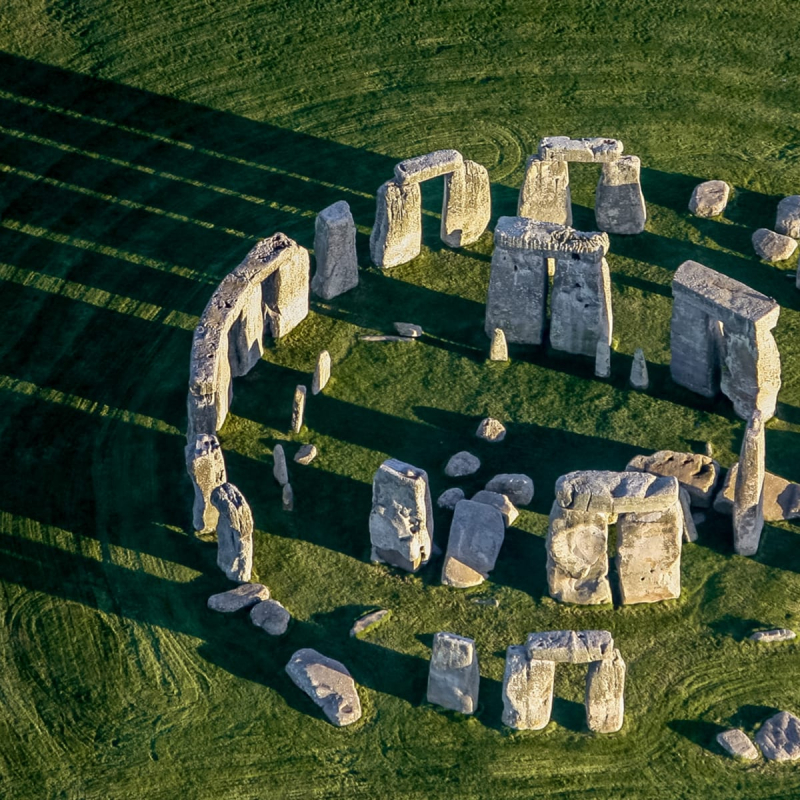
Stonehenge, a Stone Age engineering masterpiece built before the pyramids, has stood the test of time for millennia. Each of the 80 megaliths, some of which stand taller than 23 feet (7 meters), weighs more than 20 tons. Stonehenge's construction began around 3100 BC. Stonehenge currently represents only a small portion of the original site. But what motivated the ancient people to create these gigantic boulders in the midst of nowhere in the United Kingdom? According to London archaeologist Mike Parker Pearson, up to 10% of what is now the island of Great Britain visited the site to worship the gods. The discovery of 80,000 animal bones, which may have been used as sustenance or as sacrifices to the gods, lends credence to this theory.
The most prevalent theory is that Stonehenge served as an observatory, with the rising sun shining directly through the complex's core at the equinox. Others suggest it was used for pagan ceremonies and burials. The only thing they know for certain is that this was a historically significant site. There are absolutely no other theories that can justify the enormous amount of effort that went into building the magnificent structure.
Constructed: from around 3000 BC to 2000 BC
Location: Salisbury Plain in Wiltshire, England
history.com -
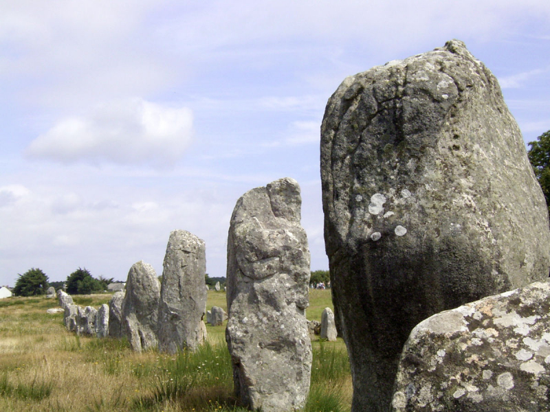
Hundreds of megalithic sites dot the landscape around Carnac on the south coast of Brittany, France. People in the Carnac region began creating these megaliths around 5000 BC. Because of the sheer size and amount of stones, archeologists believe the area must have had a massive, vibrant, and well-organized civilisation for the next 2000 years. Because it was shielded by the Quiberon Peninsula and had multiple fresh-water springs, it would have been an ideal location for hunting, fishing, and gathering shellfish and berries. It is claimed, however, that the emergence of agriculture, which entailed caring for domestic animals and cultivating crops, liberated people, allowing them to create these vast complexes. But why did they construct it?
Megaliths, dolmen (stone tunnels), and tumuli (dolmen covered by enormous mounds), as well as single-standing stones, have been recognized as burials or could be related with graves (menhirs). The purpose of the long stone lines (alignments), stone circles (cromlechs), and the majority of the menhirs, on the other hand, has been lost to the centuries. Some believe these are ancient farmers' observatories or calendars used to understand the seasons and when to cultivate or harvest their crops. Priests may have used them to prophesy horrible catastrophes such as solar and lunar eclipses.
Dated: as early as 4500 BC.
Address: Lieu-dit le Ménec, 56340 Carnac, France
en.wikipedia.org -
A one-of-a-kind and intriguing megalithic building is located in a seldom-visited and uninviting region of Morocco, not far from the Atlantic coast, but far from major tourist spots and adequate highways. The Mzora stone ring (also known as Msoura/Mezorah) is the world's largest stone ellipse. It's around 6.8 miles (11 kilometers) from Asilah and 6.7 miles (27 kilometers) from ancient Lixus's spectacular, overgrown ruins. Mzora is relatively unknown in history, however Plutarch may have mentioned it in the first century A.D. in his Life of Sertorius.
The 10,000-year-old site has 168 surviving stones out of a total of 175 that were once expected to exist. The tallest of these stones is nearly 16.5 feet (5 meters). The only professional assessment of the location was conducted in the 1970s by the Woods Hole Oceanographic Institute in Massachusetts. Mzora was discovered to be not only unusual in terms of itself, but also to have implications for the history of megalithic sites in Britain as a result of that survey.
Mzora appears to have been erected by the same culture that built megalithic monuments in Ireland, France, and Britain, as the site is aligned with Stonehenge and Carnac and is firmly tied to the European continent. The ellipse was created using a Pythagorean right-angled triangle with the ratio 12-35-37. The Sands of Forvie and Daviot rings, which are among the 30 good examples of British stone ellipses that have survived, were made using the same procedure.
Dated: to the 4th or 3rd century BC
Location: Northern Morocco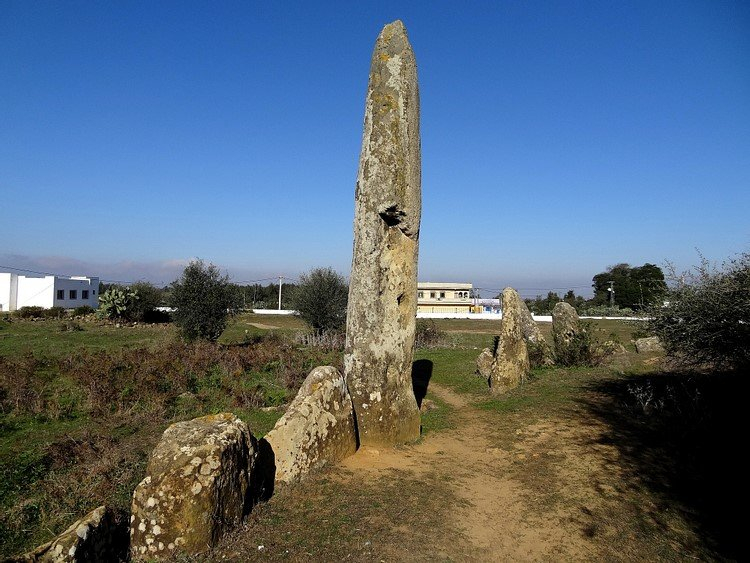
en.wikipedia.org -
People first settled on the Maltese islands around 7,000 years ago, most likely from Sicily. However, nothing is known regarding the travels of prehistoric peoples around the Mediterranean. Then, approximately 3,400 BC, construction of megalithic structures unlike any other in the world, dating back to before the Great Pyramid and Stonehenge, began. The temples were constructed over a thousand years, with distinct stylistic stages within the era, and thirty locations still remain today.
Malta also has the Hal Saflieni Hypogeum, which is one of the best preserved in the world. A hypogeum is a rock-carved underground chamber system. Several temples are thought to have had such structures beneath them, although they have yet to be unearthed. The Hal Saflieni Hypogeum is divided into three levels of subterranean rooms, pits, and galleries. The grade of rock-cutting varies from rough-hewn regions to highly finished exteriors.
The hypogeum also possesses unusual acoustic qualities, as sound echoes last an unusually long time and ricochet throughout the entire structure. Several acoustic investigations have been undertaken over the years, with a particular focus on the "oracle room," which contains an oval wall niche that produces an especially powerful echoing sound. It's worth observing that as one walks deeper into the oracle room, the painted "disks" grow larger, reaching their apogee at the wall niche where the ceiling painting abruptly terminates. This most likely proves that chanting was part of the site's archaic festivities, yet it remains another prehistoric wonder from Malta.
Constructed: 3600 TCN
Location: Malta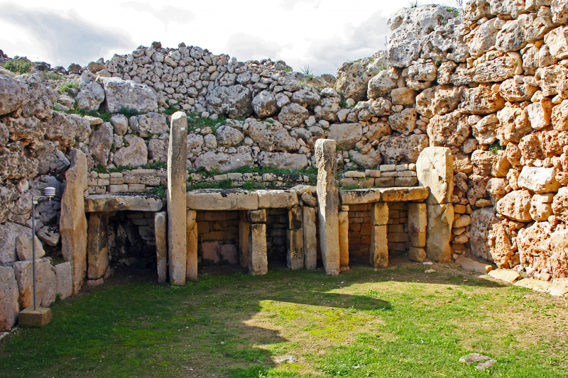
vi.wikipedia.org -
Since its discovery by archeologists some 60 years ago, one of the first stone monuments in human history, a tower unearthed within the ancient settlement of Tel Jericho, has produced a range of theories as to why it was created. The Tower of Jericho was built exactly adjacent to the Wall of Jericho around 8000 BC. The wall was discovered in 1907, but the tower was not uncovered until 1952.
The people who built this tower were established hunter-gatherers on the cusp of converting to agriculture around 11,000 years ago. They couldn't simply pack their belongings and leave in times of crisis or uncertainty like their forebears could. Some archeologists assume that the tower's construction was motivated by the residents' primordial concerns and cosmological ideas. Others have speculated that the tower and the wall next to it were built as defenses to protect the village, as a geographical marker, or even to symbolize affluence.
Two Tel Aviv University archeologists recently proposed a fresh proposal. After watching how the sunset on the summer solstice, the longest day of the year, interacts with the tower and the landscape around it, they feel the 28-foot (8.5-meter) tower symbolizes power and force. As the solstice sun descended before swallowing the settlement, the shadow of a hill to the west fell exactly on the Jericho Tower, signifying that the monument and the beginning of longer nights were linked.
Constructed: 8000 BCE.
Location: West Bank, Palestine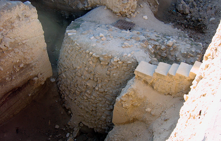
smarthistory.org -
Nabta Playa is a one-of-a-kind Nubian Desert site located about 62 miles (100 kilometers) west of Abu Simbel in southern Egypt, featuring hundreds of prehistoric tumuli, stelae, and megalithic constructions. These are the ruins of a well built urban city that arose approximately 11,000 years ago. Underground tombs, stone circles, gigantic stone slabs, and 8,200-foot-long (2,500-meter) extended rows of stelae were among the megalithic monuments constructed by the population. The megalithic monuments of Nabta Playa are among the world's oldest, dating back many millennia before Stonehenge.
Among the most significant structures in Nabta Playa is a stone circle that scientists have determined to be the world's earliest known megalithic astronomical alignments. The stone circle, which dates back at least 7,000 years, was constructed as a prehistoric calendar to commemorate two significant celestial events: the summer solstice, which is associated with the beginning of summer rains, and the constellations in the night sky, which they used to navigate across the desert.
What happened to the people of Nabta Playa remains unknown. Some argue that climatic change in the surrounding environment led the people of Nabta Playa to disperse. They most likely moved south into Nubia (modern-day Sudan) and then north into Egypt. It is worth mentioning that their flight would have taken place in the years preceding the rise of the first pharaohs, prompting some to suggest that Nabta Playa is the genuine genesis of Ancient Egyptian civilisation.
Dated to circa 7500 BC
Location: the Nubian Desert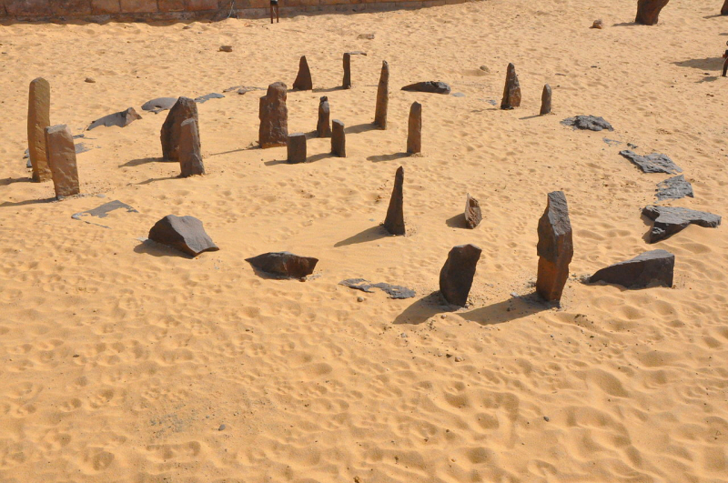
kyluc.vn -
Egypt's national symbol and one of the world's most famous sights is the Great Sphinx of Giza, a giant stone figure with the body of a lion and the head of a man wearing the pharaoh's crown. Despite its fame, Egyptologists, archeologists, geologists, and others continue to discuss the Sphinx's unsolved "riddle": How old is it exactly? According to common belief, the monolith is around 4,500 years old and was created for Khafre, a Fourth Dynasty king who reigned between 2603 and 2578 BC.
However, not everyone believes that the Sphinx was created for Khafre. Despite the Sphinx's location within the pyramid complex typically regarded as Khafre's, no contemporary inscriptions link him to the statue, according to some Egyptologists as early as the mid-nineteenth century. Various researchers have credited the Sphinx to Khafre's father, Khufu, as well as Djedefre, another of Khufu's sons, over time. A new theory suggests that the statue's origins date back considerably further, to roughly 9,000 years ago. Advocates of this idea point to significant limestone erosion near the top of the Great Sphinx, stating that the region last experienced enough rainfall to cause this level of deterioration in 7000 BC.
Date: 4,500 years old
Location: Giza, Egypt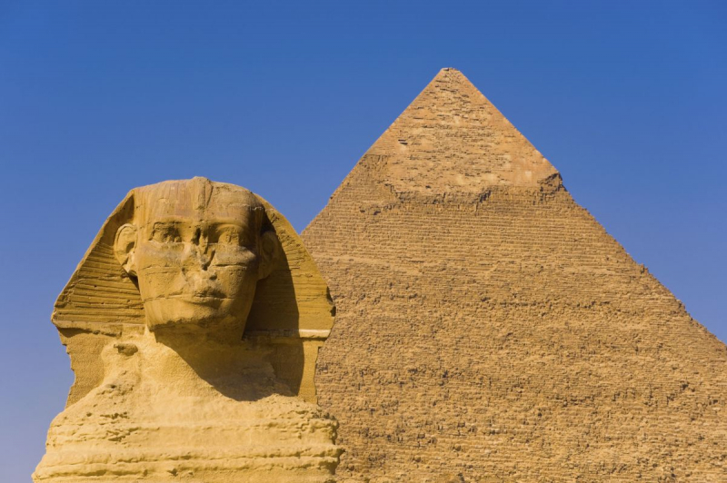
history.com -
No Stone Age list would be complete without mentioning Göbekli Tepe, commonly regarded as the world's first temple. Göbekli Tepe is in southeastern Turkey, approximately 55 miles (88 kilometers) east of the upper Euphrates. The 12,000-year-old site's discovery in 1994 sent shockwaves through the archeology world, putting into question a long-held idea that organized religion emerged only after tribes embraced agriculture. Archeologists became convinced during the early digs that the site was a ceremonial center, likely a burial or death cult complex, rather than a community.
Recent findings, such as evidence of homes, a massive receptacle and pathways for rainwater gathering, and hundreds of milling tools, are rewriting prehistory yet again. Researchers have also developed a computer technique to track the site's architectural architecture, notably three of the complex's truly huge round structures. They discovered that the pillars were purposefully put in their exact placements. They discovered that the design of the site is characterized by symbolic and geographical hierarchical layers that reflect changes in the spiritual realm as well as social structures of the period.
This discovery is significant since architectural design methods such as floor plans and geometry were supposed to have originated much later in history. To put things in perspective, Göbleki Tepe was built 6,000 years before Stonehenge, and the meaning of its sculptures, architecture, and ultimate purpose is still unknown. Of course, this adds to the mystery and appeal of the Göbekli Tepe. Every new discovery alters knowledge of the place and the history of humanity.
Abandoned: 8th millennium BC
Address: Örencik, 63290 Haliliye/Şanlıurfa, Turkey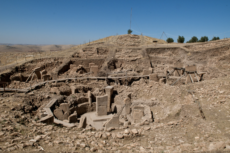
en.wikipedia.org -
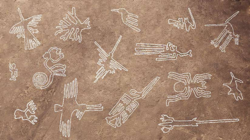
Archaeologists and historians have long been fascinated by the Mysteries of the Stone Age. Many of these issues remain unresolved, ranging from the advent of Neanderthals to the evolution of writing and early art. The genesis of the Nazca Lines is one of the most mysterious. For generations, experts have been mystified by this enormous network of geometric lines and shapes in the Peruvian desert. What are they and how did they come to be?
The Nazca Lines are thought to have been created between 400 BCE and 600 CE by ancient Native Americans. The lines are drawn on the desert's surface and range in length from a few meters to over a kilometer. They represent hundreds of diverse designs, including animals, plants, geometric forms, and even The Astronaut, a humanoid figure. Some academics believe the Nazca Lines were employed for astronomical observations or religious rites. Others feel they served a more practical role, such as identifying boundaries or pathways.
The mystery surrounding the Nazca Lines is threefold. First, how did ancient peoples draw such exact lines? While some believe the lines were drawn by hand with wooden sticks, others say massive equipment such as ropes or tree trunks were utilized. However, no evidence supporting either theory has been discovered. The second wonder is how people were able to accomplish such huge size without the use of modern instruments such as airplanes or satellites. Some experts have proposed that ground-level markings such as mounds or flags may have assisted the makers in visualizing their work from afar, although this is currently just a speculation. The Stone Age mysteries remain unresolved, and people may never know for definite how the Nazca Lines were created. It is apparent, however, that whoever constructed them possessed an incredible level of engineering skill and technological expertise.
Date: between 200 BC and 600
Location: the desert of Nazca, Peru
machutravelperu.com