Top 20 The World's Scariest Bridge

When mankind started building bridges, nobody could imagine the heights they would reach. But human-made the impossible possible and built bridges in the most ... read more...unimaginable places. Some of them are so dangerous that the mere thought of walking these bridges would send chills down your spine. Go on to explore Toplist.info the scariest bridges around the world and go through them to feel the fear right away!
-
A cầu khỉ (monkey bridge) in Vietnam is a handmade bamboo or wooden passway across a stream or gully. The monkey bridge, as a uniquely Vietnamese traditional symbol, was the inspiration for the title of American author Lan Cao's novel Monkey Bridge.
It is also called a coconut bridge (if made of the coconut tree) or a bamboo bridge (if made of bamboo). These bridges, with or without handrails are very difficult and dangerous for those who are not accustomed to them. Those familiar with them have been known to carry on their shoulder 20–50 kg while on the bridge.
Monkey bridges are also very popular in the Mekong Delta because there is a system of streams. In coastal areas of the Red River Delta in northern Vietnam, such as Giao Thuy, Hai Hau (Nam Dinh Province), or Tien Hai (Thai Binh Province). There are also footbridges, mainly for passersby to take care of rice in the fields. Before 1960, footbridges were also very popular in Northern Vietnam. They would naturally follow the path of foot traffic, the bridges wading out of the water stream.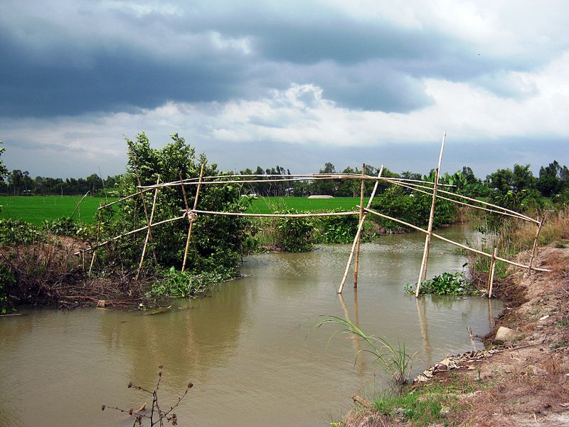
Monkey bridges 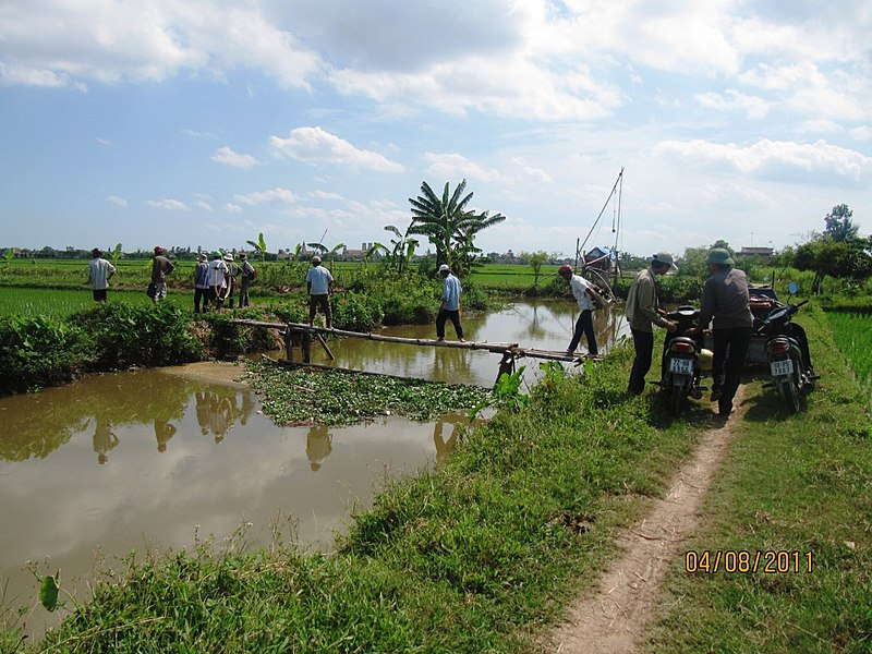
Monkey bridges -
This suspension bridge locates in the Montenegro Rainforest, possibly one of the most beautiful and diverse rainforests in the world. The bridge is made of wood and is missing many of its rungs, leading to a very awkward crossing with any wrong step leading to a potentially unfortunate resting place on the shrubs below.
From bats and migratory birds to a vast array of reptiles, Costa Rica is well known for its incredible biodiversity. Just northwest of San José, you will be able to find a 26,000-acre and get lost in the infinite green surroundings that are breathtaking.
In the middle of the rainforest canopy, Montenegro Rainforest Bridge in Costa Rica allows you to experience the dense & diverse forest. But be careful, the bridge might just be missing a plank or two and might be enough to give you plenty of problems. Six of these footbridges interconnect to lead Costa Rica climbers along a 984 feet path above the Monteverde Rainforest. With plenty of canopies and a moisture-rich environment, keep your eyes out for jaguars and snakes as you swat the bugs away.
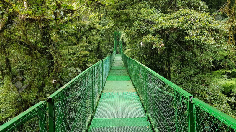
Montenegro Rainforest Bridge, Costa Rica 
Montenegro Rainforest Bridge, Costa Rica -
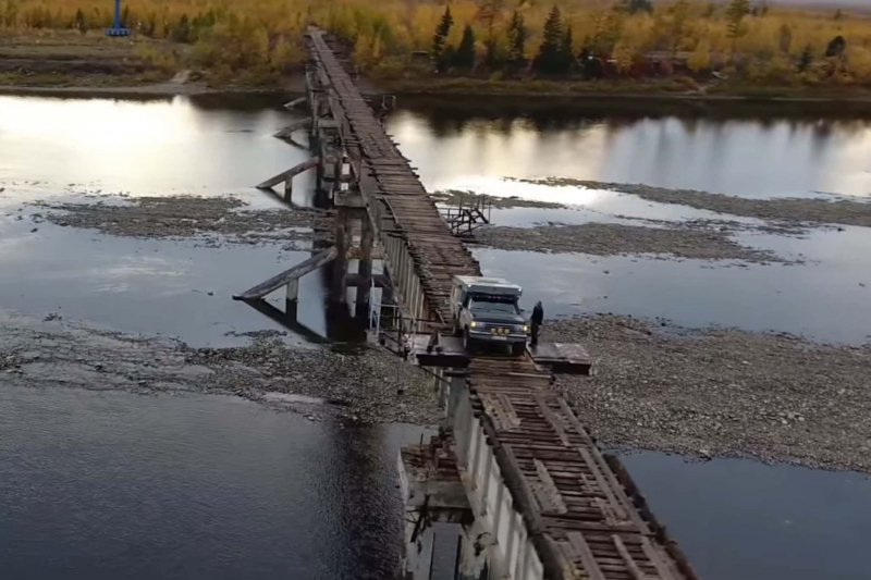
Crossing the Vitim Rivier in Siberia is the aptly named Vitim River Bridge, a disused railroad crossing built in the early 1980s that is now used by automobiles and motorcycles. With a drivable surface made of railroad ties and reportedly not much more than six feet wide, it is a sketchy drive, to say the least.
Fully frozen for most of the year and without any side-rails, Vitim River Bridge has only been crossed successfully by a handful of people in Russia's history. Though scary, a lot of adrenaline junkies come from across the globe to challenge themselves by trying to cross the bridge.
Vitim River Bridge was originally built in 1982 for trains traveling on the Baikal-Amur Mainline. It was abandoned due to poor construction techniques that left it unable to cope with the river's current in the spring, and chunks of ice in the winter. Another railway bridge was built roughly a quarter-mile up-river to replace it, and the original bridge's life as a light-vehicle crossing began.
The structure, also known as the Kuandinsky Bridge, was never designed for this, of course. The wood surface is constantly rotting away due to the Siberian weather and it is slick in the winter thanks to snow and ice. It is still used with relative frequency though, with some crossing it as part of a long adventure, and others crossing regularly out of necessity.
Vitim River Bridge 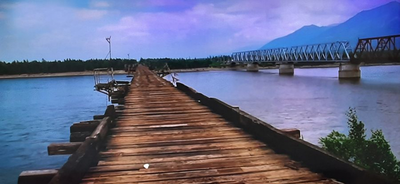
Vitim River Bridge -
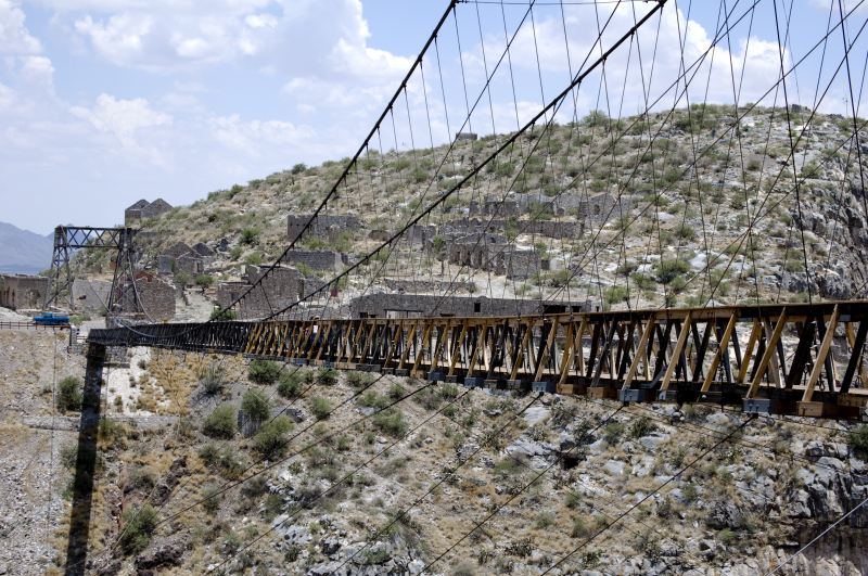
The Ojuela Bridge or the Mapimi Bridge (Puente de Ojuela, Spanish name) is a suspension bridge located in Mapimí, in the Mexican state of Durango, at the site of the Ojuela Goldmine. The Ojuela Bridge was designed by Wilhelm Hildenbrand and built by the firm of John A. Roebling Sons Company, New York. Completed in 1898 the bridge was restored as a tourist attraction in 1991.
The bridge has a main span of 271.5 meters and the distance between the pylons is 315.5 meters. Currently, Ojuela Bridge is only used for pedestrians. Used specifically for mining, this bridge has been left in ruins and can only be used by pedestrians. This is because if cars or trucks pass through the bridge, they might not make it to the other side.
The road leads to the Ojuela Bridge, also known as the Mapimi Bridge. It is one of the world’s scariest bridges. It was designed by the same people as the Brooklyn Bridge and is considered one of the most dangerous and mysterious places on the planet. The Puente de Ojuela is a suspension bridge leading to a ghost town. It is 2 feet wide and steel cables have been added for safety over two towers.
Puente de Ojuela 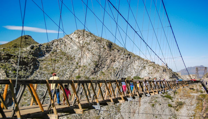
Puente de Ojuela -
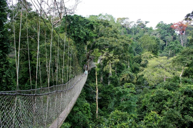
Undoubtedly, this may come across as an improbable adventure. However, it is a thrilling experience that Amizade volunteers get to frequently enjoy when taking canopy walks through Kakum National Park during volunteer programs in Ghana.
The Canopy Walk at Kakum National Park is made up of 7 bridges that extend a length of over 330 meters and rest over 30 meters above the forest floor. It was first constructed by a Canadian non-governmental organization to trap parrots in the forest canopy as a source of income. Across over 1,000 feet of walkway, the bridges look as though they are constructed like a traditional rope bridge made from the materials of the forest. However, the sturdy spans are made of wire rope, aluminum, and wooden planks, and even have safety netting to keep people from plummeting off the trail.
Today, Canopy Walk is a majority tourist attraction in the area and has become one of the most significant drivers for economic development in the region. The appeal of the Canopy Walk is the fascinating viewpoint that it provides. Instead of a typical ground tour of the forest, one gets to trek along the narrow rope bridges several stories above the forest floor and gaze at the breathtaking scenery from a bird’s point of view. This unique experience has sparked a significant amount of tourism in the area, which has subsequently enhanced economic development in the region.
Canopy Walk Bridge 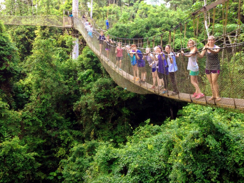
Canopy Walk Bridge -
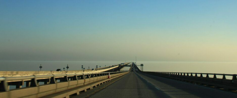
The Lake Pontchartrain Causeway is also known as The Causeway, is a fixed link composed of two parallel bridges crossing Lake Pontchartrain in southeastern Louisiana, United States. In 1955, the Louisiana Bridge Company was created to undertake the construction project. It took just 14 months to build the first two-lane span of the causeway. The longer of the two bridges is 23.83 miles (38.35 km) long. The bridges are supported by 9,500 concrete pilings. The two bridges feature a bascule, which spans the navigation channel 8 miles (13 km) south of the north shore.
The Lake Pontchartrain Causeway is so long that motorists lose sight of land for an eight-mile stretch, and drivers have been known to freeze out of some kinds of false seaborne fear, at which point the police have escorted them off the bridge. Babies have been born on the causeway when their mothers failed to make it to the hospital on the other side. And an airplane once ran out of gas over the lake, eventually landing safely on the bridge.
A decade after the completion of the first bridge, daily traffic had surpassed 5,300 vehicles. Plans were made to expand the causeway by building a second two-lane span parallel to the original. The second bridge was opened in 1969, separated from the original by about 84 feet. The second span was only about 50 feet longer than the original, but it was enough to finally catch the attention of the Guinness Book of World Records (first published in 1955). The Lake Pontchartrain Causeway was officially recognized as the longest bridge over water in the world, a record it held unchallenged until 2011.
Lake Pontchartrain Causeway 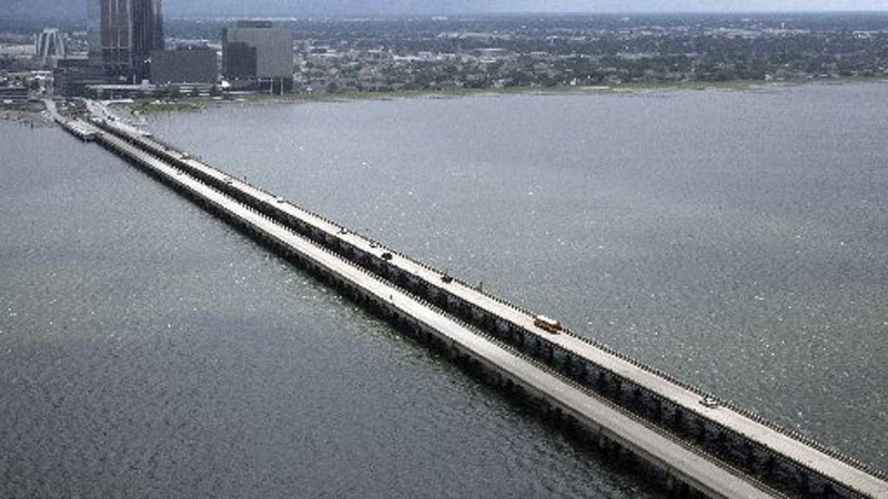
Lake Pontchartrain Causeway -
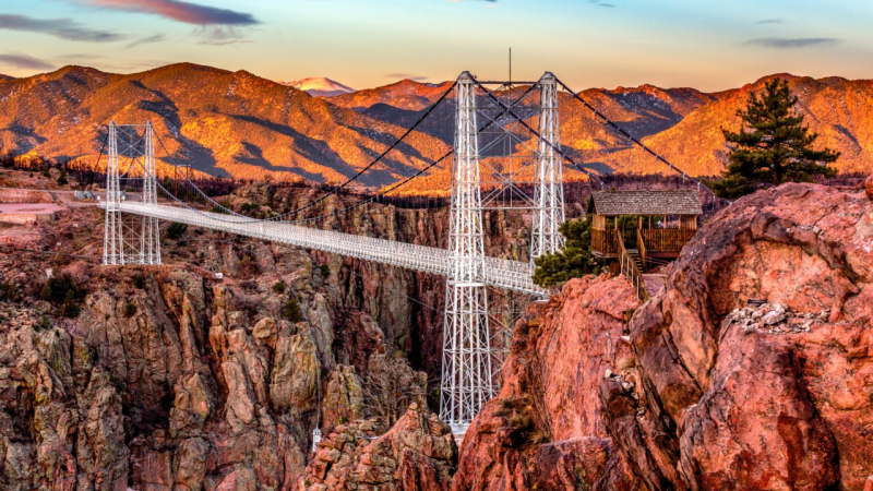
The Royal Gorge Bridge is a tourist attraction near Cañon City, Colorado within Royal Gorge Bridge and Park, a 360-acre (150 ha) amusement park located along the edge of the Royal Gorge around both ends of the bridge. The bridge crosses the gorge 955 feet (291 m) above the Arkansas River and held the record for the highest bridge in the world from 1929 until 2001
The main span of the Royal Gorge Bridge between the towers is 880 feet (268 m), the total length is 1,260 feet (384 m), the width is 18 feet (5.5 m) and the towers are 150 feet (46 m) high. The steel base structure is covered with 1292 wooden planks. The bridge was built in six months between June and November 1929 for $350,000. In 1931, the Incline Railway, or simply the Incline (also known as a funicular), was added beside the bridge to reach the bottom of the gorge. In the 1950s, a miniature railroad was built by the edge of the gorge and an aerial tram was opened in 1969.
The road leading to the Royal Gorge Bridge from U.S. Route 50 continues on the Southside of the gorge eventually re-connecting with Route 50. However, all visitors are required to enter and exit through the North park gate. The road on the south rim is blocked shortly beyond the bridge and all traffic must turn around. Passenger vehicles are allowed to cross the bridge, but only before park attractions open or after they close, with times depending on the season. Large vehicles such as trucks, RVs, and buses are not permitted to cross.
Royal Gorge Bridge 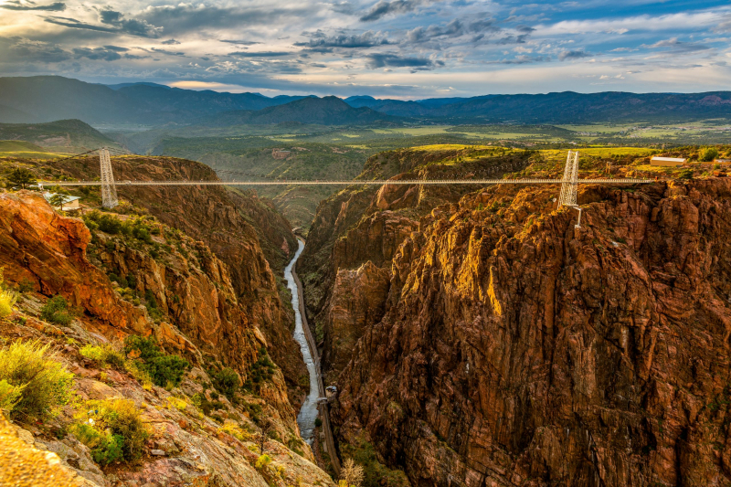
Royal Gorge Bridge -
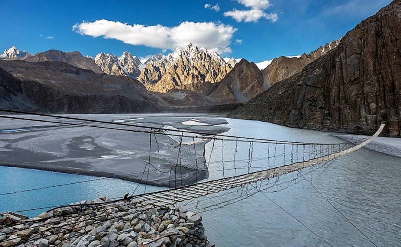
Hussaini suspension bridge crosses the lake Borit upstream of Hunza river in northern Pakistan. A 2,600 m altitude, in the region of Gilgit-Baltistan, is the world's most dangerous bridge. It is an important point of connection of the routes that go to the north of the country, belongs to the people of Pasu and other neighboring villages, and ends at the lake itself in Gilgit-Baltistan.
Since 1978 is relatively isolated by the lack of roads and infrastructure, the only possible way is through the mountains to Rawalpindi or traffic of aircraft but only for the richest people. Internal insulation between regions is offset by the construction of the Karakoram Highway, which crosses the region from outside. The view from the Hussaini-Borit Lake Bridge is picturesque, not to mention precarious and potentially lethal.
Crossing Borit Lake and the rapidly flowing Hunza River is particularly frightening, the reason for being named the world’s most dangerous suspension bridge and also the world's most attractive bridge. Hussaini Bridge is also one of the oldest bridges in Pakistan.
The truly death-defying thrills and fears when crossing this bridge where sudden gusts of winds can hit travelers off their feet to face to face with death. Despite its dangerous looks, the Hussaini is a relatively safe bridge. It has become something of a tourist draw, with hikers testing their nerves as they carefully work their way across.
Hussaini Hanging Bridge, Pakistan 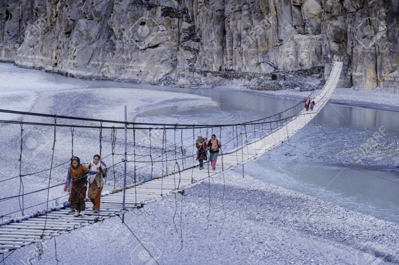
Hussaini Hanging Bridge, Pakistan -
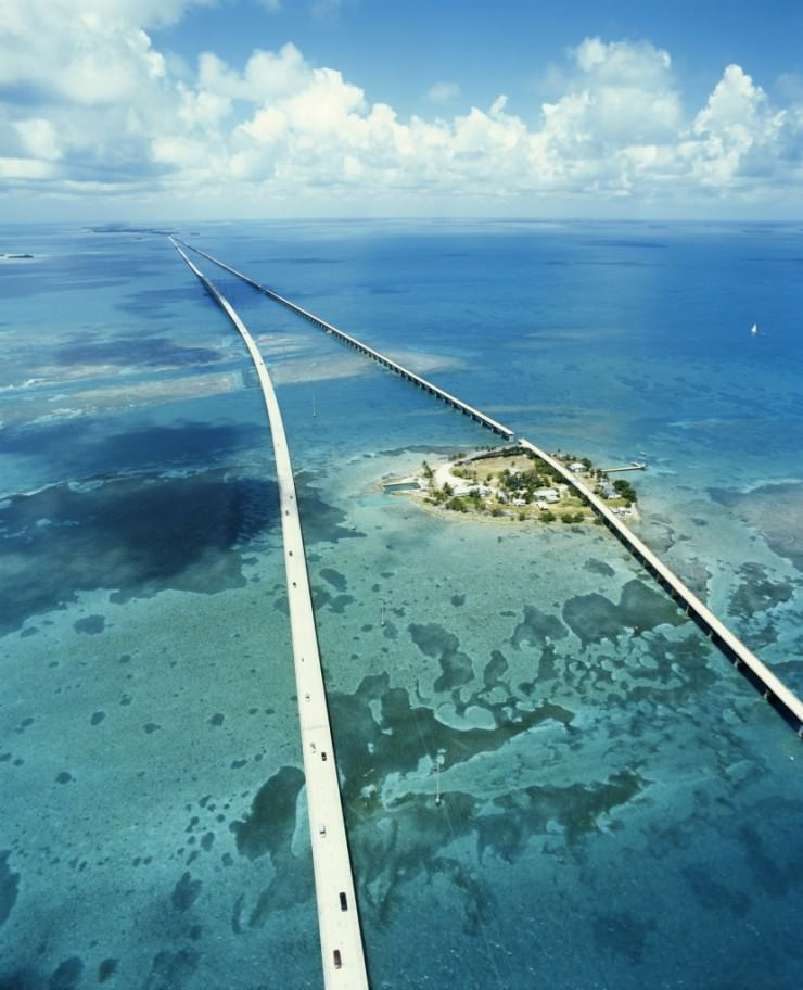
The Seven Mile Bridge is a bridge in the Florida Keys, in Monroe County, Florida, United States. It connects Knight's Key (part of the city of Marathon, Florida) in the Middle Keys to Little Duck Key in the Lower Keys. Among the longest bridges in existence when it was built, it is part of the Overseas Highway in the Keys, which is part of the 2,369-mile (3,813 km) U.S. Route 1.
There are two bridges in this location. The modern bridge is open to vehicular traffic; the older one only to pedestrians and cyclists. The older bridge, originally known as the Knights Key-Pigeon Key Bridge, was constructed from 1909 to 1912 under the direction of Henry Flagler and Clarence S. Coe.
It is certainly breathtaking and it has a fearsome reputation. Seven Mile Bridge itself does not seem that scary. But its position in the Florida Keys makes it a prime target for the region’s many hurricanes. Driving through this bridge can be an extremely daunting task. The current bridge is the second iteration. The newer bridge scrapped the swing span concept of the original instead of a sturdier 65-foot-high arch to allow boats to pass by. While it may be sturdier, we still would not want to be on it during a storm. It is one of the most spectacular bridges in the world.
It is quite a famous bridge that has appeared in a lot of movies, with a starring role in action thrillers like Licence to Kill, True Lies, The Haunted Mansion, Fast and Furious, Mission Impossible III, I Am Number Four, and Leverage. The Florida Keys’ Seven Mile Bridge looks as impressive on film as it does in real life.
Seven Mile Bridge 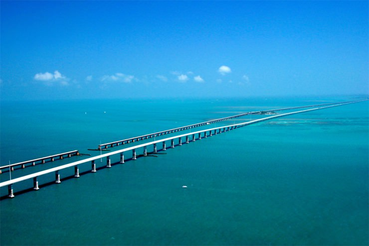
Seven Mile Bridge -
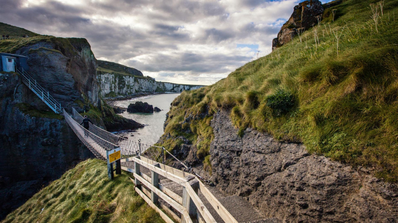
The Carrick-a-Rede Rope Bridge (locally pronounced carrick-a-reed) is a rope bridge near Ballintoy in County Antrim, Northern Ireland. The bridge links the mainland to the tiny island of Carrickarede. It spans 20 meters (66 ft) and is 30 meters (98 ft) above the rocks below. The bridge is mainly a tourist attraction and is owned and maintained by the National Trust. In 2018, the bridge had 485,736 visitors. The bridge is open all year round (subject to weather) and people may cross it for a fee.
Crossing the Carrick-a-Rede Rope Bridge is an exhilarating experience, high above the water and open to the elements. Thousands of people come every year to blow out the cobwebs, see beautiful coastal scenery, and spot rare wildlife. Pre-booking is essential. The National Trust limits the number of people who can cross the bridge at any given hour. Sway with the wind as you cross and take in the stunning views along the Causeway Coastal Route, best known as an outstanding area of natural beauty in Northern Ireland.
As a conservation charity, they are committed to preserving and protecting their special places and spaces for everyone to enjoy. This includes protecting ongoing conservation, managing health and safety, and trying to ease traffic congestion around the site.
Carrick-a-Rede Rope Bridge 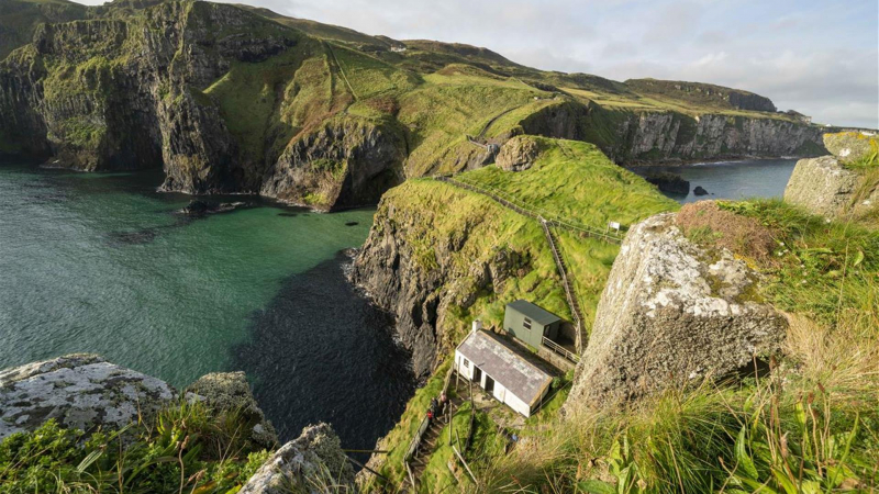
Carrick-a-Rede Rope Bridge -
The Storseisundet Bridge is the longest of the eight bridges that make up the Atlanterhavsveien ("The Atlantic Road"), the road connection from the mainland Romsdal peninsula to the island of Averoya in More og Romsdal county, Norway. The bridge sits on the border between Hustadvika Municipality and Averoy Municipality and passes through an archipelago as it links mainland Norway with the island of Averoy. It is one of the country's official national tourist routes.
Storseisundet Bridge is a cantilever bridge that is 260 meters (850 ft) long and with a maximum clearance to the sea of 23 meters (75 ft). It was opened on 7 July 1989, and it was a toll road until June 1999. Over the six years that it took to construct, workers struggled with the region's wild weather and were interrupted by twelve hurricanes. One hundred and twenty-two million Norwegian kroner were spent completing the project, seventy-five percent of which came from public grants. The rest of the funding was recovered with toll fees. The bridge was originally projected to recoup its investment in 15 years but was completely paid for in ten years.
The bridge is paved and was opened on 7 July 1989. It’s known for its sharp bends and rollercoaster-eques driving experience. It seems to have a different shape from whichever angle you view it which is, perhaps, what makes it so special. Drivers cannot see the abnormal curve when on the road. In fact, they cannot see the road on the other side of the curve at all. Storseisundet Bridge appears to disappear, and it looks like any car that attempts to cross it will simply fall into the water. This is obviously an optical illusion.

Storseisundet Bridge Storseisundet Bridge -
U Bein Bridge is a crossing that spans the Taungthaman Lake near Amarapura in Myanmar. The 1.2 kilometers (0.75 mi) bridge was built around 1850 and is believed to be the oldest and (once) longest teakwood bridge in the world. Construction began when the capital of Ava Kingdom moved to Amarapura, and the bridge is named after the mayor who had it built. It is used as an important passageway for the local people and has also become a tourist attraction and therefore a significant source of income for souvenir sellers. It is particularly busy during July and August when the lake is at its highest.
U Bein Bridge was built from wood reclaimed from the former royal palace in Inwa. It features 1,086 pillars that stretch out of the water, some of which have been replaced with concrete. Though the bridge largely remains intact, there are fears that an increasing number of the pillars are becoming dangerously decayed. Some have become entirely detached from their bases and only remain in place because of the lateral bars holding them together. Damage to these supports has been caused by flooding as well as a fish breeding program introduced into the lake which has caused the water to become stagnant. The Ministry of Culture’s Department of Archaeology, National Museum, and Library plan to carry out repairs when plans for the work are finalized.
From 1 April 2009, eight police force personnel have been deployed to guard U Bein Bridge. Their presence is aimed at reducing anti-social behavior and preventing criminal activities, with the first arrest coming in September 2013 when two men were reported for harassing tourists.
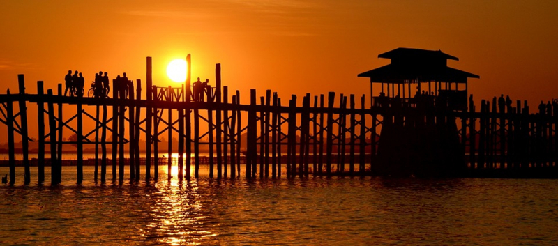
U Bein Bridge, Myanmar 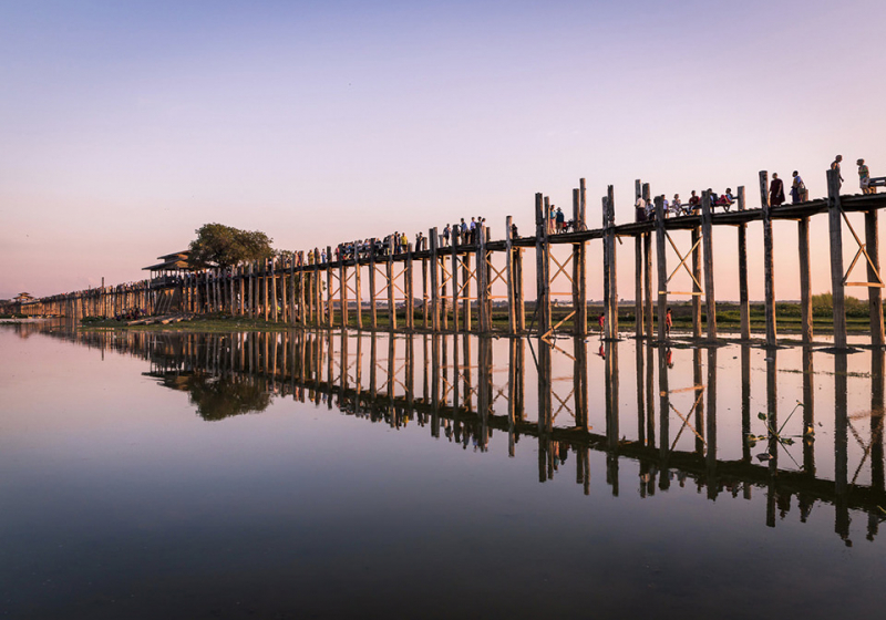
U Bein Bridge, Myanmar -
Huangshan or Yellow Mountain is a mountain range in eastern China and a well-known iconic place in that region. The whole range consists of granite peaks, amazing landscapes, heights, and beautiful sunsets. The Huangshan Mountains in eastern China have formed over 100 million years ago. During this time, they changed their shape thousands of times due to passing glaciers, inspiring many poets and directors.
The most famous landmark of this mountain range is the Bridge of the Immortals. This is the world`s highest bridge. To get there you have to have an adventurous spirit as well as a lot of courage. Crossing the bridge leads to a cave deep into the rock. The view of the mountainside that lies beneath is spectacular.
The Fairy Walking Bridge connects two rocks at an altitude of 1320 meters above sea level. Until 1987, the residents had to walk over the abyss along the old hanging path, many of them fell. So it hence the name “Bridge of the Immortals”. The current bridge construction is safe for pedestrians, but the former ill fame of this place has remained. This place is pure magic for hikers and climbers and something everyone should experience. It is also a UNESCO World Heritage Site, and one of China’s major tourist destinations.
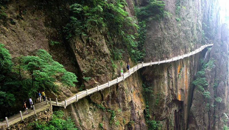
Bridge of the Immortals. 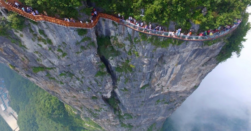
Bridge of the Immortals. -
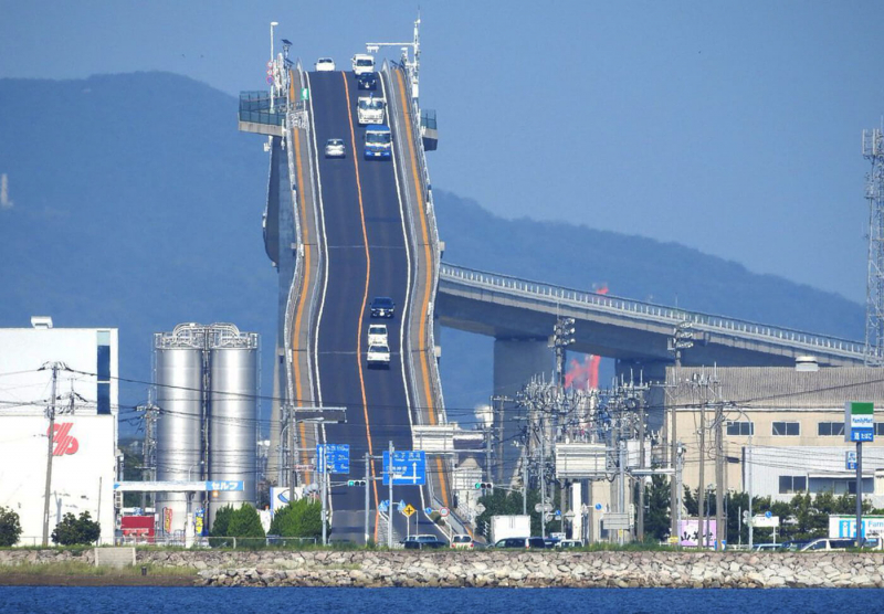
The Eshima Ohashi Bridge is a rigid-frame bridge in Japan that connects Matsue, Shimane Prefecture, and Sakaiminato, Tottori Prefecture over Nakaumi lake. It was built from 1997 to 2004, and it is the largest rigid-frame bridge in Japan and the third-largest in the world. Images of the bridge have been widely circulated on the internet, owing to its seemingly steep nature when photographed from a distance with a telephoto lens, but in actuality, it has a less pronounced, 6.1% gradient in the side of Shimane and a 5.1% gradient in the side of Tottori.
Eshima Ohashi Bridge replaced the previous drawbridge since traffic was obstructed often by ships for about 7 to 8 minutes, only large vehicles under 14 tons were allowed and only 4000 vehicles could cross it per day. This will feel nothing like a car journey because the Eshima Ohashi bridge is like a giant roller coaster waiting for you to cruise over it, to cross over to the other side of the Japanese coast.
Eshima Ohashi bridge 
Eshima Ohashi bridge -
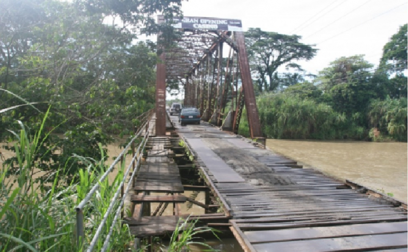
Quepos Bridge known as ‘The Bridge of Death’ and ‘Oh My God bridge’, this extremely narrow bridge is located on the road from Jaco to Quepos on Costa Rica’s central Pacific coast. It’s one of the most spectacular bridges in the world.
Cars can travel only in one direction. It barely looks like it could hold a bicycle, let alone a 30 tons lorry. But trucks cross this deathtrap regularly. The bridge built with wood planks looks like it could crumble at any moment, but large trucks drive over it and people survive. The loose slats of the roadway clank loudly while the bridge shakes under the weight of all the vehicles. Quepos Bridge was built by the “Bananera Company” in the years 1930-40, and it was built for the train that move the bananas to the port of Quepos.
The Quepos Bridge in Costa Rica was a former railroad bridge. It became an important link in the Parrita area. It was scary, but not dangerous unless you expected the bridge to collapse while you were on it. However, in 2010, the bridge was replaced by a modern concrete span. The span itself is not that wide, perhaps a few hundred feet at most, but it does go over a fast-moving river that often floods. Before the old bridge could be demolished, the area suffered a flood around the end of 2010 that results in the old bridge collapse.
Quepos Bridge 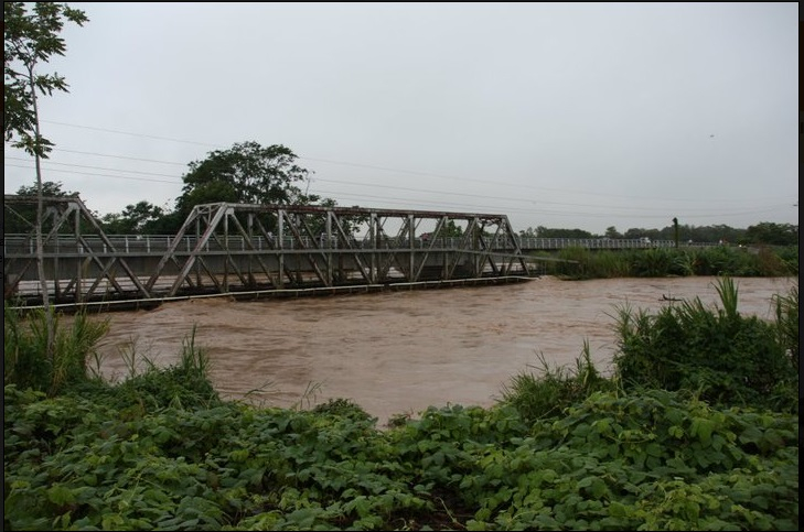
Quepos Bridge -
The Sidu River Bridge is a 1,222 m-long suspension bridge crossing the valley of the Sidu River near Yesanguan in Badong County of China. The bridge was designed by Second Highway Consultants Company, Limited. and built for 720 million yuan (approximately US$100 million). It opened to traffic on November 15, 2009.
The first part of the suspension cable installed, a rope known as the pilot cable was the first-ever to be placed using a rocket. Conditions at the Sidu River Bridge's location would not allow the use of boats or helicopters, which have previously been used to string the first cable. The rockets carried the pilot cables across on October 6, 2006, and resulted in time and cost savings.
Sidu River Bridge spans just over 5,000 feet across the river valley and was so far across that the builders had to use a rocket to string the first pilot line across the gap. The hefty length is supported by two massive, H-shaped towers, one at either end of the road. The Warren-type trusses were constructed in 71 sections with the largest section weighing 91.6 metric tons. The trusses are 6.5 m tall and 26 meters wide. The suspension lines dip in the middle and rise back up again, looking more than a little flimsy for such a massive span.
This is not to say that the Sidu River Bridge is not safe, as the huge amounts of steel and concrete that make up the bridge should be more than adequate to hold any amount of vehicles that might want to make the trip across.
Sidu River Bridge 
Sidu River Bridge -
The Bob Graham Sunshine Skyway Bridge often referred to as the Sunshine Skyway Bridge or simply the Skyway is a cable-stayed bridge spanning the Lower Tampa Bay connecting St. Petersburg, Florida to Terra Ceia. The current Sunshine Skyway opened in 1987 and is the second bridge of that name on the site. It was designed by the Figg & Muller Engineering Group and built by the American Bridge Company and is considered a symbol of Florida.
The original Sunshine Skyway Bridge opened in 1954 and was the site of two major maritime disasters within a few months in 1980. In January 1980, the United States Coast Guard Cutter Blackthorn collided with the tanker Capricorn near the bridge, resulting in the sinking of the cutter and the loss of 23 crew members. In May 1980, the freighter MV Summit Venture collided with bridge support during a sudden squall, resulting in the structural collapse of the southbound span and the deaths of 35 people when vehicles plunged into Tampa Bay. Within a few years, the damaged span was demolished, the surviving span was partially demolished and converted into a long fishing pier, and the current bridge was built.
On top of this, 207 people have committed suicide by jumping off the center span into the Tampa Bay waters since 1987 when the new bridge was reconstructed. Before that, another 51 people have jumped to their deaths before the older bridge collapsed. There are now 6 suicide hotlines placed along the Sunshine Skyway Bridge as a safety precaution and a constant reminder of its past.
During periods of severe thunderstorms, high winds, and hurricanes, Sunshine Skyway Bridge is often shut down due to high wind advisories. Avoid on a very windy or foggy day or storm as it generally is closed at that time. The grade is steep and you feel like you are on an endless ramp and will drop from a dizzying height after you reach the apex. The parallel lines of slanted bright yellow cables going by add to disorienting vertigo.
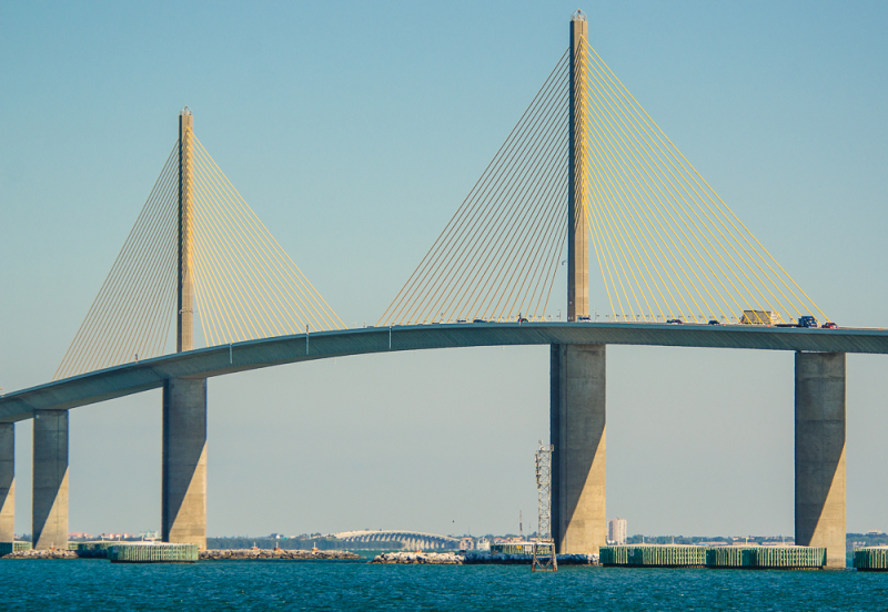
Sunshine Skyway Bridge 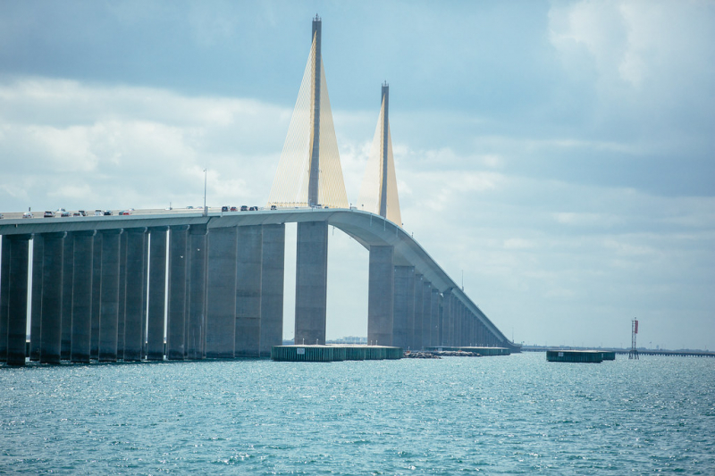
Sunshine Skyway Bridge -
The Titlis Cliff Walk is a pedestrian bridge along the cliff of Mount Titlis in the Swiss Alps. Built at around 3,000 m above sea level, it is believed to be the highest-elevation suspension bridge in Europe. It broke the record held by Salbit Bridge, also located in Switzerland. The bridge spans a distance of around 100 meters (320ft) but is just 1 meter (3ft) wide.
Constructed over five months, the Titlis Bridge was built when weather conditions permitted. It was designed to withstand winds that reach over 190 km/h (120 mph) as well as significant snowfall, with a spokesman for Titlis Engelberg ski resort explaining that it can cope with around 450 tonnes (500 short tons) of snow. Much of the material used in construction was transported on cable cars, with larger sections being delivered by helicopter.
At a cost of around £1 million, it is hoped that the Titlis Bridge will become a significant tourist attraction, particularly during the warmer months. In the first two weeks of it being opened, around 500 visitors crossed the bridge. Media reports called it the world's scariest bridge and Switzerland Tourism called it is a high-adrenaline kind of new adventure. The ski resort spokesman claims that the bridge is 100 percent safe and explains that it is impossible to fall from the bridge.
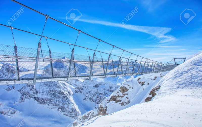
Mount Titlis Bridge 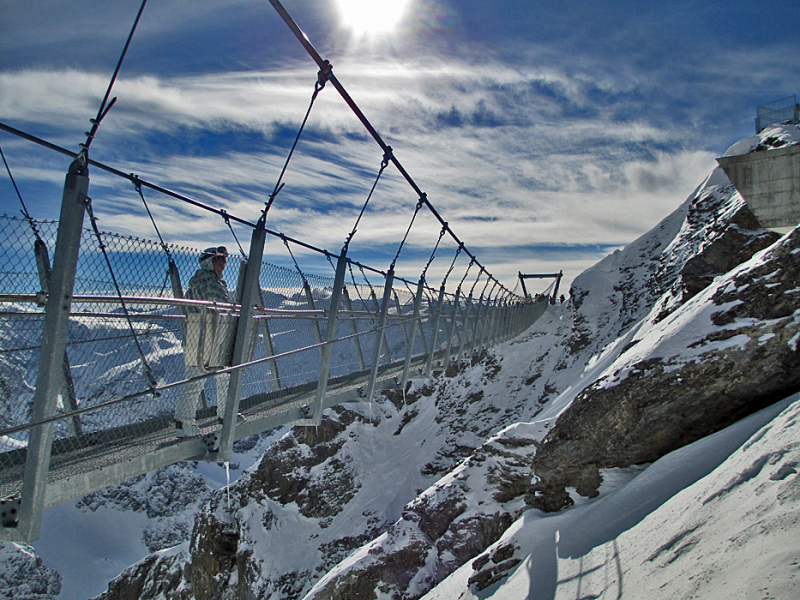
Mount Titlis Bridge -
Deception Pass Bridge is the common name for two, two-lane bridges connecting Whidbey Island in Island County, to Fidalgo Island in Skagit County, in the U.S. state of Washington. It was a Washington State Highways project and included project elements built by young workers from the Civilian Conservation Corps. Completion of the bridge was a factor in the decision to build Naval Air Station Whidbey Island and helped Oak Harbor flourish.
The bridge is one of the scenic wonders of the Pacific Northwest, are has two spans, one over Canoe Pass to the north, and another over Deception Pass to the south. Construction began in August 1934, and the completed bridge was dedicated at noon on July 31, 1935. The Wallace Bridge and Structural Co. of Seattle provided 460 tons of steel for the 156 meters Canoe Pass arch, and 1130 tons for the 297 meters Deception Pass span.
The road over the Deception Pass Bridge is Washington State Route 20. If the drive over this foggy strait in Puget Sound is not particularly scary to you, try walking over the narrow pedestrian lane at the edge of the bridge. That's where you will find especially hair-raising views of the rushing water directly below. Roughly 15,000 cars cross the bridge each day.
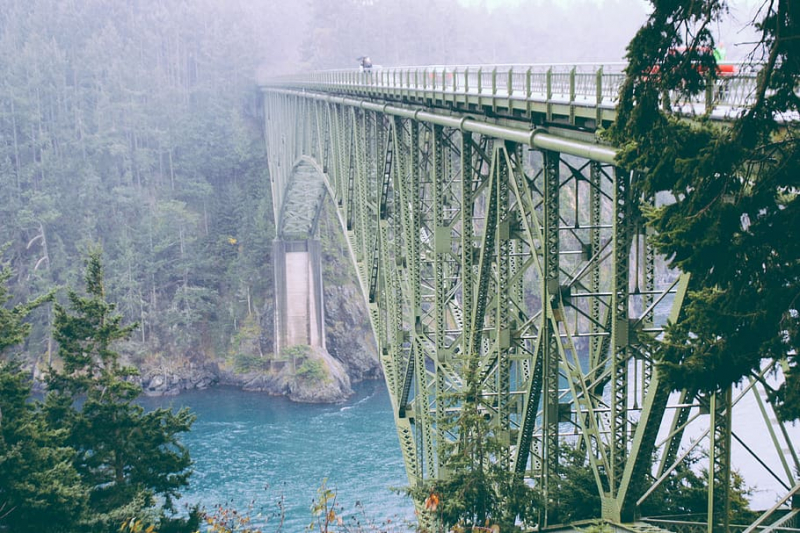
Deception Pass Bridge 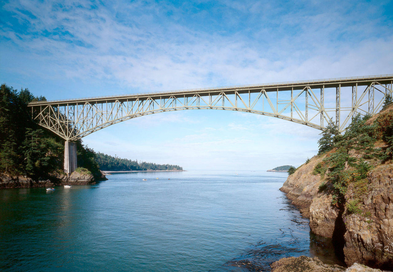
Deception Pass Bridge -
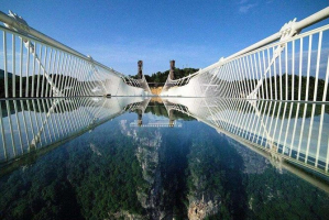
Langkawi Sky Bridge is a 125-meter curved pedestrian cable-stayed bridge in Malaysia, completed in 2005. The bridge deck is 660 meters above sea level at the peak of Gunung Mat Cincang on Pulau Langkawi, the main island of the Langkawi archipelago in Kedah.
The bridge is 125 meters long, and 1.8 meters wide, with two steel railings as well as steel wire mesh on either side. It is designed as a curved walkway to maximize the viewing experience, providing a shifting perspective as a visitor walks along the Langkawi Sky Bridge. The walkway, formed of steel and concrete panels set on top of an inverted triangular truss, connects two hilltops at Gunung Mat Chinchang.
The bridge is suspended by 8 cables from an 81.5m high single pylon and hangs at about 100m above the ground. The pylon is anchored onto a concreted pad set at an elevation of 604.5 meters, and its tip reached 686m above sea level. It is inclined at angles of 78° and 2° in two directions and is supported by two cables. The Langkawi Sky Bridge is designed to carry up to 250 people. It looks both futuristic and almost frighteningly precarious. And as it turns out, these fears might be justified.
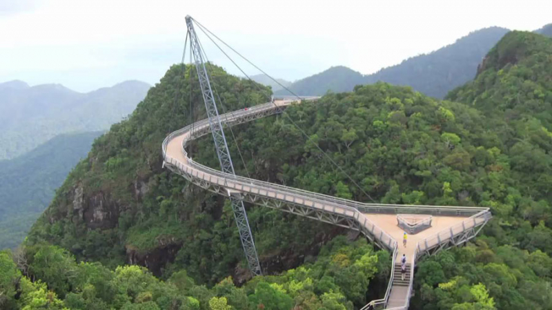
Langkawi Sky Bridge 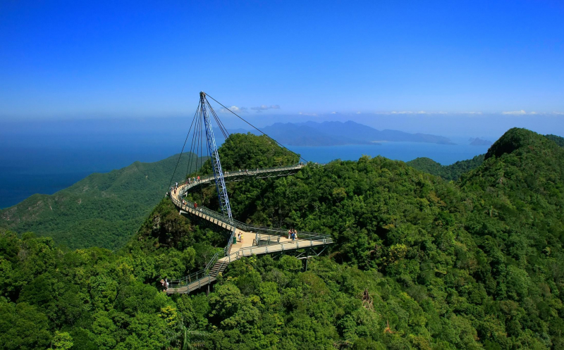
Langkawi Sky Bridge