Top 5 Most Beautiful Historical Sites in Zimbabwe

Zimbabwe's culture is not only diverse but also rich and deeply rooted, but also there are historical sites all around Zimbabwe that explain the country's way ... read more...of life and past history in detail. Today, let's follow Toplist to discover the most beautiful historical sites in Zimbabwe.
-
The stone ruins of an ancient city near Masvingo, Zimbabwe are known as Great Zimbabwe. People first settled in Great Zimbabwe approximately 1100 C.E., but they left in the 15th century. The capital of the Kingdom of Zimbabwe, a Shona (Bantu) commercial kingdom, was the city. In Shona, Zimbabwe means "stone dwellings."
Great Zimbabwe was a part of a vast and prosperous international commerce network. In the remains, archaeologists discovered pottery from China and Persia, as well as Arab coinage. The Zimbabwe Empire's elite dominated trade throughout the east African coast. However, by the 15th century, the city had largely been abandoned as the Shona people had relocated elsewhere. The exact reasons for the abandonment are unknown, but it is likely that exhaustion of resources and overpopulation were contributing factors.There are various portions to the archaeological site in Great Zimbabwe. The Hill Complex is the initial phase, which consists of a complex of structure remains perched atop the site's sharpest hill. This is widely assumed to have been the site's religious heart. The Hill Complex is the most ancient component of Great Zimbabwe, with architectural evidence dating back to roughly 900 C.E.
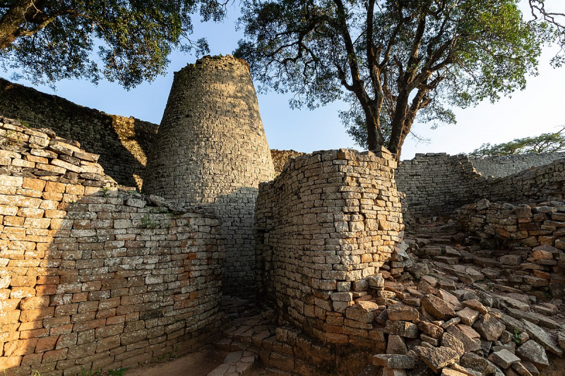
The ruins of the Great Enclosure, the second part, are undoubtedly the most interesting. The Great Enclosure is a 14th-century walled, circular region beneath the Hill Complex. The enclosure's walls reach a height of nearly 9.7 meters (32 feet) in certain parts, and its circle is 250 meters (820 feet). The walls were constructed without the use of mortar, relying instead on skillfully shaped boulders to maintain the wall's shape. A second set of walls surrounds the enclosure, following the same curve as the exterior walls and culminating in a stone tower that stands 10 meters (33 ft) tall. While archeologists are unsure of the enclosure's purpose, archeologists believe it may have served as a royal dwelling or a symbolic grain storage facility. It is one of the largest sub-Saharan African buildings still standing.
The Valley Ruins are the third portion. Near the Great Enclosure are the Valley Ruins, which consist of many mud-brick (daga) homes. Great Zimbabwe had a big population, estimated to be between 10,000 and 20,000 individuals, based on the distribution and quantity of homes.In the ruins, archaeologists discovered some soapstone bird sculptures. These birds are believed to have served a religious purpose and were possibly mounted on pedestals. These birds are national emblems of Zimbabwe and appear on the modern Zimbabwean flag.
In 1986, the ruins of Great Zimbabwe were declared as a UNESCO World Heritage Site by the United Nations Educational, Scientific, and Cultural Organization (UNESCO). It is also one of the most beautiful historical sites in Zimbabwe. The site has only been the subject of a few archaeological explorations.Location: Zimbabwe
Photo; wikipedia 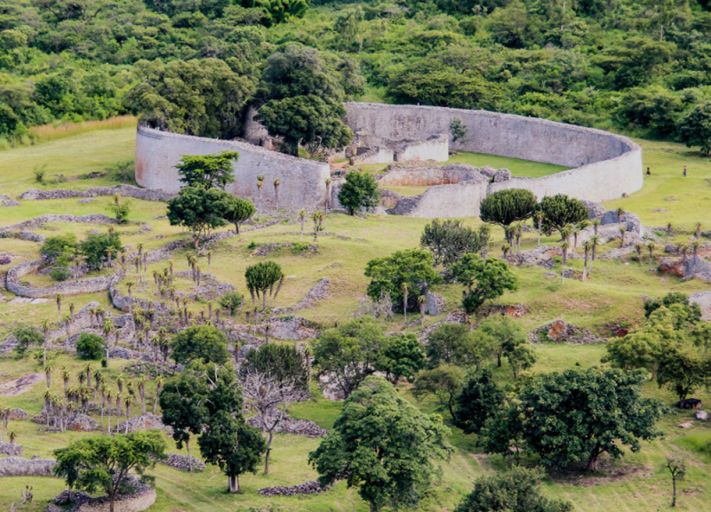
Photo: zimlegends -
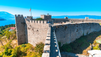
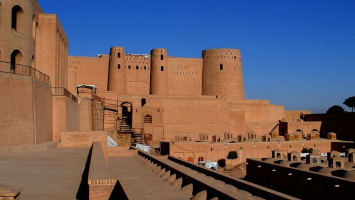
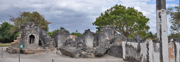
Khami (also spelled Khame, Kame, or Kami) is a destroyed city in Zimbabwe located 22 kilometers west of Bulawayo. It was previously the capital of the Torwa dynasty's Kingdom of Butwa. It is now a national monument, and in 1986, it was designated as a UNESCO World Heritage Site.
Khami was the Torwa dynasty's capital for roughly 200 years, beginning in 1450, and thought to have been founded around the time the state of Great Zimbabwe vanished. Changamire Dombo led an army of Rozvi rebels from the Mwenemutapa ("Monomotapa") State to take it after that (the traditional date is 1683). The location was not occupied after the Rozvi took possession, according to excavations. Danamombe (Dhlo-Dhlo), another Khami phase site, became the Rozvi's new capital. Nguni-speaking Ndebele warriors drove them out of Khami and many of the other settlements they had established in the 1830s.
The royal family occupied seven built-up areas on the site of Khami, while the commoners occupied open spaces in the valley. The structure consists of dry stone walls around circular, occasionally terraced, artificial platforms. The precipice platform's wonderfully ornamented 6m-high by 68m-long retaining wall has a checkerboard motif running the length of it. The platforms, which rose 2–7 meters above ground level, housed dhaka (clay) cottages and courtyards for persons of lower social position. Below the Hill Complex, the ruins of livestock kraals and regular people's homes can be observed. A royal enclosure or Hill Complex, which had to be built on higher ground than other structures, stone walls and hut platforms, and a Christian cross thought to have been put by a contemporary missionary are among the remnants. On the Khami River's eastern bank, there are other ruins. Cattle kraals and a checkered retaining wall are thought to have served as additional platforms. The walls of the western parts of the Hill Complex were completely painted in checker, herringbone, cord, and variegated stone blocks, according to recent excavations (2000–2006).
The Zimbabwean National Museums and Monuments initiated a restoration and recording initiative in the early 2000s with the goal of preserving and restoring the stone walls. To date, the notable achievements are the stabilization and restoration of terrace walls on the Main, Cross and North platforms.Location: Matabeleland North Province, Zimbabwe
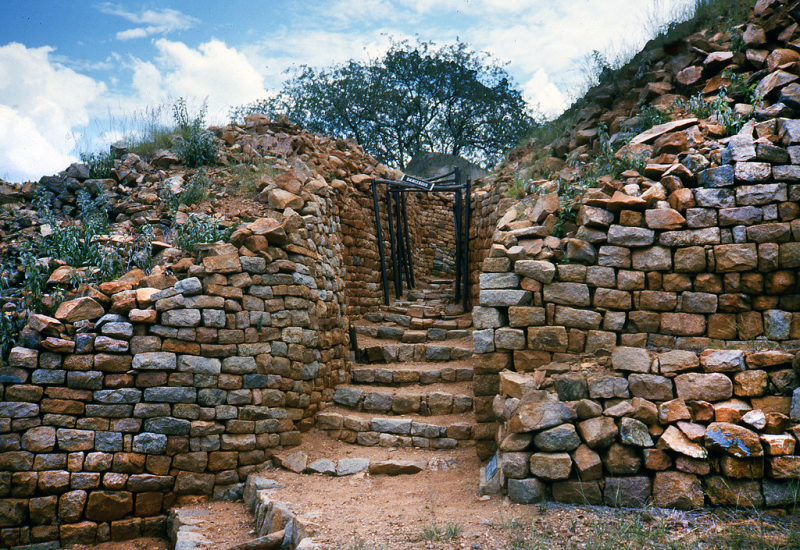
Photo: flickr 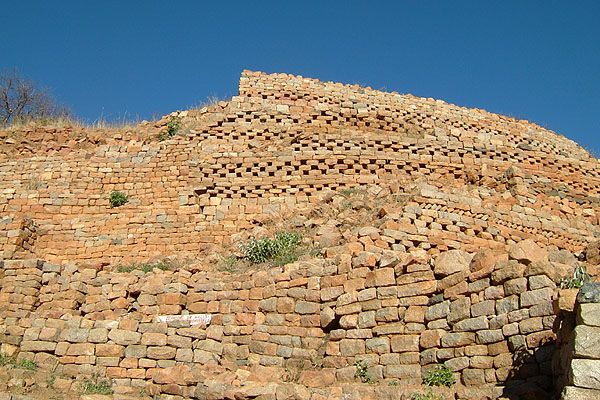
Photo: pinterest -
The region has a diverse range of rock features that rise above the granite shield that covers much of Zimbabwe. The enormous rocks provide plentiful natural shelters and have been associated with human settlement from the early Stone Age through early historical times, and on a sporadic basis since then. They have a fantastic collection of rock paintings as well. The Matobo Hills remain a powerful focal point for the local population, which continues to worship at shrines and sacred sites tied to traditional, social, and economic activities. And with the sight stunning, this hill is considered one of the most beautiful historical sites in Zmbabwe.
The Matobo Hills, 35 kilometers south of Bulawayo, are a smattering of unusual granite landforms that rise up to form a sea of hills, densely packed into a comparatively small space. Their shapes are the product of the granite rocks' varying composition and alignment, which responded differently to millions of years of weathering. In both natural and cultural terms, these magnificent granite rock formations have had a tremendous influence on the entire area.
For millennia, people have interacted with and been inspired by the stunning natural rock formations of the Matobo Hills. This interaction has resulted in one of Southern Africa's most impressive rock art collections, as well as strong religious beliefs that continue to play an important role in contemporary local society. It also demonstrates an almost continuous relationship between man and his environment over the past 100,000 years.
The Matobo Hills are home to one of the most extensive collections of rock art in Southern Africa, dating back at least 13,000 years. The paintings also show how artistic techniques and social religious views have changed over time. The entire bear bears witness to a rich cultural past that has since vanished. The abundance of evidence from archaeology and rock paintings at Matobo indicates that the Matobo Hills have been inhabited for at least 500,000 years. Furthermore, this data paints a complete picture of foraging cultures in the Stone Age, as well as how agricultural societies eventually displaced them in the Iron Age.
The Mwari religion, which is still practiced in the area and may originate from the Iron Age, is Southern Africa's most potent oracular tradition. The Matobo cliffs are thought to be the home of gods and ancestral spirits. Within the hills, there are sacred sites where one can make contact with the spiritual world. The shrines' living traditions constitute one of Southern Africa's most strong intangible traditions, and one that could be said to have universal importance. This is a collective rather than an individual response to a landscape. Matobo's natural attributes, such as the strength of the rocks and the produce of the surrounding natural environment, have deep cultural connections.
Location: Matobo (district), Zimbabwe
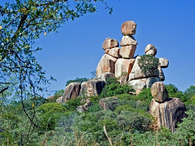
Photo: victoriafalls-guide 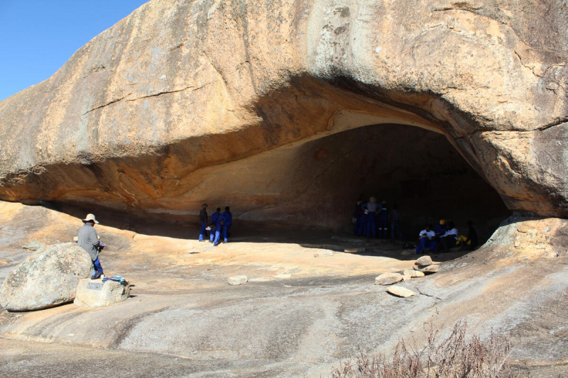
Photo: wmf.org -
The origins of the Tonga people can be traced back to Central Africa. Around the year 300, they came in Zimbabwe. Their predecessors preferred the riverine areas of Zimbabwe and Zambia near the Zambezi, Kana, Mzola, and Tshongokwe Rivers. They produced their crops in the fertile soils near the water's edge, augmenting their food supply in part by gathering wild plants, hunting the many wild animals, and, most significantly, fishing.
When the Kariba Dam was erected and filled in the late 1950s, the Tonga people were relocated from the Zambezi River's beaches. The Tonga people's socioeconomic and cultural milieu were severely disrupted as a result of their forced resettlement. This, combined with the various misconceptions held by outsiders about the Tonga people, prompted the Museum service to help promote their culture.
BaTonga Community Museum, which opened in September 2004 in Binga on the shores of Lake Kariba, aims to promote and empower local people as well as Tonga culture.
It highlights the Tonga people's customs, science, beliefs, and inventiveness in surviving in what many of us would consider a harsh, hostile environment. The rich history of Tonga is preserved here.Location: North Western Zimbabwe
Photo: naturalhistorymuseumzimbabwe 
Photo: zimbabwetourism -
The Chimanimani Mountains are a mountain range that runs along the Zimbabwe-Mozambique border. The mountains are located in the southern part of the Eastern Highlands, also known as the Manica Highlands, a belt of highlands that runs between the Zambezi and Save rivers and runs north and south along the international border.
Monte Binga (2,436 m), Mozambique's highest summit and Zimbabwe's second highest, is part of the Chimanimani Mountains. Forests, savannas, montane grasslands, and heath regions abound in the mountains. Parts of the range are protected by Zimbabwe's Chimanimani National Park and Mozambique's Chimanimani National Reserve. Chimanmani Transfrontier Conservation Area is made up of these two parks and a broader buffer zone.The Chimanimani Mountains are a historic range of mountains with massive volcanic rock formations. The mountain ranges are beautiful, featuring a series of stunning peaks. Mountains have an important role in Zimbabwean culture. The Chimanimani Mountains are home to the majority of the folklore centers, owing to the fact that the ranges' caves were used as a corridor during Zimbabwe's liberation fight. Rock climbing, hiking, camping, and birding are all popular activities in the highlands.
Location: on the border of Zimbabwe and Mozambique
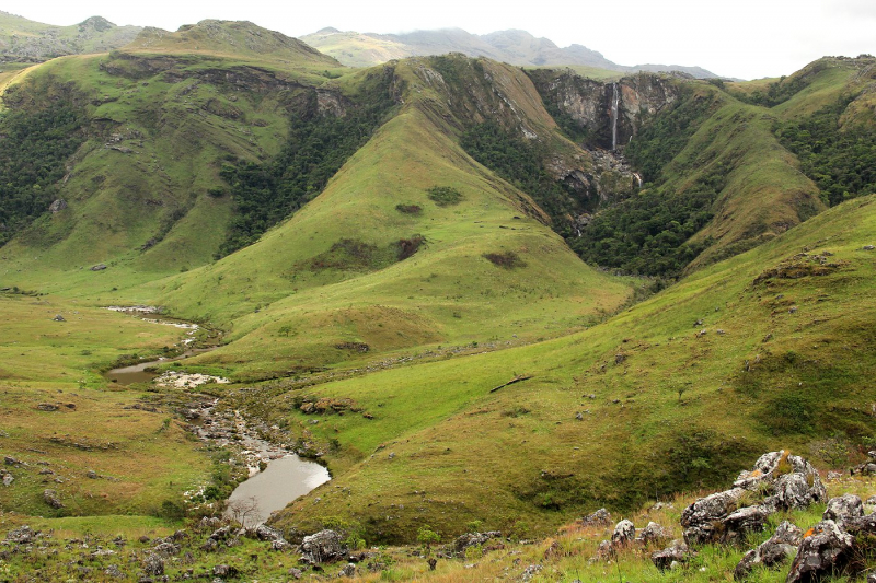
Photo: wikipedia 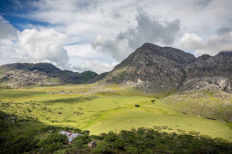
Photo: westernking