Top 5 Best Lakes to Visit in Chile

Chile is located in South America along a long, but narrow, swath of land bounded to the east by the Andes and to the west by the Pacific Ocean. Chile has some ... read more...of South America's most breathtaking and diverse scenery, including steep mountains and volcanoes, enormous deserts, sizable glacial lakes, and spectacular coastlines, despite its relative narrowness. The best lakes to visit in Chile are listed below.
-
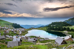
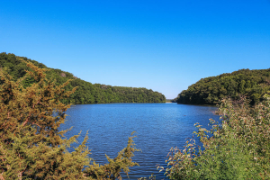
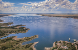
General Carrera Lake is one of Patagonia's most beautiful bodies of water. General Carrera Lake is the Chilean name for the lake, which spans both Chile and Argentina. On the Argentine side, it is known as Lake Buenos Aires. However, both names are widely used and internationally recognized, so take your pick.
General Carrera Lake is a fairly large body of water. It has a total surface area of 1,850 square kilometers, 970 of which are on the Chilean side and the remaining 880 are on the Argentina side. In terms of size, it is Chile's largest lake and Argentina's fourth largest. The lake is 586 meters deep at its deepest point.
The lake is located in the least populous district of Chile, Aysén del General Carlos Ibáez del Campo, on the Chilean side. You shouldn't stress too much about remembering the difficult name: The Aysén Region is a common name for the area.
The lake is located in the Santa Cruz Province of Argentina. This is also Argentina's least populous region, which may come as no surprise. General Carrera Lake is another excellent incentive to visit the region, while Los Glaciares National Park is undoubtedly its most well-known attraction.If you're planning a trip to Patagonia, include General Carrera Lake on your itinerary. There is plenty to do at General Carrera Lake, so plan ahead of time what you want to do the most. General Carrera Lake is difficult to beat for sightseeing. This is without a doubt one of the most beautiful lakes in the world, surrounded by the Andes mountain range. The glacial origins of the lake are clearly visible, and this is a photographer's dreamscape. Fishing may not be the first thing that comes to mind, but it is a very popular pastime at General Carrera Lake. Sport fishermen from all over the world visit the pristine lake for its abundant supply of trout and salmon.
Visitors with a sense of adventure won't want to pass up the chance to kayak on the lake and its surroundings. Kayaking is a great way to explore the lake's network of tunnels, marble caves, and other wonders. You can go hiking at General Carrera Lake, which is a perennially well-liked pastime in Patagonia. Although the terrain can be challenging, the hills and mountains that surround the lake offer numerous breathtaking vantage points of the lake itself.
This is the (slightly) challenging part. To visit the lake from the Chilean side, you must first travel to Coyhaique, the nearest city. In this case, "close" means a four-hour drive, so plan accordingly. It is entirely up to you whether to rent a car or use a tour operator. In any case, give yourself plenty of time to get there, see what you want to do, and get back. Of course, you could always choose to camp overnight - but keep in mind that it can get quite cold there!
Location: General Carrera Province, Aysén del General Carlos Ibáñez del Campo Region, Chile, in Patagonia
Basin countries: Argentina, Chile
Surface area: 1,850 km2 (710 sq mi)
Max. depth: 586 m (1,923 ft)
Surface elevation: 217 m (712 ft)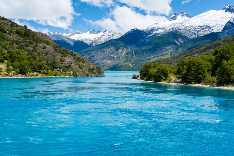
Patagonia and other adventure travel destinations - Australis 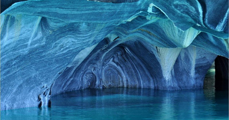
The Marble Cathedral of General Carrera Lake ~ Kuriositas -
After General Carrera, Lake Llanquihue is the largest lake in Chile. Its name, which means "submersion," (Mapuche language) has a surface area of 215,000 acres (86,000 ha).
The coastal cities of Puerto Varas, Frutillar, and Puerto Octay are all well-known for their stunning beaches, German-inspired architecture, and popular summertime activities. The beautiful pastries, which are based on German recipes for "kuchenes" (pies) and marmalades produced from various fruits, are another highlight of this area.
Llanquihue Lake's beauty and tranquillity will astound you, making it an ideal destination for long walks, breathing fresh air, and relaxing by its calm waters.
If you enjoy fishing, grab your gear and set sail on Llanquihue Lake. Experience the thrill of fishing with your rod in the midst of breathtaking scenery. If you are more active and enjoy sailing, go on a sailboat adventure to experience the area's characteristic wind. Visit Frutillar, Puerto Varas, Ensenada, and Puerto Fonk, which are all must-sees in this region of Chile.This location experiences oceanic and rainy weather with a light Mediterranean influence. It rains frequently and continuously, even in the summer. 11° C is the yearly average temperature. Because the weather can change quickly at any time of the year, you ought to wear rain-appropriate clothing. Rural stores are open all day, however they close between 13 and 15 in the afternoon. Since debit and credit cards are not accepted at kiosks and rural stores, you should bring local currency (Chilean pesos). Don't leave trash in parks or on the streets. All of us have a duty to protect our environment. Follow the guidelines to avoid paying fines.
Location: Southern Chile a territory of northern Patagonia in the Los Lagos Region
Basin countries: Chile
Surface area: 860 km2 (330 sq mi)
Max. depth: 317 m (1,040 ft)
Surface elevation: elevation70 m (230 ft)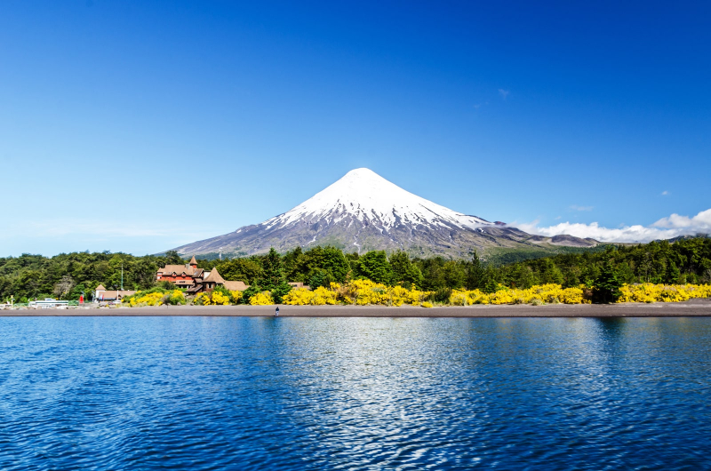
Llanquihue Lake - Chile Travel 
Llanquihue Lake - Chile Tours, Hoteles, Viajes y Turismo -
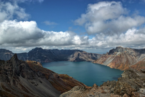
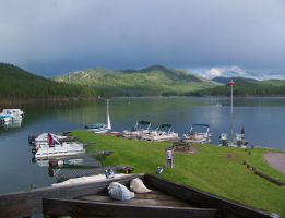
It takes some effort to get to O'Higgins Lake on the Chile/Argentina border. On the Argentina side, Lago O'Higgins is known as Lago San Martin. Lago O'Higgins is the deepest lake in the Americas, located in the Patagonian Aisen (or Aysen) Region. With a maximum depth of 2,743 feet, this is not only South America's deepest known lake, but also the world's deepest accessible glacial lake. While deeper, Lake Vostok in Antarctica is a sub-glacial lake with miles of ice covering its surface.
O'Higgins Lake is wedged between the Southern Ice Cap on the west and the Andes Mountains on the east, making it one of the most inhospitable places on earth. The eight arms of the lake spread into submerged valleys on both sides of the international boundary and are fed by the Mayer River and other glacier streams. The milky-blue water's color is a result of the finely crushed rock, or "rock flour," that is carried by melting glaciers in the streams that empty into the lake. Small boats are typically not an option in the main portions of the lake since high winds can produce hazardous waves. Locals are aware of the generally safe locations, however it is not advisable to participate in paddle sports alone. The lake is the source of the Rio Pascua, one of Chile's fastest-flowing rivers. The Rio Pascua tumbles wildly through rapids, gorges, and waterfalls after leaving the lake to reach the Pacific Ocean.
The enormous lake is located in one of South America's least populated areas, which is surrounded by steep slopes, glaciers, and distinctive flora and animals. The torrent duck, river otter, culpeo fox, huemul (an Andean deer whose population has fallen below 3,000), hawks, harriers, condors, and the Magellanic woodpecker all call the area around the lake and river home.
For the majority of the last century, the area was only accessible by foot, horseback, or small plane, with some visitors and supplies crossing the lake by ferry from Argentina. The Carretera Austral highway has only recently reached the town of Villa O'Higgins - the road's end. The gravel highway provided a route for long-distance cycle and hiking trekkers to enjoy the region, resulting in an increase in visitors who participate in strenuous sports. The road is mostly gravel and deserted, with the exception of the occasional cyclist camping alongside the path. On the area's rushing rivers, whitewater rafting is just emerging as a tourism industry. Visitors are advised to bring whatever they believe they will need because there are only a few items that may be obtained locally.
The flat enough for grazing land around O'Higgins Lake primarily used for sheep and cattle ranching. Glaciers cap the mountains above the rolling pasturelands, some with active volcanic vents. Villa O'Higgins has become a base camp for fly fishermen who come to catch rainbow and brown trout in the rivers and streams. Sport fishing trips can be arranged through Villa O'Higgins, and boat cruises on Lago O'Higgins take visitors to the base of the massive O'Higgins Glacier.
It is advised that visitors visiting the Lago O'Higgins region do not attempt to "fly by the seat of their trousers" when it comes to housing and transportation. It is better to book any excursion through a trustworthy travel agency or informed friend, especially the first time you go, because even boat plans can change on the fly. There are some private rentals available, but you must do your research because the lodgings might not be up to date and they might be challenging to reach. There is real estate in the region, but again, one should make sure that it is accessible and that certain essential services can be used. A trip to Lago O'Higgins is a once-in-a-lifetime experience for the adventurous traveler, with plenty of rugged travel and grand unspoiled vistas. Visit one of South America's last untouched wildernesses. Lago O'Higgins is not easy, but it is magnificent!
Location: O'Higgins Commune, Capitán Prat Province, Aysén del General Carlos Ibáñez del Campo Region, Chile
Basin countriesArgentina, Chile
Surface area: 1,013 km2 (391 sq mi)
Max. depth: 836 m (2,743 ft)
Shore length: 1525 km (326 mi)
Surface elevation: 250 m (820 ft)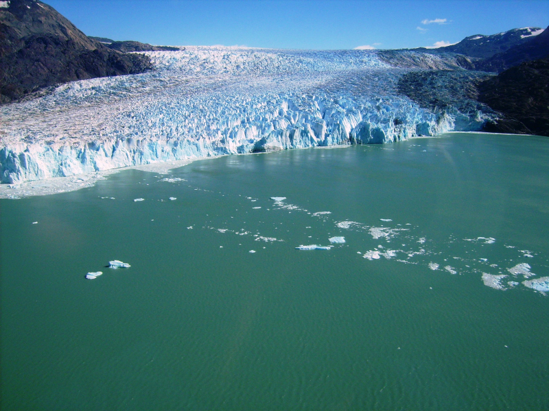
Wikipedia 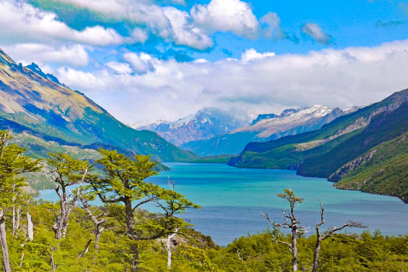
Stingy Nomads -
With a surface area of 102,500 acres (41,000 ha), Lake Ranco, which in Mapudungn means "crayfish waters," is surrounded by many islands, the majority of which are home to vacation homes and cabins. Ranco features a coastal road that follows the length of its beach, unlike other lakes in the region, allowing you to go around its whole perimeter. The lake offers a top-notch tourist infrastructure, with sport fishing as its main draw. Huapi Island, a Mapuche reserve, is also located in the middle of the lake, further enhancing the indigenous impact in the region.
This region of the country's cuisine is known for its good food, and it has a wide variety of traditional foods due to the influence of the Mapuche, as well as the Germans who arrived in the country. Typical dishes include the curanto, a soup made with meat, sausages, seafood, and potatoes, chapaleles, which are potatoes and flour cooked in the curanto broth, and milcao, which is also made from potatoes and is one of the most important foods in the area, along with meat and seafood. On the other hand, the German influence has allowed this area to be known for its cakes and pies made from local berries and fruits such as raspberries, blueberries, and myrtle.
The weather here is oceanic and rainy, with a touch of Mediterranean influence; there is abundant and consistent rainfall, even in summer. The average annual temperature is 11° C. We recommend that you dress in rain-appropriate clothing because the weather can change at any time of year. Rural stores are open all day, but close between 13.00 and 15.00. We recommend carrying local currency (Chilean pesos), as debit and credit cards are not accepted in kiosks and rural stores. Do not leave litter in parks or on the streets. It is everyone's responsibility to protect our environment. By following the rules, you can avoid fines.
Location: Ranco Province of Chile
Basin countries: Chile
Surface area: 410 km2 (160 sq mi)
Max. depth: 199 m (653 ft)
Surface elevation: 70 m (230 ft)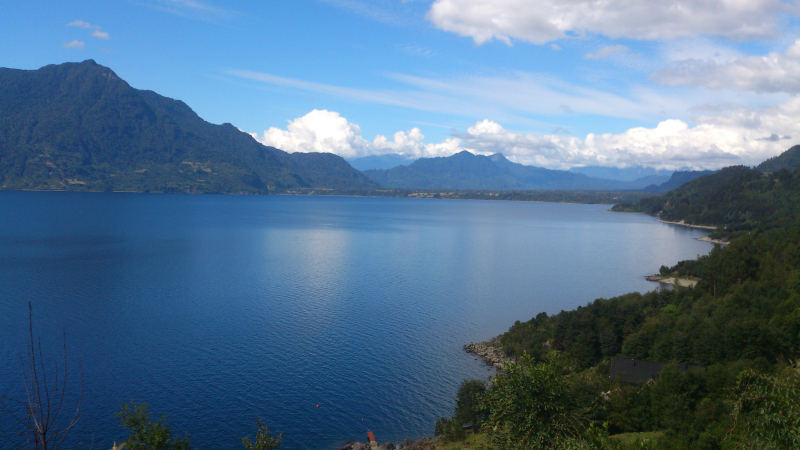
Ranco Lake - Wikipedia 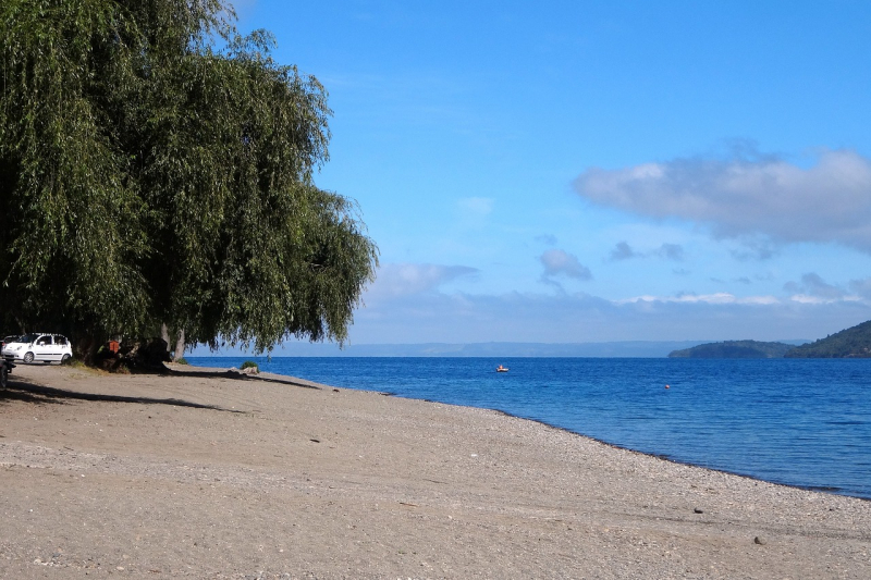
Pixabay -
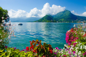
In Chile, Lake Villarrica shares its name with one of the country's most active volcanoes on its southern shore and a city on its western shore. All three combine to make the area known as Chile's Lakes District, a place of lakes and volcanoes, one of the top tourist destinations in Chile that offers year-round excitement and adventure tourism. Lake Villarrica is also known as "Mallolafquen," which means "cretaceous water" in pre-Hispanic Spanish.
Glaciers during the last ice age created the 42,749-acre Lake Villarrica. This sizable lake allows tourists to enjoy boating, kayaking, sailing, waterskiing, swimming, and beaches for sunbathing and relaxation during the summer when the water is in the 70s. Sport fishing is a lucrative industry, and there are many of guides that can take you to the ideal location for a memorable catch of trout, rainbow trout, and salmon.
Pucon, one of Chile's most popular tourist destinations, is situated on the eastern shore of Lake Villarrica. Vacation rentals in Pucon include spas, cabins, hostels, five-star hotels, condos, and privately owned summer homes. There are well-kept beaches on Lake Villarrica in this city for swimming, pedal boats, sunbathing, and relaxing. Casinos, restaurants, pastry shops, bars, and shopping venues line the streets. White water rafting on neighboring rivers is thrilling, as is horseback riding on the many trails surrounding the lake and area, which can also be used for hiking or biking.
A good real estate opportunity may be found along the 15-mile route that connects Pucon and Villarrica. This road borders Lake Villarrica and is lined with condominiums, chalets, and garden homes. Land ownership opportunities and property values are increasing in this area due to the tourist industry and people looking for vacation properties. Despite being more remote than Pucon, Villarrica gains from the area's fame. The primary industries in the region, in addition to tourism, are grain and dairy farming, as well as forestry in Huerquehue National Park. Budget-friendly vacation accommodations are available in this area, including bed & breakfasts, lodges, motels, and camping grounds. Fish, citrus, and regional veggies will tantalize your appetite in restaurants and neighborhood eateries.
The great Villarrica Volcano can be seen from anywhere in the Lake Villarrica area, no matter where you stay. During the warm summer months, guided tours will take you on a hike up the volcano, where you can peer into the bubbling lava inside the crater or admire the beauty of the area from a high altitude. During the winter, great skiing and snowboarding are available on the active volcano's slopes. For the brave, zip line rides through the forests are available. Villarrica National Park is home to all of this excitement, but you can also stroll the park's many trails to see the beauty of its exotic vegetation, rare creatures, or the naturally hot springs that were created when the volcano heated surrounding springs.
Imagine hiking up one of the world's most active volcanoes, then cooling off in beautiful Lake Villarrica. If you prefer colder temperatures, consider skiing down the side of the volcano and warming up in one of the hot springs. It is up to you to decide which season to visit, but Lake Villarrica will be a destination that you will remember for the rest of your life.
Location: Chile - Central Chile Region
Basin countries: Chile
Surface area: 173 km2 (67 sq mi)
Surface elevation: 230 m (750 ft)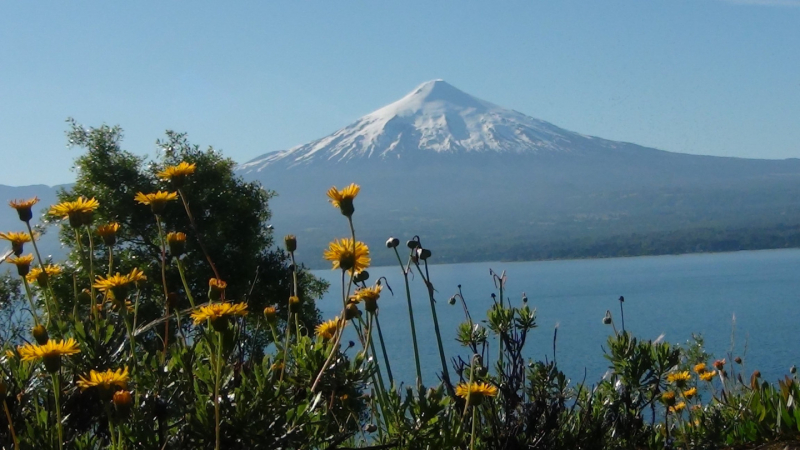
VisitChile 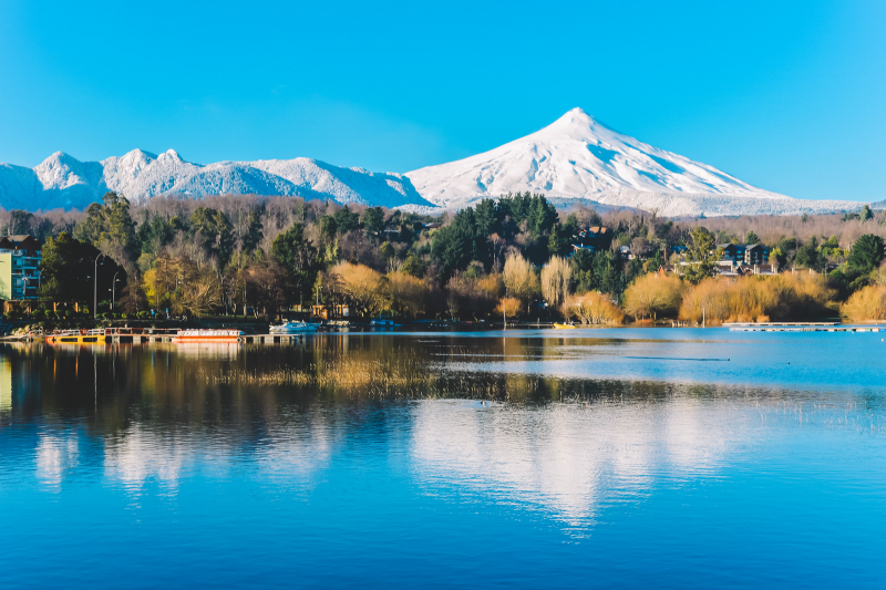
WOWabouts