Top 8 Best Lakes to Visit in Faroe Islands

The Faroe Islands are a group of 18 volcanic islands hidden away in the North Atlantic Ocean. Tourists visit this remote and little-known archipelago to take ... read more...in the breathtaking natural surroundings. Amazing lakes and lagoons are scattered throughout many islands in this unexplored region of the planet. Regardless of size, they all add up to incredible travel experiences. Here are the best lakes to visit in Faroe Islands.
-
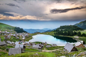
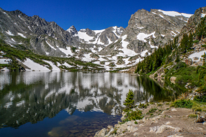
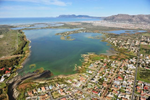
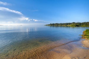
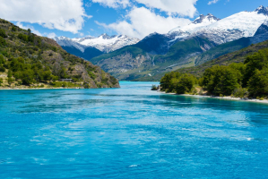
The Faroe Islands contain Lake Leitisvatn, also called Srvágsvatn. The lake is 3.6 square kilometers in size. This is the renowned lake that, when viewed from the Traelanpan cliff, will provide an optical illusion. The most well-known and biggest lake in the Faroe Islands is this one. This lake is a floating body of water that is 3.6 square kilometers in size and 6 kilometers long. The lake is situated on the Vágar islands, close to the airport, between the communities of Mivágur and Srvágur. Located in the lake, the statue of Nix is illuminated at night.
The local villagers frequently discuss the lake's name. While residents in the villages of Mivágur and Sandavágur to the east like Leitisvatn, those in Sørvágur to the west of the lake prefer Sørvágsvatn. Due to the optical illusion you will experience from the steep cliff Traelanípan, travelers choose to refer to it as "The Lake Above the Ocean." The waterfall Bøsdalafossur, which cascades from the lake into the North Atlantic Ocean, is reachable on foot from Traelanípan. If you enjoy fishing, this is the ideal location. Going on a kayaking tour of the largest lake in the Faroe Islands is an even more well-liked pastime. You must hike for an hour to reach these sights, the entire time walking alongside a lake. The trail will lead you southwest in the direction of the lake before gradually turning south and following the lakeshore from a few hundred meters above. The trail is not at all challenging to follow and is very simple.When you get to the cliffs, the trail ends and becomes open grass walking after about 1.5 kilometers. You can find some pretty amazing views by climbing to the top of the cliffs that stand between the lake and the ocean.
Location: Vágar island
Photo: Windows 10 Spotlight Images 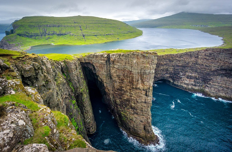
Photo: Lets Travel More -
Lake Fjallavatn is the next best lake to visit Toplist want to share. On the island of Vágar, Fjallavatn is situated in the mountains close to the communities of Sørvágur and Vatnsoyrar and close to the airport. With a surface area of 1.03 square kilometers, Fjallavatn is the second-largest lake in the Faroe Islands. People frequently go further to the shoreline of Lake Fjallavatn to get a spectacular panoramic view of Víkar. Orcas and seals can occasionally be seen in this bay. Sørvágsvatn is a lake that will nearly always be included on a visitor's itinerary while traveling to the Faroe Islands. This lake, which is surrounded by craggy rocks, has an unique optical illusion that makes it stand out and solidifies its status as one of the most well-liked tourist destinations in the Faroe Islands.
You must follow the path from the tiny settlement of Vatnsoyrar in order to get to the lake. In Vatnsoyrar, the trailhead is situated near where campers park. On your way to Fjallavatn, you will cross a river, so be sure to wear sturdy hiking shoes. Each way, the hike takes two to three hours. As you stroll through serene nature, you'll be rewarded with unaltered views. A breathtaking view of jagged peaks rising abruptly from the untamed ocean and a relentless stream of waves pounding on the hidden dark beach below is revealed at the far end of the lake as the landscapes open up. Seabirds soar overhead, and in the distance, a neat patchwork of well-kept farmlands can be seen. This tiny region marks the mysteriously deserted settlement of Vkar, which is indicated by a couple of decaying cottages below the cliffs. The hike is especially popular in the summer. This is the time when you can experience both sunrise and sunset within a short period of time.
Location: Vágar island
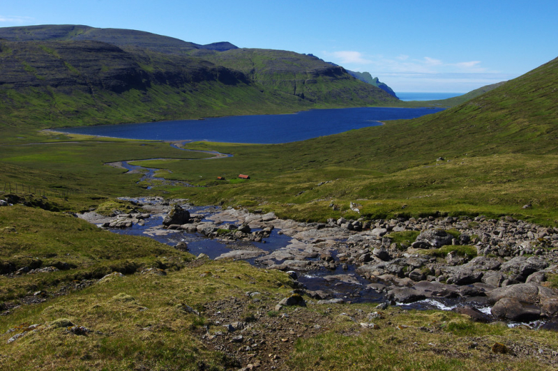
Photo: Flickr 
Photo: The Sandy Feet -
The largest lake on Sandoy island and the third largest lake overall in the Faroe Islands is Sandsvatn. Between the towns of Sandur and Skopun is the lake. It is 640 meters broad and 2 kilometers long. The lake is well-liked by kayakers and sports fishers and is tucked away in peaceful surroundings. Small valleys surround visitors, giving Sandoy an appearance that is softer and rounder than most of the other islands in the interior. You may appreciate the diverse bird life and lush vegetation surrounding the lake on Sandoy, the most fertile island in the Faroe Islands. A fantastic and enjoyable activity is kayaking on Lake Sandsvatn. You will be able to see firsthand the pristine natural splendors of this beloved lake on Sandoy thanks to this.
At the base by the riverbank right outside the village of Sandur, you can pick up a kayak. This expedition is ideal for paddlers of any skill level who want to experience something genuinely unique while visiting the Faroe Islands. Every kayak is a single-person vessel. You may paddle about the lake for hours while taking in the picturesque vista of the soggy river bank and low mountains that surround Lake Sandsvatn.
Location: Sandoy island
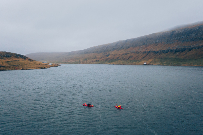
Photo: Guide To Faroe Islands 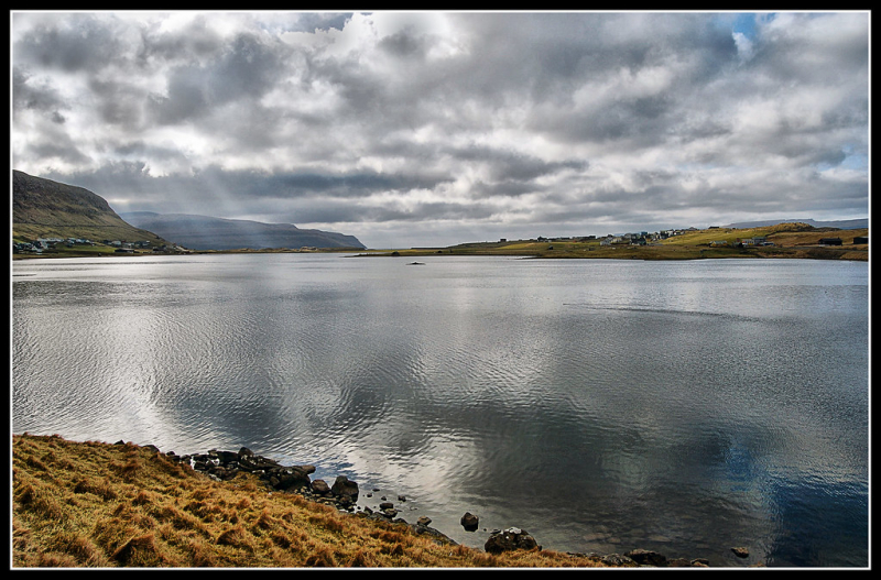
Photo: Flickr -
Take a stroll around the lovely Lake Toftavatn on the island of Eysturoy. With a surface area of 0,51 square kilometers, this lake is the fourth largest in the Faroe Islands as well as one of the best lakes to visit in Faroe Islands. There are about 3,5 kilometers to stroll around the lake. Around Lake Toftavtan, there is a lovely trail. Take in the beautiful birdlife, the diverse flora and fauna, and the statue of the shepherd and his dog. You may reach Svangaskarð, the Faroe Islands' first international football stadium, by ascending a hill on your route around Toftavatn. The view is excellent from the summit.
A short morning or afternoon hike would be ideal in the flat, heather-covered area surrounding Lake Toftavatn, which is located south of Runavk. It just takes around two hours to traverse the length of the lake. Additionally abundant in the region is the birdlife, which peaks in the warm months when migratory birds return to the Faroe Islands to breed. Binoculars should be brought by bird watchers. In the television show TROM, Lake Toftavatn is mentioned. When you watch the criminal drama, you'll see a little pink house beside a lake. This is Toftavatn Lake. The shack is effectively concealed by the surrounding landscape, and it is a different color than the one in the crime series.
Location: Eysturoy island
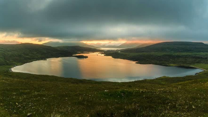
Photo: Guide To Faroe Islands 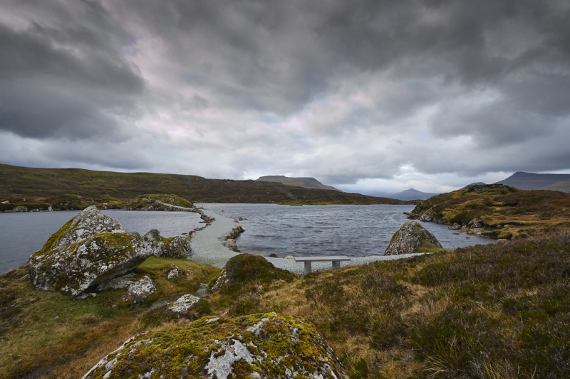
Photo: Visit Runavík -
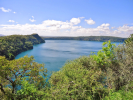
One of the best places for sport fishing is Leynavatn. You can catch trout and salmon here. When leaving the underwater tunnel connecting Vágar to Streymoy island, the lake is located right next to the road. The lake has a footprint of 0.18 square meters. You may locate a broad road just adjacent to Leynavatn where summertime local horse races take place. The horses running by the lake are quite intriguing to watch. Only a few steps from the lake, the renowned restaurant KOKS used to host international foodies in Frammi vi Gjónna. In the Faroe Islands, the Michelin-starred eatery shut its doors in 2021. Visit this location to take in the tranquil atmosphere.
A little valley, a gorge, and the region around Lake Leynavatn are among the highlights of a fascinating and stunning trek that visitors can enjoy. One can stroll along the river Lagá, which is both quite wide and narrow at different points near the village of Hósvk. Just outside the settlement gates, a confluence of many larger rivers empties into Lagá. This is a beautiful location to visit with its rivers and their tributaries. You arrive in the Smrdalur valley by ascending the Smrdalsá River. The only sounds at this point are a babbling creek and the song of the birds. It's as if you've entered another world, where the scars left by peat cutters take you back in time. Excellent views can be had of the Mjáuvøtn lakes, the valley of Kollafjørður, the Vestmannasund strait, and the island of Vágoy.
Location: Streymoy island
Photo: Guide To Faroe Islands 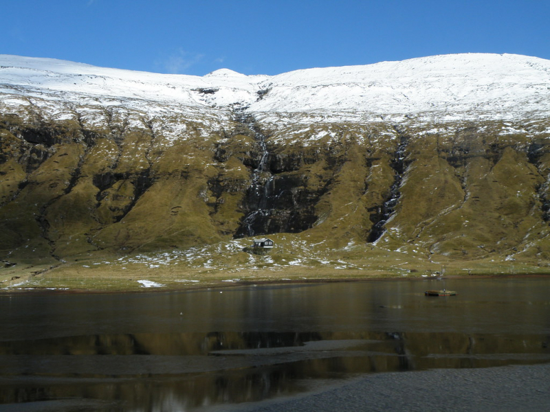
Photo: Flickr -
Talking about the best lakes to visit in Faroe Islands, lake Vatndalsvatn is not to be missed. The Faroe Islands include a variety of lake shapes. You may see a breathtaking heart-shaped nature sign in Lake Vatndalsvatn. It is perfect for a passionate mountain hike. The lake, which is situated above the community of Bøur, is the third-largest on the island of Vágar. The area around it is among the most stunning in the nation. Lake char, brown trout, sea trout, sea char, and the sporadic salmon make up the catch. A short distance away, the Hotel Flokalundur offers lodging options. Brianslaekur also has camping areas. The sagas mention the bay Vopnafiord, where one of the nation's discoverers, Raven-Floki, landed and gave the nation its current name.
You must trek up the mountain Eindalsfjall, following the river Breiðá, to get to the attraction. Although the ascent is hard, it is totally worthwhile. The hike to the lake lasts around an hour. You will enjoy a breathtaking panoramic view of the west coast of Vágar, including Tindhólmur islet and Mykines island, as you arrive at the lake. Vatnsdalsvatn appears to be totally heart-shaped on the map, but over time, the coast around it has taken on a somewhat different shape. Because of this, it's perfect for a romantic hike, and many couples have taken pictures with the heart-shaped lake as the backdrop. But don't forget to look around you, for from the same place you may capture the image of the heart-shaped lake and enjoy a stunning panoramic view.
Location: Vágar island
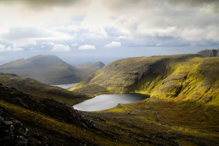
Photo: Guide To Faroe Islands 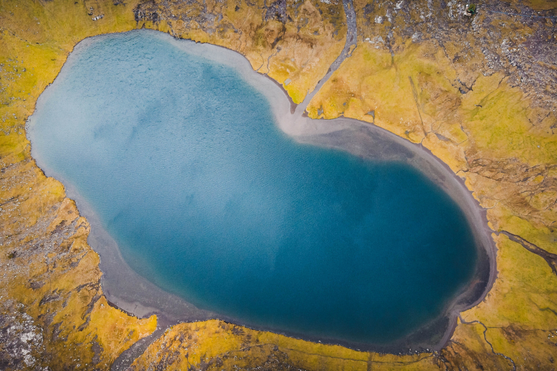
Photo: Roy Mosterd -
On the island of Suðuroy, Kirkjuvatn is situated north of the community of Fámjin. The lake is the largest lake on Suðuroy island and measures 0.2 km2. Although the ascent to Kirkjuvatn is difficult, the lake is visible after you have reached the summit. It draws both locals and visitors from far and wide because of its picturesque position. Another significant pastime that is well-liked by tourists is fishing. On the lakeshore, one can have a picnic or go exploring in the breathtaking countryside. Lake Kirkjuvatn is located in lovely settings above the Fámjin village. The Lake of the Church is what the name implies. Follow the trail that is visible behind the church in Fámjin to get to your destination. From the villages, it is simple to walk to the lake.
A little village, Fámjin. There is a calm and serene mood in the settlement. The church in Fámjin, which was constructed in 1876, is a historical landmark in the Faroe Islands, particularly because the church is home to the first-ever Faroese flag. Jens Olivur Lisberg from Fámjin and two other of his companions created it in 1919. The hike is undertaken by both locals and tourists, and is particularly well-liked in the summer. Summertime brings long days and late sunsets. At Lake Kirkjuvatn, you can take in both the lake and an unobstructed view of the ocean. The very reason people travel is served by this place.
Location: Suðuroy island
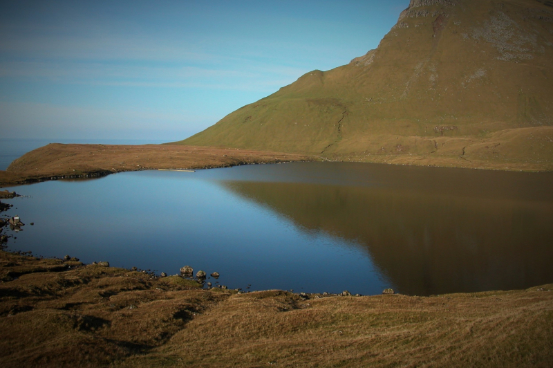
Photo: Wikipedia 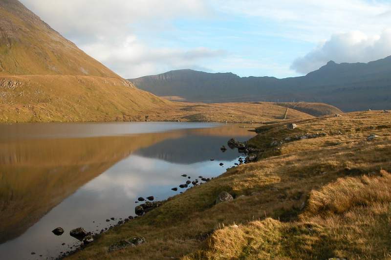
Photo: Flickr -
Experience the wonderful setting of the Pollurin Lagoon, one of the best lakes to visit in Faroe Islands. The lagoon is situated beneath the isolated community of Saksun. Actually, Lake Saksunarvatn is what you will first notice when you arrive at Saksun. You will reach the Pollurin lagoon as you travel further down the road. You must visit the famous turf-roofed church while in Saksun. Additionally, the little community has a museum. This remarkable place is all about getting away from it all and taking in the incredible scenery. The lagoon once formed a nice natural harbor, but sand from a storm obstructed it. Only small boats can get there during high tide. You can traverse the sand to the beachfront during low tide. Beautiful waterfalls cascade down the jagged mountain sides as you stroll along the sand.
Visitors can also enjoy the unique village with houses that resemble the "hobbit" village from "Lord of the Rings," but they are actually old homes with distinctive turf roofs.. Good grazing land was used to harvest sod or grass for roofing. The perfect material for the roof was a naturally occurring grass with extensive roots. The turf was divided into pieces and placed on birch bark after being transported up on the roof. Since the grass would shield the bark and serve as a drain, the initial layer of sod was typically laid with the grass down. To create a stable surface, the second layer's grass was oriented upward. The roots of the two layers would eventually converge to form a sturdy structure.
Location: Streymoy island
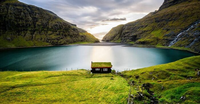
Photo: Guide To Faroe Islands 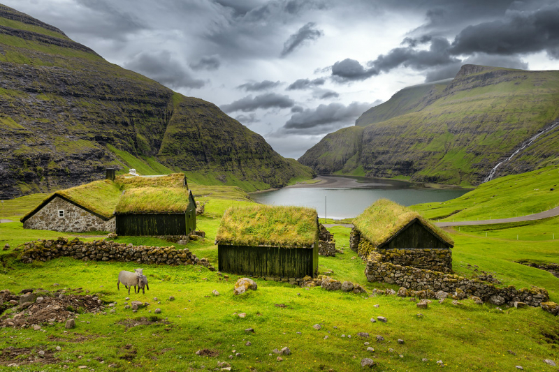
Photo: Flickr