Top 10 Google Earth Discoveries

Google Earth didn't instantly turn office globes into decorative items when it first appeared on the Web in 2005, but it did allow for easy global exploration ... read more...with just one click. There have been some extraordinary and incredible Google Earth discoveries, from simple browsing to accessing satellite images, so the product hasn't just been a neat toy. Numerous satellite image discoveries have included underwater landforms, pyramids, and fossilized bones. Here is the list of fascinating Google Earth discoveries.
-
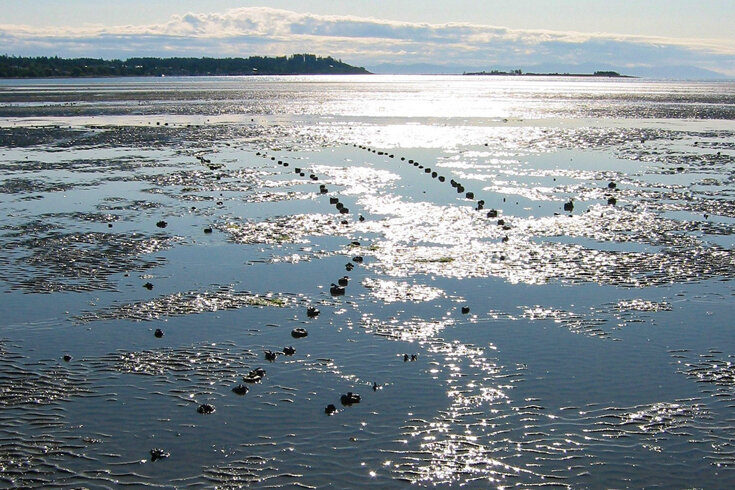
The S.S. Jassim shipwreck tops the list of Google Earth discoveries. In addition to accidents on land, there are also maritime mishaps that result in the sinking of ships. The largest shipwreck that can be found on Google is in North Sentinel Island, South Andaman, Andaman and Nicobar Islands, India. Bolivian cargo ship Jassim, measuring 265 feet, ran aground and sank on Wingate Reef in 2003. In 2003, the Bolivian ferry ran aground in shallow water off the coast of Sudan. The shipwreck wasn't actually located on Google Earth, but the image was, and is now the largest, most recognizable, and most looked-for shipwreck.
Researchers, explorers, and scientists have placed more emphasis on using the Google Earth feature to survey the world and make previously unnoticed and undocumented discoveries known as a result of all these incredible and amazing discoveries on Google Earth. As the platform develops, more and better satellite images will be found, elevating Google Earth to a new level.
Anyone can now access images that were previously only available to governments from the comfort of their own homes or anywhere else without going through NASA. The location is not really accessible to tourists because a dangerous tribe calls it home. The island, which is nearly the size of Manhattan, has never been in contact with the outside world, according to reports. Two fishermen were also killed by the tribe when they entered the area.
- Where: Andaman and Nicobar Islands, India
- Year of Discovery: N/A

wikimedia.org 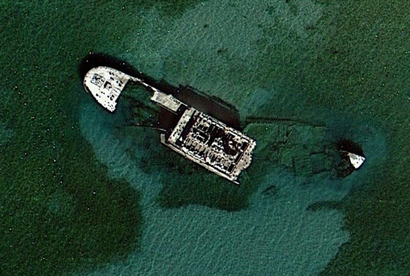
pinterest.com -
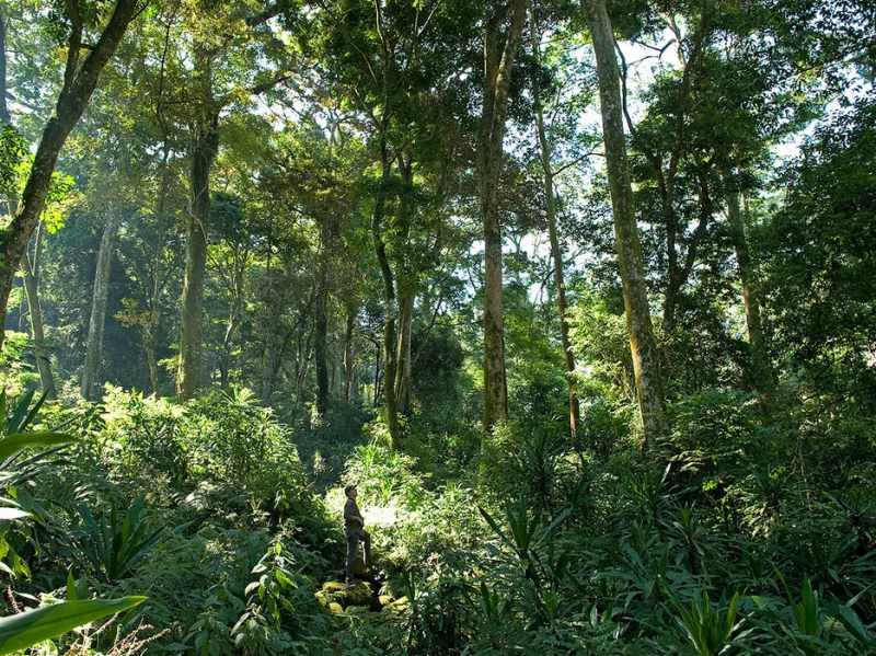
Google Earth was used by botanists at Kew to survey a few notable regions in Africa. On Mozambique's Mount Mabu, they found green patches that turned out to be the largest, unrecorded rainforest in southern Africa.
Explorers and scientists had not been able to survey the region in the past due to the Mozambique civil war and the challenging terrain. It is also thought that the species there may have developed independently, uninfluenced by other known creatures, over a long period of time. As soon as possible, scientists made travel plans and investigated the area.
The locals had always been aware of Mount Mabu, but scientists had never investigated it. In light of Mozambique's civil war, which ravaged much of the nation's natural environment and terrorized its citizens from 1977 to 1992, the discovery was also noteworthy. Seven new populations of globally endangered bird species, including the Thyolo alethe, whose other populations are all threatened by logging and deforestation, Swynnerton's robins, and Namuli apalis, are among the 126 species of birds that have been identified. These species include the Namuli apalis and the Swynnerton's robin.
- Where: Mount Mabu, Mozambique
- Year of Discovery: 2005
cntraveler.com 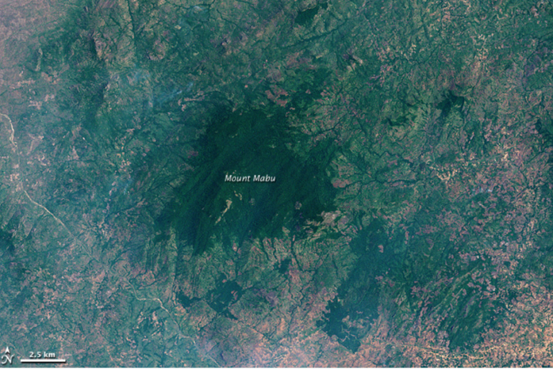
geoawesomeness.com -
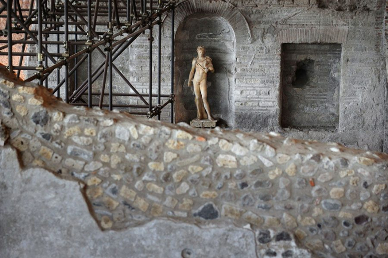
An Italian computer programmer discovered the ruins of an old villa using satellite images from Google Maps and Google Earth. Luca Mori noticed a prominent, oval, shaded form that was more than 500 meters long while looking at maps of the area surrounding his town of Sorbolo, which is close to Parma. Because former watercourses absorb different amounts of moisture from the air than their surroundings do, they can be seen as the meander of an ancient river.
He noticed some strange "rectangular shadows" in the area. He looked more closely at the image out of curiosity and came to the conclusion that the lines must be a structure that was buried and had human origins. He eventually traced out what appeared to be a villa's interior courtyards.
Mori contacted archaeologists, including those at the National Archaeological Museum of Parma, and writes about the discovery on his blog, Quell Della Bassa. They verified the discovery. Initially believed to be a Bronze Age village, it was discovered during an inspection of the site to be a Roman villa.
According to Manuela Catarsi Dall'Aglio, an archaeologist at the National Archaeological Museum of Parma, "Mori's research is interesting in its approach." According to him, the discovery might be related to a villa discovered at Cannetolo di Fontanellato during the building of a high-speed rail network and currently being excavated by the museum. He continues, "Only a scientific, archeological dig will tell.
- Where: Sorbolo, near Parma
- Year of Discovery: 2005
allthatsinteresting.com 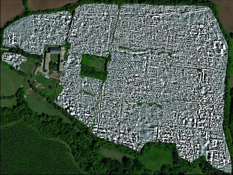
businessinsider.com -
Google Earth technology is being used by The HALO Trust to increase transparency in humanitarian landmine removal. The most affected areas are near the Thailand border where regular clashes occur and in Angola’s Cabinda province previously ravaged by civil war. Angelina Jolie, a steadfast supporter of HALO, has created tours of mine-affected areas that can be viewed in Google Earth software and take viewers to mine-affected areas in Cambodia and Angola.
Explore a Minefield demonstrates how mineclearance has enabled families to reclaim their homes, land to be used for agriculture, roads to be reopened, and kids to safely walk to school. In other words, mineclearance has enabled communities to flourish. Additionally, it displays to viewers any remaining minefields in villages that need to be cleared.
HALO uses Google Earth Pro in thirteen countries as part of a grant from Google Earth Outreach for minefield surveys, data validation, and the creation of maps for donors, governments, and other NGOs. HALO is able to provide time-lapse pictures that amply demonstrate how demining is assisting in the reconstruction of war-torn communities thanks to Google Earth's historical imagery. The Google Earth Outreach Developer Grant used to fund Explore a Minefield helped HALO achieve its goal of "getting mines out of the ground, now." This is definitely one of the most important Google Earth discoveries.
- Where: near Thailand
- Year of Discovery: N/A

phys.org 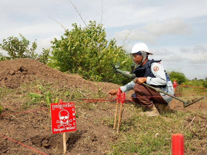
canberratimes.com -
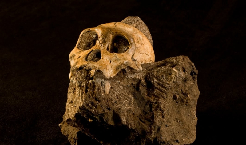
Scientists in South Africa have found two 1.9 million-year-old skeletons that may be an early ancestor of modern humans thanks to Google Earth. The fossils were discovered in the unexplored Malapa caves near Johannesburg in March 2008, according to paleoanthropologist Lee Berger and his nine-year-old son Matthew, but they only made the discovery public on Thursday.
Known as Australopithecus sediba after the Sesotho word for "well-spring," the 130-bone collection consists of two incomplete skeletons. The unexplored fossil site was discovered after a Google Earth and satellite image survey of the area, according to the researchers, who claim to be currently excavating at least two other skeletons of the same species there.
The bones, which depict a small-brained, bulky-appearing creature, allude to traits shared by modern Homo and earlier Australopithecine species. They were tall for their time (4 ft. 4 in.) but squat in shape, had the dainty teeth and protruding nose of a modern human but a tiny brain, and they walked upright but sought shelter in trees, according to the evidence.
They also had long arms with fairly contemporary hands and long legs with ape-like feet. The discovery might alter the course of human evolution as currently understood by scientists. The question of whether this species is a real ancestor or merely a related branch of the same family tree is debated by scientists.
- Where: Cradle of Humankind, Maropeng, South Africa
- Year of Discovery: 2008
africa.googleblog.com 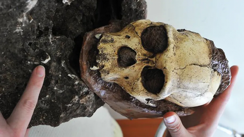
foxnews.com -
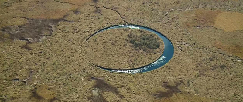
Known as "The Eye," this enigmatic floating island spins continuously in a slightly larger circular lake in a remote swamp in northeastern Argentina. It was found by a horror film director looking for locations for filming, and subsequent site visits have revealed methane gas under the water is likely aiding in its flotation. However, no one is certain how it came into being.
Sergio Neuspillerm, an Argentine film producer and director, found The Eye six months ago while looking for locations to shoot a movie about local paranormal events like ghost and alien sightings. Neuspillerm and his crew knew they had stumbled upon something truly special when they saw the unusually round island surrounded by an equally round body of water on Google Earth, so they abandoned their original film project and chose to concentrate on this mystery instead.
For the past ten years, The Eye has reportedly been visible on Google Maps at the coordinates 34°15'07.8'S 58°49'47.4′′W, but nobody ever paid it any attention before the Elojo project became well-known. Now, there are numerous theories about its existence circulating online. The locals think that the rotating island's circle-within-a-circle shape symbolizes the presence of God on Earth, while the majority link it to UFO activity and even go so far as to say that it hides an alien base.
- Where: Ojo de la Tierra, Paraná Delta, Argentina
- Year of Discovery: 2016
mybestplace.com 
youtube.com -
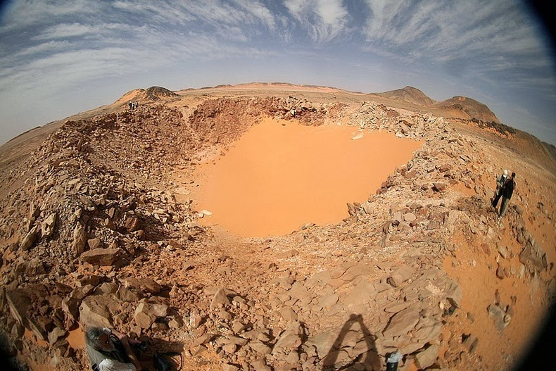
An Italian researcher discovered the Kamil Crater using satellite imagery in yet another Google Earth discovery. The world's most preserved crater may very well be this one. Normally, craters fade away over time, but bedrock has preserved the Kamil Crater.
A 45 m-diameter impact crater called Kamil was discovered in southern Egypt in 2008. It was produced by the Gebel Kamil iron meteorite's hypervelocity impact on layered sandstones with subhorizontal bedding, a sedimentary target. A variety of shock features typical of target rocks rich in quartz can be seen in ejecta samples found in Kamil Cater.
According to their frequency at the thin section scale, they have been separated into two groups: pervasive shock features, which are the most frequent, which include fracturing, planar deformation features, impact melt lapilli, and bombs, and localized shock features, which are the least frequent, which include high-pressure phases and localized impact melting in the form of intergranular melt, melt veins, and melt films in shatter cones. The smallest impact crater known to have reported shatter cones, coesite, stishovite, diamond, and melt veins is Kamil crater.
Pervasive shock features infer that the maximum shock pressure was between 30 and 60 GPa based on experimental calibrations that have been documented in the literature. Kamil is a perfect environment for studying impact cratering and shock deformation processes in small impact structures because of the variety of shock features it contains and how recently it occurred.
- Where: Kamil Crater, Egypt
- Year of Discovery: 2008
amusingplanet.com 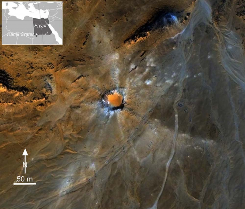
meteorite-times.com -
US aerial photographers reported seeing an unusual shape in the Teifi River area's waters in 2009. According to research by Dr. Ziggy Otto of Pembrokeshire College, a Welsh community built an 800-foot structure to aid in fishing in the 11th century. On Google Earth, a gigantic fish trap that was constructed during the Norman Conquest and intended to trap fish behind rock walls was discovered.
This enormous medieval fish trap was discovered in a Pembrokeshire estuary in Wales after being spotted in aerial photos taken by Google Earth. Experts speculate that the 260 m (853 ft) long artificial V-shaped structure could be more than 1,000 years old. They believe it was built to catch fish that migrate, like salmon and sea trout, as they ascend the River Teifi at Poppit in Pembrokeshire. Research is being undertaken between Pembrokeshire College and the Dyfed Archaeological Trust to find out more.
Although the water in it would have been shallower 1,000 years ago, when the sea level was lower, the structure is about 3 feet wide and extends about 12 inches above the underwater sand. Fish would have swum into the estuary, but as the water receded with the ebbing tide, they would have become trapped in the structure.
- Where: Teifi River area's waters
- Year of Discovery: 2009
lolwot.com 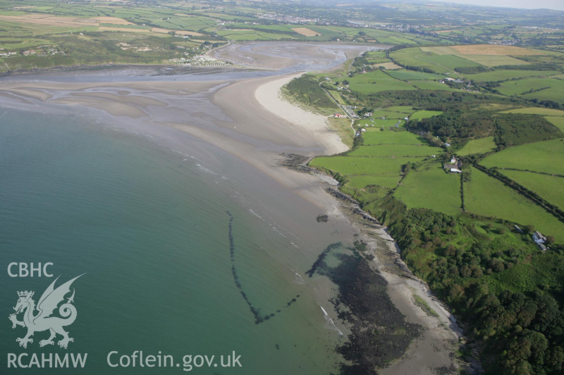
coflein.gov.uk -
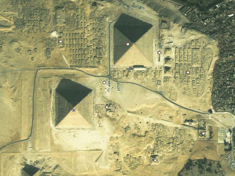
Two undiscovered pyramids in Egypt were discovered by a researcher using Google Earth. The two potential complexes are situated in Upper Egypt, about 90 miles apart from one another (the southern part of the country). The sites contain unusual mounds with noteworthy features, according to a Google Earth Anomalies post by satellite archaeology researcher Angela Micol.
One of the complex sites contains a distinct, four-sided, truncated, pyramidal shape that is approximately 140 feet in width. This site contains three smaller mounds in a very clear formation, similar to the diagonal alignment of the Giza Plateau pyramids.
The second potential location has four mounds and a larger plateau with a triangular shape. At this location, there are two larger mounds that are roughly 250 feet wide, and two smaller ones that are roughly 100 feet wide. The large plateau, or butte, nearby, with a width of about 600 feet, is arranged in a very distinct formation with this site complex.
Satellite archaeology researcher Angela Micol of Maiden, North Carolina, has documented and found the sites. For more than ten years, Angela has used satellite imagery to conduct satellite archaeology research, looking for ancient sites from space. Archaeology is Angela's field of study, and she graduated from UNC Charlotte. She has been able to record numerous potential archaeological sites thanks to Google Earth, including a potential underwater city off the Yucatan peninsula that has attracted the attention of scientists, researchers, and archaeologists. Don J. Long and Bill Donato have helped Angela.
- Where: Egypt
- Year of Discovery: 2012
dailystar.co.uk 
youtube.com -
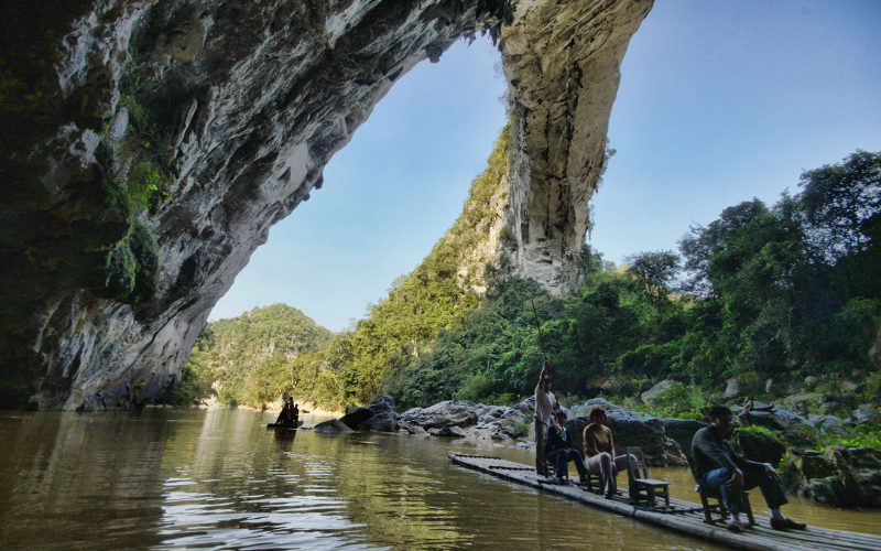
The Natural Arch and Bridge Society was established by Jay Wilbur, an aerospace engineer, in 1988 for like-minded enthusiasts. In 2009, Wilbur was astounded by what he discovered while searching Google Earth: a rock span over China's Buliu River that neither a travel guide nor anyone at NABS had ever heard of, but that seemed to dwarf any of Utah's arches. Due to its dramatic and otherworldly appearance, the locals refer to it as "Fairy Bridge"—Xian Ren Qiao.
If it weren't for an American arch enthusiast and climber named Jay Wilbur's knowledgeable eye and diligent research, the largest natural arch in the world, at 120 meters, might still be hidden in secluded China from the majority of the world.
NABS found it challenging to reach and measure Xianren Bridge. It is located in the rough karst region of southern China, 25 miles north of the nearby town of Fengshan. To get to the bridge from upstream, it takes three hours and several rapids in a rubber raft. You can board bamboo rafts that locals will pole upstream to the bridge from downstream and ride there. The span of the Xianren Bridge was measured by NABS surveyors in 2010, making it the world's longest arch or bridge by a significant margin at 400 feet.- Where: Xianren, Guanxi Autonomous Region, China
- Year of Discovery: 2010
naturalarches.org 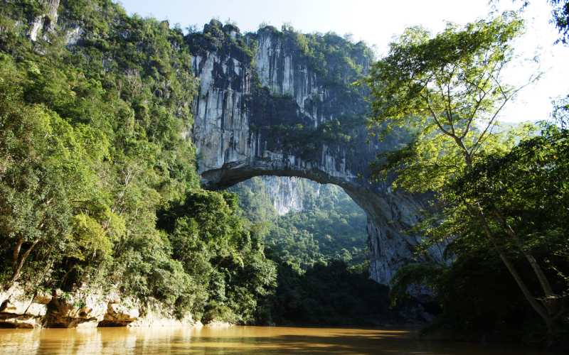
naturalarches.org