Top 15 Strangest Places on Earth You Won’t Believe Exist

There are a lot of places on earth that are genuinely strange and mysterious, whether they are caused by nature, haunted forests, abandoned villages, or ... read more...something else entirely. The surprises that exist on Earth continue to astound us as time passes. The strangest places on earth, along with information on where to find them, are listed below.
-
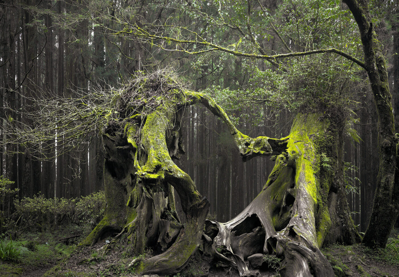
The Hoia Forest, which is located in Cluj-Napoca, Romania, is thought to be the most spooky forest in the entire world. As a result of the numerous strange disappearances that have occurred, Romania has been called the Bermuda triangle of Europe.
Numerous visitors to the forest have reported strange occurrences like faces in pictures, sightings of UFOs, and a sense of being watched. Strange symptoms, including nausea and anxiety, have been reported by visitors to the haunted forest. They experience severe head pain, strange rashes, and electronic device failure.
The spookiest forest in central Romania is the Hoia Forest. It has additionally been referred to as the world's most eerie forest. Additionally, The Clearing is a very scary location in the forest. Many instances of hearing female voices laughing and breaking the silence have been documented. Many people think it's a portal to another dimension.
Location: Cluj County, Transylvania, Romania
MyBestPlace 
News.com.au -
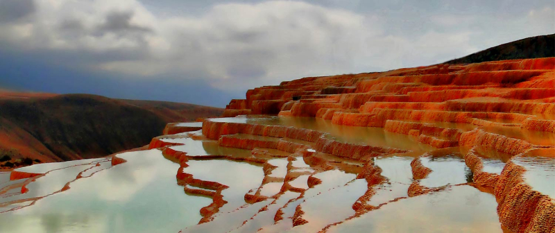
Badab-e Surt's one of the most uncommon, wonderful, and odd places on earth, and it's in Iran. Water pools iridescently collect on rust-colored travertine beds. Colorful puddles cover each layer of rock at Iran's Badab-e Surt, transforming the naturally formed terraces into an exquisite sight ablaze with fiery hues. The scenery is stunning.
Badab-e Surt is a rare geological masterpiece that was formed between the Pleistocene and Pliocene epochs. There are only a few places like this in the world. A comparable natural wonder has already perished.This location was created by nature as a result of two different mineral hot springs bubbling water down the mountain from above 6,000 feet for thousands of years. The carbonate minerals in the water were left behind as it cooled, forming a jelly-like substance that later hardened to give the slope its current staircase-like shape.
One of the hot springs spouts salty water with purported therapeutic benefits. It is purported to treat illnesses like rheumatism and specific skin conditions. The water's lovely orange tint is caused by the other spring, which spews a sour sediment rich in oxide. Combining the Persian words for "gassed water" and the former name of the neighboring village, which means "intensity," gave rise to the name of the location.The puddles glow with the red, orange, and yellow tones found in the underlying rock when the light hits the terraces just right. Sky and cloud reflections will occasionally add swirls of blue and gray to the mix, creating a watercolor palette bursting with rich natural hues.
Even though Badab-e Surt can be challenging to find, it's a location worth looking for. Nearly 60 miles separate it from Sari City. There are long stretches of unpaved mountain passes and winding, isolated roads to get there.
Location: Mazandaran Province, Northern Iran
SURFIRAN 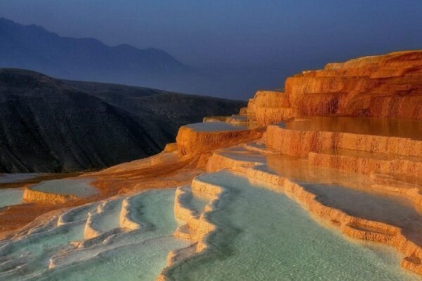
Mehr News Agency -
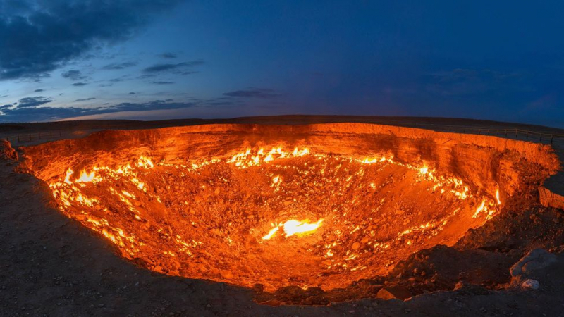
Door To Hell - a 230-foot-wide hole in Turkmenistan's hot, expansive Karakum desert, near the 350-person village of Darvaza, has been on fire for more than 50 years. Though technically known as the Darvaza gas crater, locals refer to it as "The Gates of Hell." Its blazing glow can be seen for miles.
In 1971, a Soviet drilling rig accidentally punched into a massive underground natural gas cavern, causing the ground to collapse and the entire drilling rig to fall in. Poisonous fumes began leaking at an alarming rate after a gas pocket was punctured.
The Soviets lit the hole on fire in an effort to prevent a potential environmental catastrophe, believing it would burn out in a few weeks. The fiery pit is still active after many years. On the other side of the "Gates of Hell," the Soviet drilling rig is thought to still be there.
Amazingly, people still travel into the desert to see the crater in all its blazing glory despite its ominous name and constant flames. Wild camping has become popular in the nearby desert.
However, the burning crater's future might be uncertain. President Gurbanguly Berdymukhamedov issued an order to the Turkmenistan government in January 2022 to start looking into ways to put out the fire.Location: Karakum desert,Turkmenistan
BBC 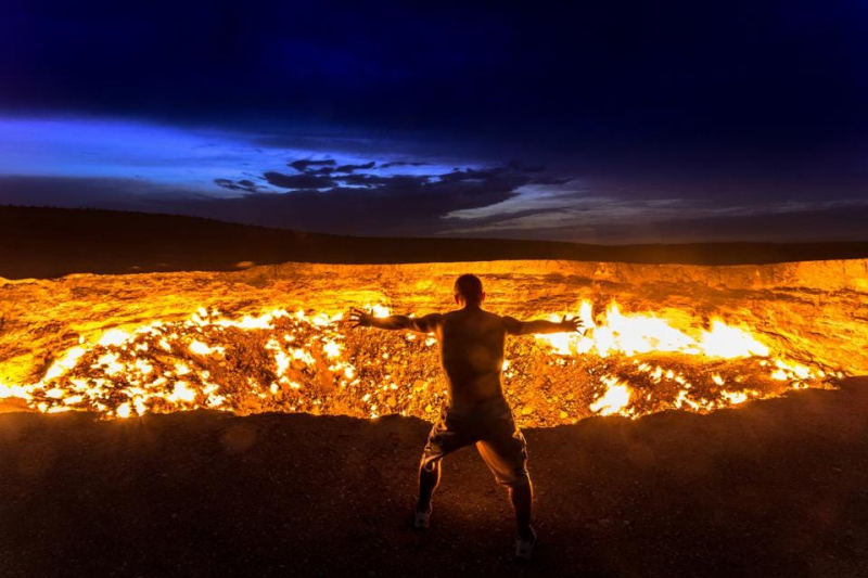
Forbes -
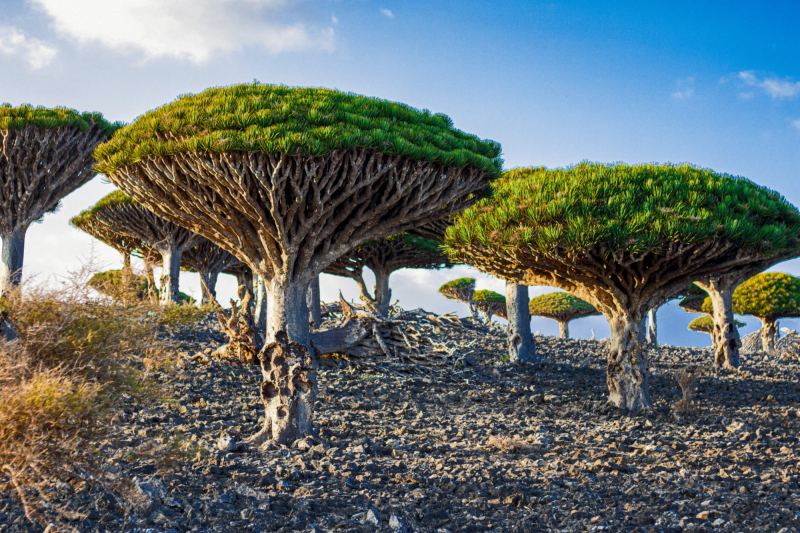
One of those unusual places on Earth is Socotra. The archipelago, which is sandwiched between Yemen and Somalia, has managed to stay isolated, preserving its incredible biodiversity, including the dragon tree, which has come to serve as one of the region's symbols.
Socotra is referred to as the Galapagos of the Indian Ocean because it is home to a variety of unique plants and animals. It makes sense to draw comparisons to the South American island, but Socotra is also home to some of the most breathtaking landscapes that give the impression that one is on another planet. Despite its distinctiveness, there are still many unanswered questions about the archipelago.When researching Socotra, many visitors' first concern is whether the area is secure. Despite being a part of Yemen, the archipelago is far from the civil war that has been raging there since 2014, making Socotra a safe place to visit. Unsurprisingly, the war has an impact on travel and tourism in the nation. For years, locals have observed tourists leaving the island. Slowly but surely, things are changing, and the island now only sees 3,000 tourists annually, making it an exciting vacation spot for those seeking a getaway from the tourist crush. When visiting Socotra, it is required to work with an agency, and they will be in charge of making all the arrangements.
Because of its rich natural resources, UNESCO designated Socotra as a World Natural Heritage site in 2008, and the island became known as the "Galapagos of the Indian Ocean." Socotra has over 800 plant species, including the amazing dragon's blood trees, and nearly 40% of them are unique to the island. Animal numbers are even more impressive, as Socotra is home to more than 90% of the archipelago's reptile species. It is undeniably a landscape that the traveler will not find anywhere else.
Socotra is home to nearly 60,000 people spread across the coast and mountains. They have been isolated for many years because paved roads and the airport are relatively new, allowing the island to be preserved.
There are two methods for getting to Socotra. One is to take a plane to Yemen's capital, Sanaa. The second involves departing from Dubai on a nonstop flight. Every Monday at 10 a.m., a flight departs Abu Dhabi, Dubai, and continues directly to Socotra. However, travelers cannot book these flights directly online; instead, they must go through an agency that will also handle the Visa arrangements. A seven-day tour will also be organized by the agencies; payment for this must be made at least two weeks in advance. Considering that they frequently have to sleep in tents, visitors shouldn't expect opulent accommodations.
Since Muslims make up the majority of the population in Socotra, modest attire is encouraged, especially when visiting villages. When in the city, women should cover their shoulders, knees, and hair with a scarf. Men should also cover their legs, so t-shirts and trekking pants are appropriate choices. In addition, it is advised to bring a hat, hiking boots, sunscreen (which is crucial to bring because it is not available on the island), tissues, a swimsuit, and warm clothing for the evening.
Location: Socotra island, Yemen
middleeasteye.net 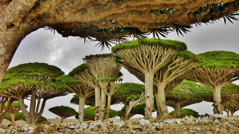
welcometosocotra.com -
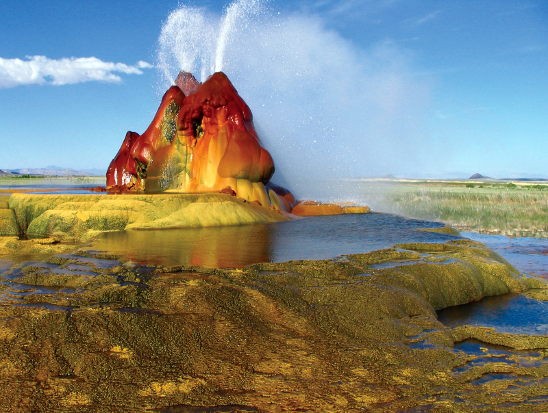
The Fly Geyser in Nevada is an unintentional man-made wonder that has produced a fantastically shaped and whimsically colored desert wonder that is a must-see for both locals and tourists. The Burning Man Project acquired the 3,800-acre Fly Ranch in Northern Nevada, home to the Fly Geyser, in 2016. It is a breathtaking location on the edge of the Nevada Black Rock Desert, about two hours north of Reno.
When locals drilled a well in search of irrigation water in 1916, the first geyser on the location started to form. The first geyser was created when this well was quickly abandoned after it was determined that the water inside was too hot. A geothermal power company drilled a test well at the location in 1964, which led to the unintentional creation of the main geyser. Later newspaper reports claimed that the well had either been improperly plugged or left uncapped. In either case, the well hole erupted with scalding hot water, and calcium carbonate deposits started to form. These deposits grew by several inches every year.
After several decades, those deposits have grown into three large mounds that rise from a field of tall reeds and grasses. The sediments have grown to nearly 6 feet in height and are multicolored green and red. The geyser's trio of travertine cones continue to spew scalding hot water into the air about four or five feet up. Scientists who have studied the geyser have discovered that the coloring on the outside of the mounds is caused by thermophilic algae, which thrives in moist, hot environments.
According to research, the inside of the mounds contain quartz, and this quartz is growing much faster than any of the other geysers she has studied in her career. Typically, quartz does not begin to grow within geysers for about 10,000 years, making the Fly Geyser even more remarkable.
The Fly Ranch Geyser is situated in Northern Nevada, roughly 20 miles via State Route 34 north of Gerlach, Nevada (a well-liked stop along the Burner Byway). The Fly Geyser can be seen clearly from the side of the road, and its hot water plumes are visible for miles around.
Location: Washoe County, Nevada, USA
Wikipedia 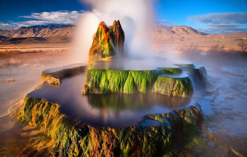
WonderOUT -
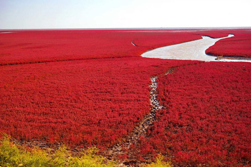
Prepare your cameras. Red Beach is found in Panjin, a city in the Liaoning province of China, about a six-hour drive from Beijing. But despite the name, there isn't any sand to be found here.
The area is located in one of the largest wetlands in the world, which mysteriously transforms into a stunning red color every autumn, according to Smithsonian Magazine. Well, it's not magic. It turns red because a species of seepweed grows there and has a high saline absorption capacity. It turns crimson as it absorbs the seawater from the surroundings.The seepweed initially appears green in the spring, but over the course of the summer, it gradually turns another shade, eventually turning a deep red in the fall.
Every fall, a large number of tourists - more than two million, according to CNN - flock to the region for the stunning scenery and, of course, photo opportunities. Aside from Red Beach, the region is home to 260 bird species and is well-known for rice and bamboo shoots.
Depending on where you are in mainland China, you can get to Panjin by bus or train. When you arrive, take the designated walkway through the wetlands to enjoy the beach's beauty.And every fall, a large number of tourists - more than two million, according to CNN - visit. The best time to visit the lovely beach is in October. If you arrive too early, the seepweed will be less red, and if you arrive too late, they may have died off for the year.
Location: Dawa County, Panjin, Liaoning, China
Travel + Leisure 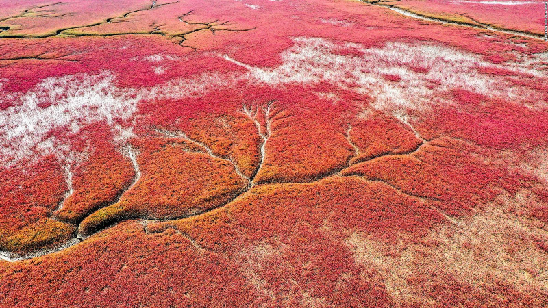
CNN -
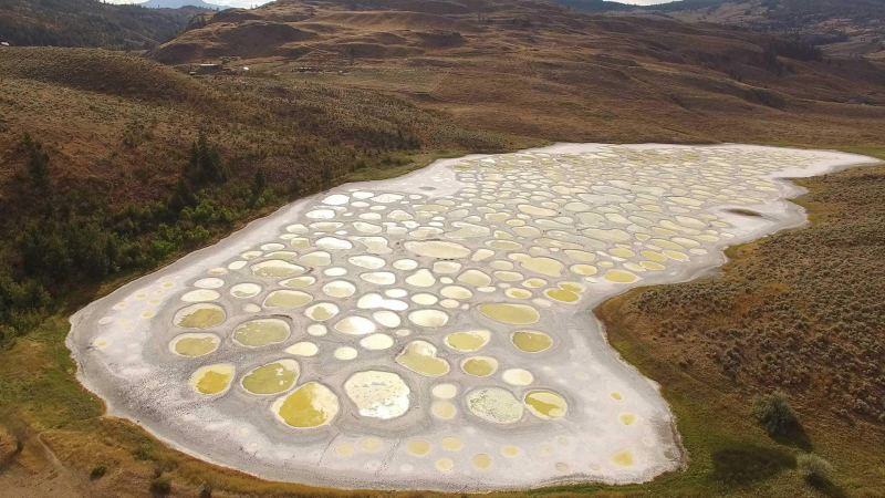
The Okanagan Valley lake, northwest of Osoyoos, British Columbia, resembles any other body of water in the winter and spring. However, hundreds of enormous salty pools are left behind in the summer as the majority of the water begins to evaporate, creating a polka-dotted landscape of yellow, green, and blue spots. The appropriately named Spotted Lake is referred to by the CBC as "the most magical place in Canada."
A significant amount of minerals, such as calcium, sodium sulfates, and magnesium sulfates, have accumulated in the water, creating vibrant pools. From nearby hills, minerals and a variety of salts have run off. The concentration of minerals in each pool determines the different colors.
The indigenous people of the Okanagan Nation have revered Spotted Lake for centuries, according to the British Columbia Visitor Centre. They believed that each of the various circles possessed unique healing and medicinal properties. The lake was originally known as Kliluk by the Okanagan Valley's First Nations.
Minerals from the lake were used to make ammunition during World War I. Laborers mined up to one ton of salt from the lake each day to extract the minerals. According to the British Columbia Visitor Centre, the lake "displayed an even greater variety of colors and an even greater artistic beauty" prior to this mineral mining.
Visitors who want to see the lake from a distance cannot get too close. A fence has been erected to protect the area, along with a sign stating that it is culturally and environmentally sensitive. However, there are numerous vantage points along the highway from which to view the lake's famous polka dots.
Location: Eastern Similkameen Valley, British Columbia, Canada
CBC 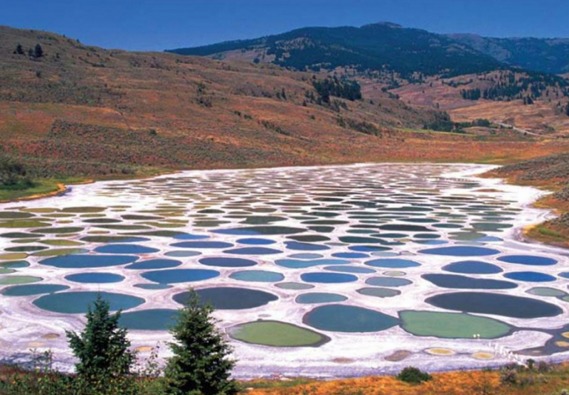
MyBestPlace -
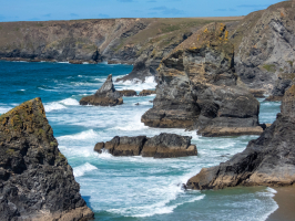
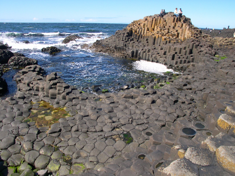
The coastline of Northern Ireland is anything but modest. One breathtaking site follows another as you travel along the well-known Causeway Coast.
Among the many wonderful attractions are the hulking castle ruins of Dunluce Castle, the white-cream sands of Whiterocks Beach, and the breathtaking views from the Carrick-a-Rede rope bridge. One sight, however, stands out as truly spectacular as you wind your way along this wonderful driving route: the Giant's Causeway.
Standing on the hills that gently arc this extraordinary location, you can see thousands of basalt columns plunging into the Atlantic from above. It's a breathtaking sight, with a whopping 40,000 or so of these stepping stones in hexagonal shapes that originate from a volcanic age roughly 60 million years ago.Step inside the Giant's Causeway Visitor Centre to learn about a story that is central to this UNESCO World Heritage Site. Fionn mac Cumhaill (Finn McCool) is the show's star, an Irish giant who chose to fight Scottish big man Benandonner. According to legend, the giants despised each other. So, after enduring insults from Benandonner, Fionn built a path to use as stepping stones to reach Scotland, which Benandonner then ripped up. As a result, the Giant's Causeway was formed.
And what a truly unique location it is. An enjoyable walk of less than a kilometer will bring you down to the Causeway itself, where you can hop over the stones, explore the surrounding hills, or simply sit and reflect on the perplexing geology that has resulted in one of Europe's most remarkable natural sites. The light changes throughout the day, changing from sharp greens and greys to warm tobacco brown. It's the stuff that dreams are made of.
Location: County Antrim, Northern Ireland
Wikipedia 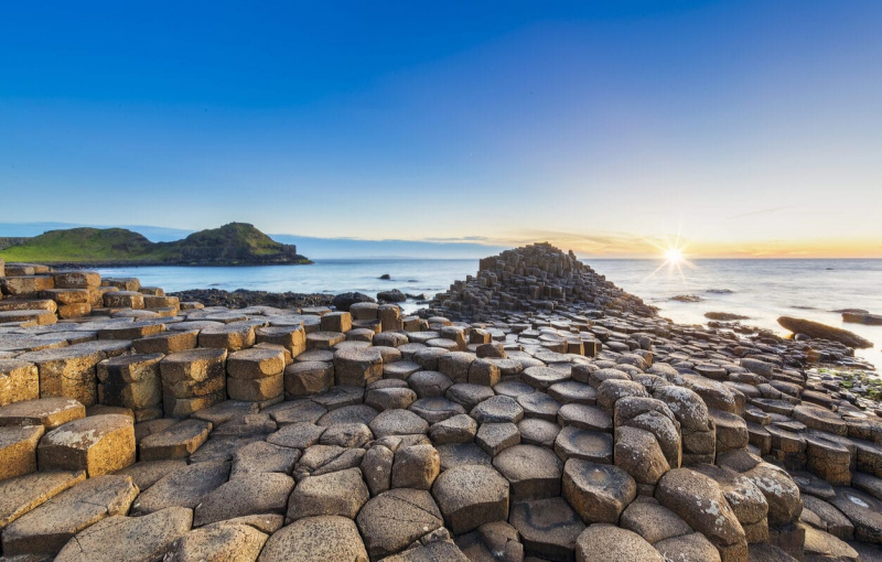
Escales - Ponant -
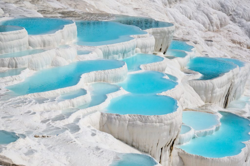
Two fascinating sites in Turkey that are part of the UNESCO World Heritage are Pamukkale and Hierapolis. Pamukkale is well-known for the breathtaking white travertine terraces that once supported Hierapolis, a significant center of trade and culture. The name comes from the hot springs, which discharge mineral-rich water onto the landscape below, creating a distinctive structure that resembles a cotton castle.
The travertines at Pamukkale are white as a result of a natural process in which calcite-rich water flows from hot springs and is deposited on the hills below, resulting in these pristine terraces.
Pamukkale travertines are a natural phenomenon that changes over time. Some Pamukkale pools lose water, while others gain it. Despite the fact that much of the water was diverted to the town for human consumption.
In the 1980s, there was a road that brought tourists directly up the slope of the Pamukkale travertines from the town. Fortunately, that road was decommissioned in the 1990s when a series of artificial pools were built in its place. In addition, the local government bulldozed many hotels built directly next to the travertines and turned the area into a park.The travertines in Pamukkale are similar to a hot spring in that hot thermal water flows down the hill, creating pools that you can bathe in. Other hot springs in the area include Cleopatra's Antique Pool and the Red Springs of Karahayit. Pamukkale means "cotton castle" in Turkish, and it got its name because hot springs released mineral-rich water onto the hilly landscape below over time, forming a unique natural structure that resembles a cotton castle.
Since Pamukkale is extremely crowded in the summer, the best times to visit are in the spring (April through May) and fall (Sep through October), when the weather is pleasant and there are fewer tourists. On the other hand, if you want to avoid the crowds and visit Pamukkale in the summer (Jun - Aug), it is best to arrive as early as you can. Given that we visited Pamukkale at the end of October when the daytime temperature was still very high and the water was warm, spring and fall should still be pleasant times to travel there.
If you visit Pamukkale in the early morning, as we did, be prepared to be cold on your feet because you must walk barefoot over the cold rock. It will take a few minutes if you enter from the side of town to reach the section where the flowing water becomes warmer.
Location: Denizli Province, Southwestern Turkey
Travel Talk Tours 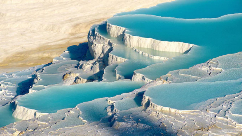
The Telegraph -
Aoshima is a unique cat island in Japan. There are several reasons for this, but one stands out as soon as you step off the boat, with a meowing welcome committee rushing up to greet you: the local feline population density. Only a few years ago, this tiny island was home to an estimated 200 cats. There are a variety of breeds represented, with an overwhelming majority of orange and brown tabbies, as well as calicos.
You might assume that a small island like Aoshima doesn't have a lot to offer. and you are correct. Imagine, however, spending time with a group of amiable meowing and purring cats, strolling around the island with them by your side, or simply relaxing while your furry friends lazily play, stretch, and sleep while you take in the serene waters of the Seto Inland Sea. Aoshima is unquestionably a cat lover's paradise.
Because Aoshima is not a popular tourist destination, it is critical to respect the island's tranquility as well as private property. Some locals may enjoy interacting with visitors, while others simply want to live in peace. Also, Aoshima has no accommodations, shops, cafes, or vending machines, so bring everything you might need and take your garbage with you. Local residents feed the cats every day, so they don't have to beg for food. However, feeding the cats is always a pleasant experience for visitors, so feeding is permitted within a designated area to avoid disrupting port activity and disturbing the residents. Just make sure to bring only cat food and feed them in moderation to prevent making them ill. Food isn't the only thing that can make a cat happy, though; giving them toys to play with is also a good idea.
Aoshima evolved into a "cat island" entirely by chance. It was once a bustling fishing village whose livelihood was based on a sardine fishery, where cats were introduced to hunt mice. The island's fishing activity and human population declined over time, but the cats survived and thrived. Following the discovery of the island by some cat lovers, word-of-mouth spread, which was then greatly amplified by the Internet (the other cat paradise). This propelled the small sleepy island to international prominence as the cat island, attracting both Japanese and international visitors.
Location: Aoshima Island, Japan

The Atlantic 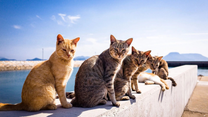
Rove.me -
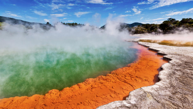
A geothermal area to the north of New Zealand is home to the famous Wai-o-Tapu Thermal Wonderland. The "Champagne Pool" can be found here, so named because of the infinite bubbles produced, giving it the appearance and feel of a champagne tub.
The Champagne Pool is part of an extraordinary volcanic lake that has a diameter of 65 meters and a depth that is nearly equal to that. It has a geothermal fluid volume of approximately 50,000 cubic meters of water and gas. The deepest waters of the Champagne Pool reach temperatures of around 500°F, while the surface reaches temperatures of around 160°F. The natural gases produced are primarily carbon dioxide (CO2), with minor amounts of nitrogen, methane, hydrogen, and oxygen.
Due to the presence of dissolved minerals in the water at extremely high temperatures, which results in incredible colorful palettes with shades of electric green to deep reds, it was created as the result of a hydrothermal eruption 900 years ago.
The Waiotapu Spa Reserve's name translates to "sacred waters." It is located about 19 miles from Rotorua, the Maori population's center. Unquestionably one of the world's seven wonders, it has been designated a protected area since 1931. It is a potent location with a surreal atmosphere that offers breathtaking views that far exceed the capacity of even the most vivid imagination.Location: Waiotapu, North Island, New Zealand
New Zealand 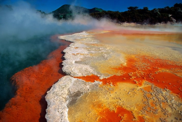
PandoTrip.com -
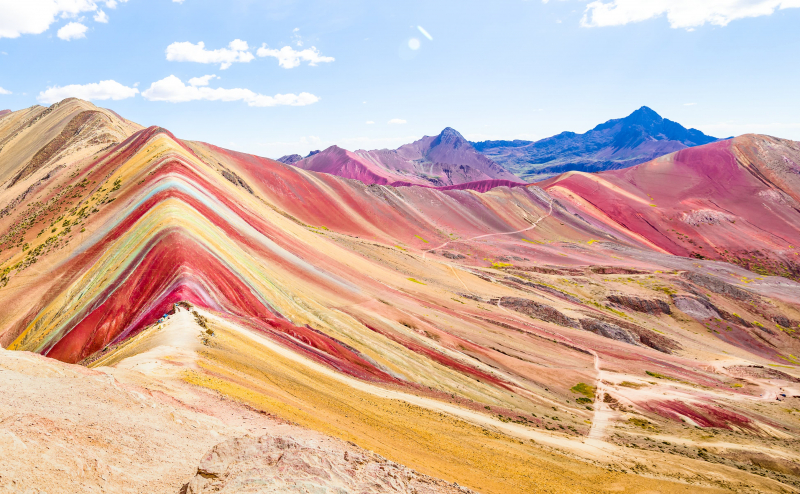
There are numerous reasons to visit Peru, from its diverse natural geography to its cultural festivals and ancient civilization ruins. Vinicunca, also known as Rainbow Mountain or the Mountain of Seven Colors, was discovered four years ago when the snow covering it melted, revealing the natural beauty of the rock beneath. The mountain's unique mineralogy, formed over time by weathering, environmental conditions, and sedimentary deposits, created a marbling effect, with layered hues of gold, lavender, red, and turquoise towering into the sky.
Due to local tour companies and a flurry of Instagram posts, the mountain, which is revered as a holy site in Peru, has gained popularity among foreign tourists and is now the second-most visited attraction in the Cusco region. A third of Machu Picchu's daily visitors, or 1,500 people, are said to visit Vinicunca each day, according to Peruvian media.
Due to local tour companies and a flurry of Instagram posts, the mountain, which is revered as a holy site in Peru, has gained popularity among foreign tourists and is now the second-most visited attraction in the Cusco region. A third of Machu Picchu's daily visitors, or 1,500 people, are said to visit Vinicunca each day, according to Peruvian media.
Hikers who want to climb the mountain should plan on a five-mile round trip from the bus stop. Vinicunca is more than 16,000 feet above sea level, so visitors should be prepared to climb to high altitudes. The majority of the path is not difficult, but the final section of the hike is a more difficult, steeper incline.
Mountain bikes can be rented for thrill seekers or as an alternative way to see Vinicunca in all its glory. For visitors who prefer not to walk long distances, the journey can be taken on horseback for 80 soles. If walking becomes too difficult, horses can be rented at several points along the route.Vinicunca trekking is best done between March and November, with the best chances of clear skies being from June to August. However, the weather on the mountain can change quickly.
Location: central part of Andes, Southern Peru
CNBC 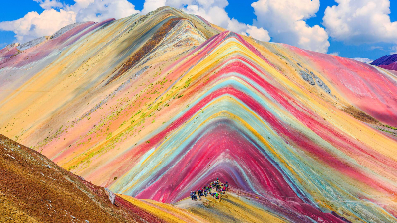
Perú Travel -
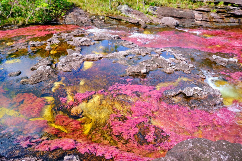
Because of the variety of hues visible beneath its crystal-clear waters, Caño Cristales in Colombia's Serrana de la Macarena National Park is also known as the "river of five colors," "liquid rainbow," or "melted rainbow." Bright greens, yellows, reds, and purples may appear to flow down the river in specific lighting and water conditions. The river can occasionally also appear to be a vivid blue, hot pink, orange, or deep maroon.
Despite appearing magical, the vivid color is actually the result of an aquatic plant called Macarenia clavigera, which is not an algae or moss. Which colors you can see in the water depends greatly on the water level and the surrounding environment.
Macarenia clavigera clings to the riverbed's billion-year-old quartzite rocks. It can be found in a few rivers throughout Serranìa de la Macarena (hence its name), but Caño Cristales provides just the right conditions for it to reach peak brightness. The best time to visit is when the sun is shining brightly and reflecting the colors. The water level must be high enough for the plants to thrive (rather than drying out and turning brown), but not so high that the river bottom cannot be seen. Colors are generally at their most vibrant between July and November.
Travelers must fly into Villavicencio in central Colombia before hiring a different aircraft to travel to La Macarena to reach the river. The fairly remote mountain range of Serrania de la Macarena, which offers access to the river, is reachable from there by hiring a guide.
Location: Serranìa de la Macarena National Park, Colombia
Cartagena Explorer 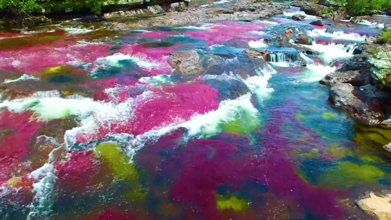
Business Insider -
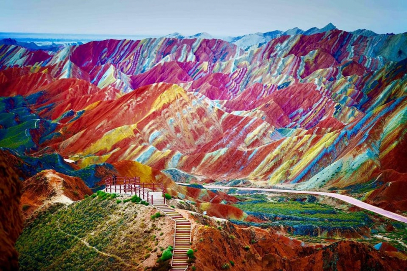
The Zhangye National Geopark is situated in northern China, halfway along the country's border with Mongolia. It is situated in the Qilian Mountains' foothills. The national park spans 124 square miles of land (322 sq km). The stunning display of colors across hills and rock formations is what makes the national park, which was formerly known as Zhangye Danxia Geopark, so well-known. The area was named one of China's most breathtaking landscapes by the Chinese media.
Linze Danxia Scenic Area is the park's most popular and developed area. Binggou is another area along the Liyuan River. Although it receives fewer visitors, it provides additional views of breathtaking landscapes. Sunan Danxia Scenic Area is the third area.
The rocky outcrops and undulating hills almost appear painted. The scenery is fantastical. It's safe to say that Zhangye National Geopark is the world's most vibrant national park. Sandstone and minerals were layered on top of one another over time, and as tectonic plates shifted, angled painted layers appeared on the rock formations and sandstone rolling hills. This is how the colorful landscapes were produced. The rock formations and rolling hills have been further sculpted by rain, wind, and time into a variety of displays of pillars and ravines. Together, tectonic plates and erosion have produced amazing patterns that can be seen by everyone.
The most picturesque landscapes are the multi-colored rock formations and naturally painted foothills that blanket the area. It's difficult not to wonder if the landscapes were enhanced with colored sand.
The park includes a network of boardwalks that allow visitors to meander through the vibrant sandstone landscapes. The boardwalks are level, allowing wheelchair users and other physically challenged visitors to enjoy the splendor.Location: Zhangye, Gansu, China
Forbes 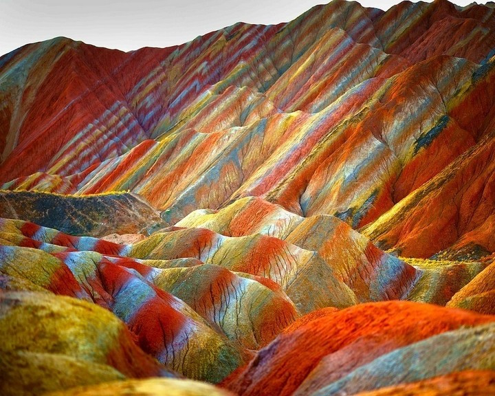
Tourism on the Edge -
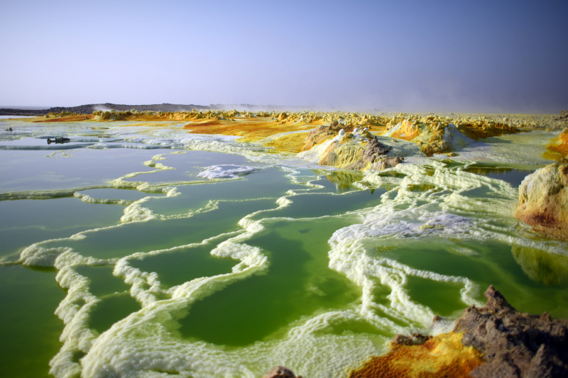
One of the strangest places on earth, it has been referred to as a "gateway to hell" and a true "land of death." The Danakil Depression's sulfurous hot springs, acid pools, steaming fissures, and salt mountains look like they belong in a science fiction film. But the location is real, and it's a popular tourist destination in Ethiopia. The Danakil Depression draws salt miners, scientists, and travelers. It is one of the hottest places on Earth (by average daily temperature) as well as one of the lowest (more than 400 feet below sea level). Miners travel hours, often by camel caravan, to extract salt slabs from the flat pans around Lake Afar, as they have for centuries. Salt is the region's "white gold," and it was used as money in Ethiopia until the twentieth century.
Visitors are drawn to the Danakil Depression for a completely different reason. It's a hot, foul-smelling, punishing place, which is why people travel across continents to see it. Despite its difficulty, those who make the journey rave about it. Dallol's sulfur springs are particularly appealing, with their stupefying shades of neon green and yellow that hiss forth from the rocky terrain. Erta Ale (meaning "Smoking Mountain" in the local Afar language) is another, with its cartoon-like molten center and one of only eight lava lakes in the world.
Danakil is located in the Afar Triangle, a geological depression in Ethiopia's remote northeastern region where three tectonic plates are slowly diverging. The area is large (124 miles by 31 miles) and used to be part of the Red Sea. Volcanic eruptions emitted enough lava overtime to seal off an inland sea, which evaporated due to the arid climate.
It's scorching outside. Daily temperatures average around 94 degrees Fahrenheit (34.4 degrees Celsius) but can reach as high as 122 degrees Fahrenheit (50 degrees Celsius), and rainfall is scarce. Day trips departing from Wikro typically begin around 4 a.m. From there, a four-wheel drive convoy begins a three-hour journey across the Ethiopian portion of the Great Rift Valley on a winding mountain road. For a faster route, helicopter rides are also available.
Travelers from all over the world have long been inspired by nature's changing hues, from autumn foliage excursions to cherry blossom season. But what really strikes me about this place is the variety of natural colors, set against a vast expanse of nothing. The rain and seawater from the nearby coasts seep into the sulfuric lakes where they are heated by the magma, resulting in a mixture of yellow, orange, red, blue, and green. These brilliant colors start to appear as the sea salt reacts with the minerals in the magma. As the water evaporates in the heat, colorful crust-like deposits from all over the place and mysteriously blend with the depression's turquoise lakes, which are cooler.
The high season in the Danakil Depression lasts from November to March, when temperatures, though still in the 90s F, are slightly more bearable. From June to August, the weather is described as "unsuitable," and tours are still available, but the experience is often more arduous than pleasurable. It truly is one of the most alien places on the planet. It is one of the planet's most remote, unlivable, hottest, and lowest points. Sounds a little scary, but that's what makes it so intriguing.
Location: Afar Triangle, Ethiopia
The New York Times 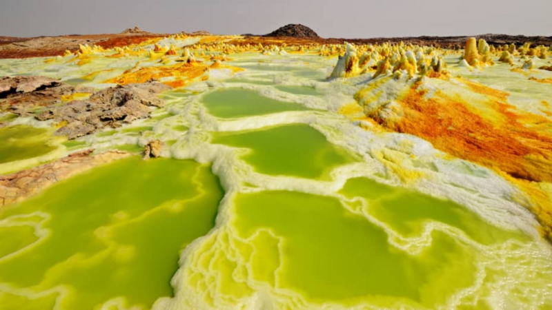
CNBC