Top 12 Most Beautiful Islands in Russia

Russia's tourism industry has grown rapidly since the end of the Soviet era, first within the country and then internationally, fueled by its rich cultural ... read more...heritage and natural diversity. In particular, the Russian archipelago is also a good choice. Let's find out the 12 most beautiful islands in Russia now!
-
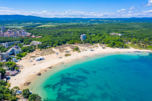
Sakhalin is sometimes regarded as the "end of the world" island. Half of Sakhalin belonged to Japan after the Russian–Japanese conflict of 1905, and the other half to Russia. Following WWII, the entire island was annexed by the Soviet Union. Sakhalin is now part of the Russian Federation and is the country's largest island.
Sakhalin has a population of about 500,000 people. One-third of the population lives in Yuzho-Sakhalinsk, the island's largest city. The island's winter lasts 7 to 8 months, and the island's brief summers are usually cold and windy. Sakhalin is wealthy in oil, gas, gold, and coal, with some of the world's largest offshore oil and gas operations. Nonetheless, there are a number of huge preserves with pristine animal sanctuaries and ecotourism resorts.The Sakhalin Regional Museum is housed in a pagoda-style edifice in Yuzhno-capital. Sakhalinsk's Indigenous artifacts and a large paleontology collection are on display. The Chekhov Book Museum, located nearby, is dedicated to writer Anton Chekhov's time on the island. The Sakhalin Art Museum, housed in a grand 1930s edifice, specializes in 19th-century Russian art.
Location: Russian Far East, Northern Pacific Ocean
Population: 489,638
Area: 72,492 km²
Source: Russia Beyond Source: alenkovvv -
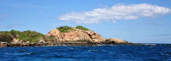
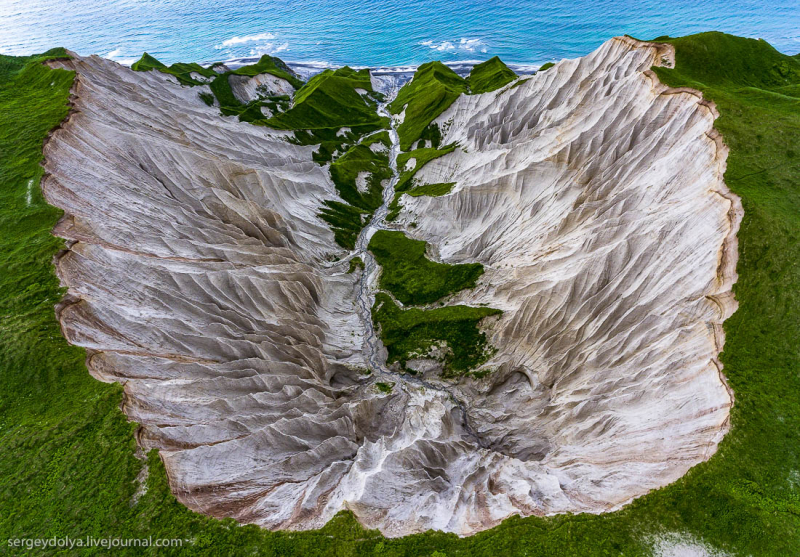
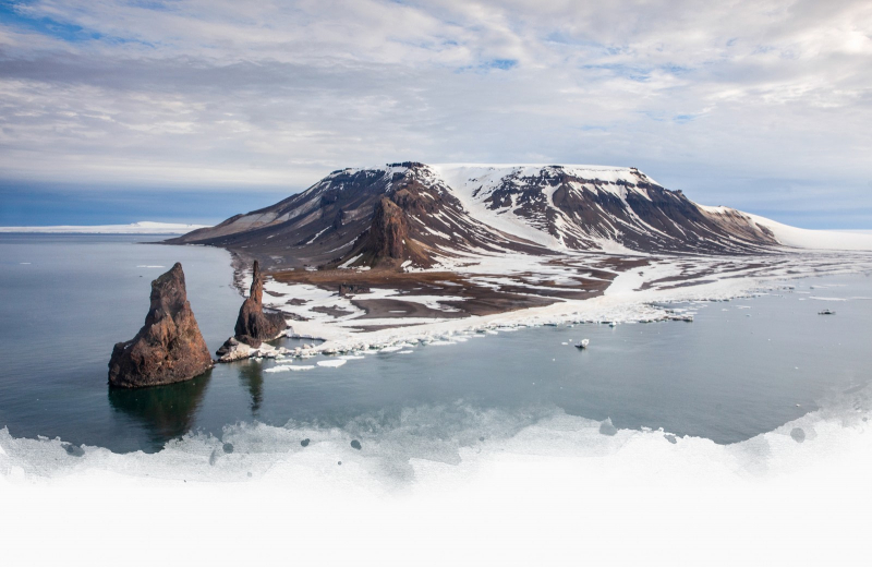
Iturup is the largest of the lush and beautiful Kuril Islands, which stretch from Kamchatka's southernmost point to the Japanese Islands, with the Pacific on one side and the Sea of Okhotsk on the other. It's a land of azure lagoons, long waterfalls, and active volcanoes for the youthful at heart. Iturup Island ranks the second place on our list of the most beautiful islands in Russia.
All islands are produced when volcanoes erupt from the sea, but there is still a particular, residual "lava country" in this area of the Kuril Islands, and it is possible to trace what the archipelago looked like millions of years ago.
There are nine active volcanoes on Iturup, as well as one of Russia's highest waterfalls, Ilya Muromets, which is 141 meters (or 459 feet) long. Hot springs and hot lakes help even the most ardent hikers relax. While the Kuril Islands' beauty is unrivaled, getting there needs perseverance because severe fog can cause delays, and solo journeys are not encouraged.
Location: Sea of Okhotsk
Population: 7,500
Area: 3,139 km²
Source: RussiaTrek.org Source: BaikalNature -
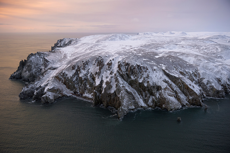
Wrangel Island is one of Russia's most remote reserves, and it was added to the UNESCO World Heritage List in 2004. This once-in-a-lifetime excursion to the "end of creation," as one 19th-century visitor put it, is well deserved: Visitors must first get special permission from the authorities. Second, getting here is difficult – guests arrive by helicopter in the winter and board an icebreaker in the summer.
On both sides of the 180th meridian is an island with a sizeable area. Despite, and in many ways because of, the hard climate, the federally controlled reserve remains a wildlife haven. Wrangel Island features the most polar bear lairs in the world, as well as the largest population of Pacific walruses.
Wrangel Island was also the last refuge of wooly mammoths, according to paleontologists; a dwarf species lived here 6,000 years after the extinction of mammoths in all other regions of the world - mammoth tusks twisted into spirals may still be seen here.
Location: Near Chukchi Sea
Area: 7,600 km²
Max length: 150 km
Source: Exploresweb Source: carl noah -
Big Diomede Island, Russia's farthest eastern point, is only a two-mile swim away in the center of the Bering Strait. Big Diomede Island belongs to Chukotka, according to a Russian Federation order, although there are no local population left, only a Russian border guard base. The locals were largely Eskimos fifty years ago, who afterwards moved to Chukotka's mainland or the American island.
On The Big Diomede Island, one of the region's largest bird sanctuaries, with over 4 million specimens, is found.
Iupiat were the first people to live on the island. "The people of the Diomede and King Islands are Inupiat," according to the First Alaskans Institute.
In 1648, Russian adventurer Semyon Dezhnyov became the first European to reach the islands. In August 16, 1728, Vitus Bering landed on the Diomede Islands, the day the Russian Orthodox Church commemorates the martyr St. Diomede.
Location: Bering Strait
Area: 29 km²
Source: Russia Beyond 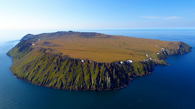
Source: Russia Beyond -
Tourists are drawn to the Solovetsky Islands, or Solovki by its tragic history and haunting, dreadful beauty, not by the northern air on the White Sea.
It was here that the Gulag's first prison was established. As part of Stalin's Great Terror, the Soviet authorities established a network of concentration camps, the first of which was the Solovetsky camp. During WWII, the Solovki government took social orphans and trained them to serve as cadets in the Northern Fleet.
This island in the White Sea has been converted once more, and numerous monks now reside there. It has quickly become one of Russia's most popular tourist destinations, particularly since UNESCO designated the island as a World Heritage Site.
Location: Onega Bay, White Sea
Area: 347 km²
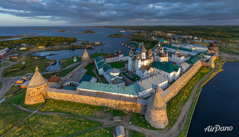
Source: AirPano 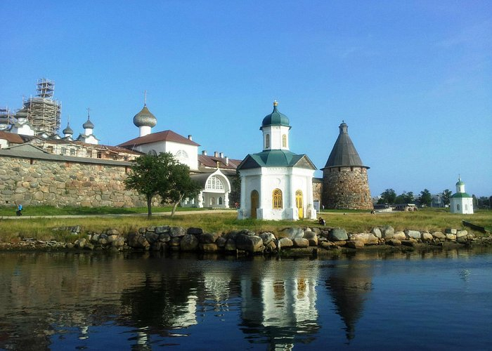
Source: TripAdvisor -
Kizhi is an island in the Republic of Karelia, Russia, at the geometrical center of Lake Onega. It is extended from north to south and is about 6 km long, 1 km wide, and 68 kilometres from Petrozavodsk, Karelia's capital.
The island's settlements and churches have been documented since the 15th century. The population was primarily agricultural, but the government forced them to assist in the construction of ore mining and iron mills in the area, which resulted in the Kizhi Uprising of 1769–1771.
Farming has always been the most important activity of the islanders. Approximately half of the island was converted to farmland; the remaining half was rocky, with the remainder occupied by wetlands. Until 1970, the island contained 96 hectares of grain and potato-producing fields, as well as combine harvesters and tractors for field agriculture. In 2004, as part of the Kizhi museum, certain fields were recreated. Those fields serve as a demonstration of important farming and harvesting processes.
Location: Russia
Area: 5 km²
Source: Getaway 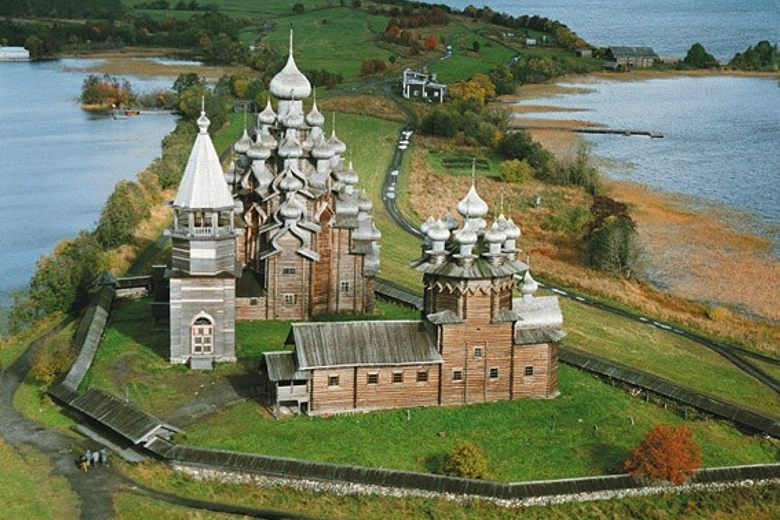
Source: atlas obscura -
From the sea, the Russian island with the French name Moneron reminds one of a scenic landscape from the TV show Lost. It is so little that a half-hour boat ride around it will suffice. Even with the hike to the island's highest point, Staritskiy Mountain, a walk around the island takes roughly 6 hours (440 meters or 1443 feet above sea level). This photographer's paradise, on the other hand, draws those who want adventure and are willing to brave the Tatar Strait's waves.
The environment does not disappoint, with hundreds of unusual birds roaming freely on coastal rocks and indigenous fish, unafraid of humans. Moneron Island grass grows taller than the humans who trek its hills in the summer. The underwater environment of Moneron, however, is its most distinguishing asset; some of the underwater animals found here are found nowhere else in Russia.
Location: Sakhalin, Russia
Max length: 7.15 km
Source: Wikipedia -
Franz Josef Land is a 192-island archipelago. It is one of Russia's and the world's most northern territories, being as close to the North Pole as Northern Greenland. The island is located in the Arkhangelsk region's Primorsky district. Only researchers, border guards, and military air defense personnel who are in charge of the northern ballistic missile defense live there. Polar bear populations in the Russian Arctic are studied by special trips, which collect data on their travel and habitat.
One of the objectives is to figure out how to save the polar bear population, which is rapidly dwindling. The world's most northern post office, "Arkhangelsk 163100," was established here in 2005. Eighty-five percent of the archipelago is glaciated, with substantial unglaciated portions on both the largest and smallest islands. A total of 4,425 kilometers of shoreline connects the islands.
Many wildlife facilities are open during the summer on the archipelago. Seals, walruses, and white whales live here alongside the polar bears.
Location: Arctic Ocean
Area: 16,134 km²
Source: Oceanwide Expeditions Source: Mikronesien05 -
This gorgeous island is located at the confluence of the Volga and Sviyaga Rivers and is readily accessible. Even though a road connects Sviyazhsk to the rural outskirts of Kazan, the capital of Tatarstan, Russia, it is still regarded as an island. The citadel was created as a military bastion in the mid-16th century by none other than Tsar Ivan the Terrible.
The castle was dubbed "conqueror city" because it defeated the Khanate of Kazan, the strongest power of the time. However, by the 17th century, it had lost most of its prominence. In Sviyazhsk, many monasteries were established, and culture, trade, and crafts flourished.
In Sviyazhsk, there is a school and a club, as well as a monastery named after Macarius of Unzha. The railway station of Sviyazhsk is located 6 kilometers west of the island and is connected to Sviyazhsk town by a causeway.
Location: Tatarstan, Russia
Source: Firebird Tours 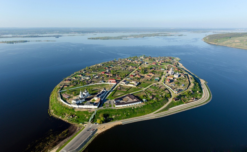
Source: Amazing Planet -
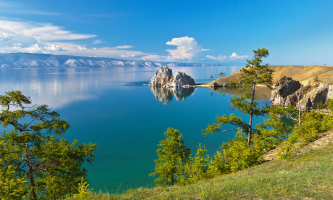
Olkhon is the largest and only populated island in Baikal's magnificent lake. The name of the Olkhon island comes from the Buryat language, which means "dry." The island is surrounded by one-fifth of the world's pure water, which seems paradoxical. However, there are no rivers or even a small creek in this area.
According to the most recent census, Khuzhir is the island's largest community, with roughly 1,350 residents. It is jokingly referred to as the "capital" by those who live there.
Steppe, sandy beaches with dunes and pine trees along the coast, as well as deep woods with larch and spruce in the interior, offer an unsurpassed diversity of scenery. There are also marshes and marble rocks covered in dense red moss. Lake Baikal is a UNESCO World Heritage Site as well.
Location: Lake Baikal
Area: 730 km²
Max length: 114.3 km
Source: Janet Newenham 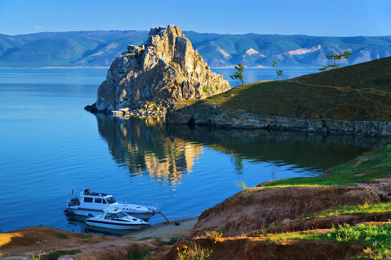
Source: Lonely Planet -
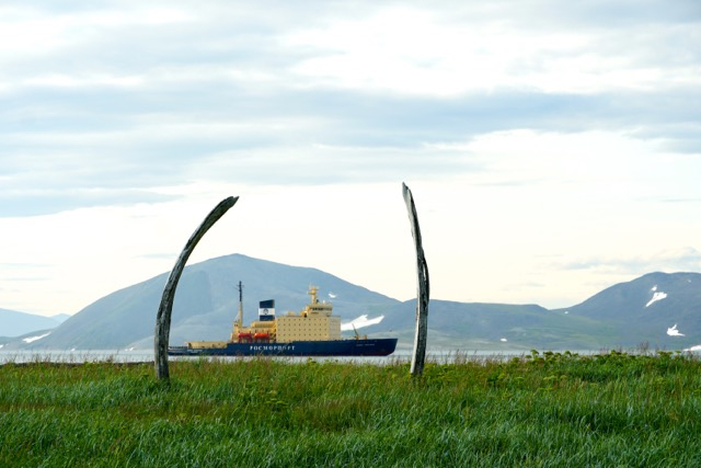
Yttygran is a small hilly island located in the Bering Sea. The famous 'Whale Bone Alley,' a one-of-a-kind memorial to old whaler culture, is located there. This monument is unique to the Chukotka region, if not the entire Arctic region.
Two rows of whalebones, over 1000 feet or 300 meters long, constitute the lane. Whale skulls are grouped into 15 groupings for the row closer to the sea. A row of jawbones can be found if you look higher. They soar 5 meters above the ground when dug vertically. As part of a tour, you can witness the famed "Whale Bone Alley".
Whale bone alley, located on the northern shore of Yttygran island (from the Chukchi Etgyran, "midway homes"), contains a great number of precisely organized whale heads, whale bones, and stones, as well as a significant number of meat storage trenches. Whale Bone Alley is supposed to have served as a focal shrine for a number of settlements dispersed around the eastern Chukotkan coast.
Location: Bering Sea
Area: 55 km²
Source: Heritage Expeditions Source: Let'S TOP TV -
Valaam, an island in Lake Ladoga in Northwestern Russia, is well known for the Valaam Brethren Choir's supernatural abilities and the unique existence of the Orthodox monastery. The beautiful bell tower of the Cathedral of the Transfiguration of the Savior may be seen from afar. Visitors, pilgrimages, and the repair of monasteries and chapels have all come from the religious rebirth of the last two decades. According to academics, the monastery was founded in the 12th century and features engineering marvels such as rocky wells, navigable canals, and drainage systems.
The island has huge rock cliffs and pine forests beyond the monastery. Landscape painters Ivan Shishkin, Arkhip Kuindzhi, Nicholas Roerich (who has a tiny museum on 107th Street in Manhattan), and Tarrytown artist and novelist Rockwell Kent were among many who traveled here for inspiration.
Valaam is the largest island in the archipelago of the same name off the coast of Ladoga Lake. The geology of the island's granite basis generates a unique microclimate that keeps the island almost always warmer than the rest of the world. Take a boat ride on the Ladoga Lake to get to Valaam.
Location: Valaam, Russia
Area: 36 km²
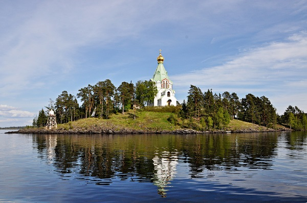
Source: Go-Karelia Tours Source: Oka rus