Top 10 Most Beautiful Waterfalls in Canada

The length and width of Canada are dotted with natural wonders such as mountains, lakes, and waterfalls. Canada, one of the most visited nations on the globe, ... read more...is endowed with several magnificent waterfalls that are just breathtaking. If you're planning a road trip in Canada, waterfalls are great places to stop along the way. They are frequently found right off major roads, and several provincial parks have been established near waterfalls to provide convenient access. With well-marked pathways and picnic spots, they are the ideal scenic destination for any road trip. Here are some of Canada's most magnificent waterfalls.
-
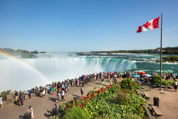
Niagara Falls is a collection of three waterfalls at the southern end of Niagara Gorge that spans the boundary between the Canadian province of Ontario and the American state of New York. Horseshoe Falls, the biggest of the three, crosses the two nations' international boundary. It is sometimes referred to as the Canadian Falls. American Falls and Bridal Veil Falls are both located in the United States. Bridal Veil Falls is located in New York and is separated from Horseshoe Falls by Goat Island and American Falls by Luna Island.
Niagara Falls is both beautiful and an important source of hydroelectric power. Balancing recreational, commercial, and industrial usage has always been a struggle for the falls' caretakers. Between the twin cities of Niagara Falls, Ontario, and Niagara Falls, New York, Niagara Falls is 27 kilometers (17 miles) northwest of Buffalo, New York, and 69 kilometers (43 miles) southeast of Toronto. Water from the newly formed Great Lakes carved a path over and through the Niagara Escarpment en route to the Atlantic Ocean as glaciers receded at the end of the Wisconsin glaciation (the last ice age).
There are other viewing choices available, including the Hornblower boat trip. The Hornblower succeeded the Maid of Mist cruise boat, which was North America's oldest tourist attraction from 1846 until 2013. The base of the falls was utilized to depict "World's End" in the 2007 film Pirates of the Caribbean: At World's End.
Location: Niagara River into the Niagara Gorge; border of New York, United States, and Ontario, Canada
https://www.istockphoto.com/ 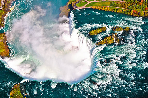
https://www.istockphoto.com/ -
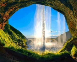
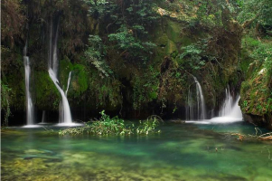
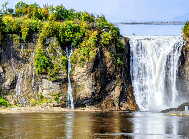
The Montmorency Falls are a huge cascade on Quebec's Montmorency River. These majestic falls, located just outside of Quebec City, are really taller than Niagara Falls. A suspension bridge above the peak of the falls provides panoramic views of the raging river, the St. Lawrence River, and even Île d'Orléans. A funicular transport you from the top to the bottom (or vice versa), but a wooden stairway is available for those who wish to get their daily steps in. The waterfalls are accessible all year, and in the winter, the spray freezes to form a sheet of flowing ice that only the bravest—or most reckless, depending on your point of view—can scale.
Montmorency Falls receives around 970,000 tourists each year. There are staircases that allow tourists to see the falls from various angles. Access to both sides of the park is provided by a suspension bridge that spans the peak of the falls. A funitel transports passengers between the base and the top of the falls. The park conducts an international fireworks competition in the summer, using the falls as a background. Because of the high iron content in the waterbed, the falls glow yellow during the summer months. For its first year, the Ice Hotel was located in Montmorency Falls. The Montmorency Falls tourist attraction will receive a $33 million makeover in July 2019.
Location: Quebec City, Quebec, Canada
https://www.istockphoto.com/ 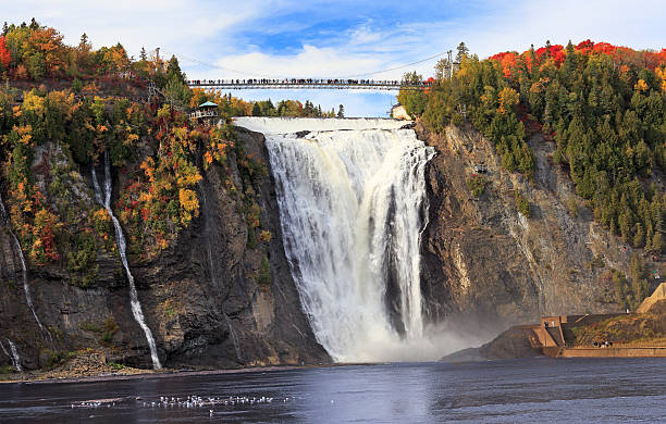
https://www.istockphoto.com/ -
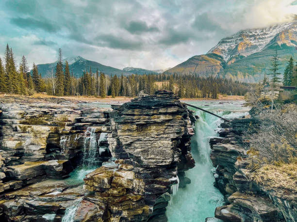
Athabasca Falls is a waterfall in Jasper National Park on the upper Athabasca River, 30 kilometers (19 miles) south of Jasper, Alberta, Canada, and immediately west of the Icefields Parkway. Athabasca Falls is a strong, gorgeous cascade recognized for its force more than its height, due to the massive amount of water cascading into the valley, which may be considerable even on a frigid morning in the fall, when river levels tend to be at their lowest. The river cuts a brief canyon and a number of potholes as it flows over a layer of hard quartzite and into the softer limestone below.
Athabasca Falls is without a doubt one of the most stunning waterfalls in Canada, and it is the crowning achievement of Alberta's famed Jasper National Park. Multiple pathways and bridges cut through rock and open into broad alpine panoramas, allowing for a diversity of viewpoints. You'll travel down the stunning limestone valley before reaching the falls, where rapid flowing water has chiseled away smooth rocks, creating charming tiny cracks and whirling whirlpools. The water's remarkable color fluctuates throughout the year, ranging from milky white to azure blue, yet it is always breathtaking.
The falls may be seen and photographed safely from different observation platforms and walking routes located surrounding the falls. Access is via a neighboring parking area along Highway 93A, immediately northeast of the falls. Highway 93A departs from the neighboring Icefields Parkway and traverses the falls on its route north to Jasper. Whitewater rafting frequently begins below the falls and continues downstream on the Athabasca River to Jasper.
Location: Jasper National Park, Alberta, Canada
https://www.istockphoto.com/ 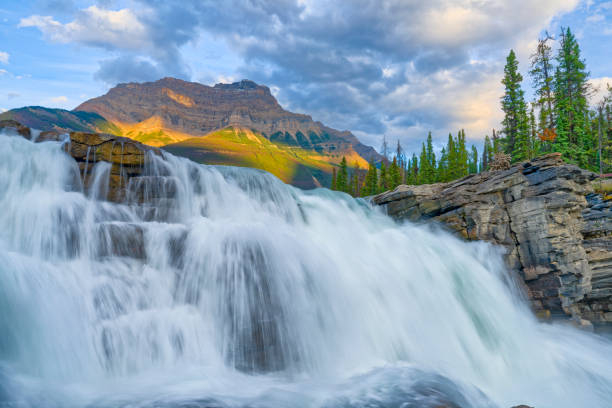
https://www.istockphoto.com/ -
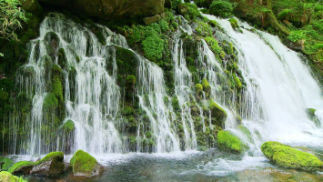
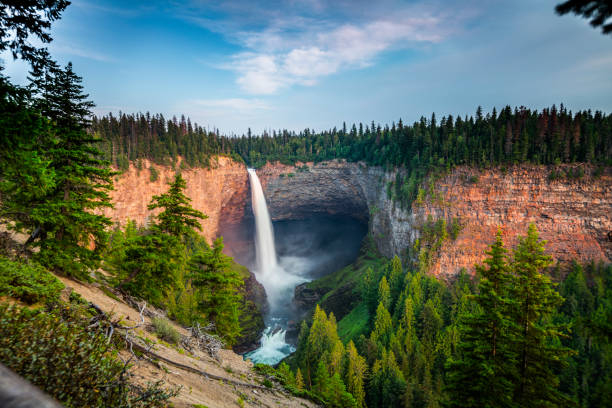
Helmcken Falls is a 141-meter (463-foot) waterfall on the Murtle River in British Columbia, Canada, located inside Wells Gray Provincial Park. One of the objectives for the establishment of Wells Gray Provincial Park in 1939 was to safeguard Helmcken Falls. Helmcken Falls is Canada's fourth tallest waterfall in terms of total straight descent without a pause. Hunlen Falls at Tweedsmuir Provincial Park, Takakkaw Falls in Yoho National Park, and Della Falls in Strathcona Provincial Park, all in British Columbia, have higher Canadian waterfalls.
Upstream from Helmcken Falls, the Murtle River has six more waterfalls. The Mushbowl, Dawson Falls, Majerus Falls, Horseshoe Falls, Meadow Falls, and McDougall Falls are the others. Only Helmcken, The Mushbowl, and Dawson are accessible by road. Trails go to Majerus, Horseshoe, and McDougall Falls. Meadow Falls is difficult to see unless you fly over it. Tumbling water has gradually formed a large canyon at the base of the falls, and frozen spray creates an icy wonderland along the edges in the winter. A platform for getting that perfect shot is easily accessible by road.
Helmcken Falls is most popular with tourists throughout the summer. In exceptionally cold snowy winters, the ice cone at the base typically reaches to 50 m tall, and occasionally much higher. It has been spotted reaching halfway up the falls on occasion. From late January until the end of February is the greatest time to see the ice cone. The cone falls inward sometime in March, with some fragments observable in June. In the winter, the road is plowed and sanded, and volunteers maintain the trails. Snow tires are required, and tire chains are advised as a safety precaution. A network of cross-country ski trails begins near Dawson Falls, but no grooming has occurred since the winter of 2011-2012.
Location: Wells Gray Provincial Park, British Columbia, Canada
https://www.istockphoto.com/ 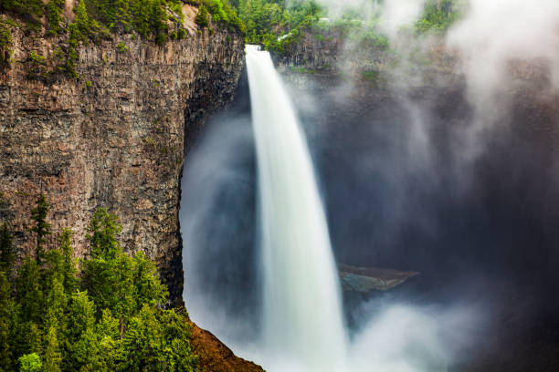
https://www.istockphoto.com/ -
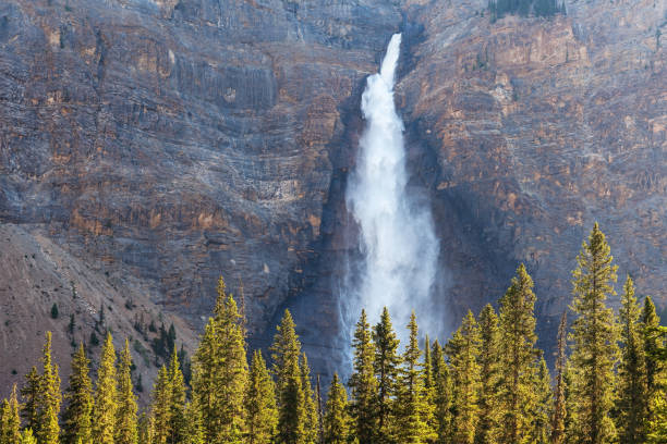
Takakkaw Falls is a waterfall in Yoho National Park in British Columbia, Canada, near Field. The falls are the second highest waterfall in Canada, standing at 373 meters (1,224 feet). The main drop of the waterfall is 254 meters high (833 ft). "Takakkaw" means "magnificent" in Cree. The meltwater from the Daly Glacier, which is part of the Waputik Icefield, feeds the falls. During the warm summer months, the glacier maintains the volume of the falls up, and they are a tourist attraction, especially in late April when the heavy snow melts and the falls are in top condition.
Takakkaw Falls are the second-highest waterfalls in Canada, after Della Falls on Vancouver Island, which should be enough to convince you to visit. Many first-time visitors to the Canadian Rockies overlook Yoho National Park in favor of more popular destinations such as Banff National Park and Jasper National Park. However, because of its easy accessibility by car and a large number of must-see attractions, Yoho National Park is no longer an off-the-beaten-path destination. Takakkaw Falls is also one of the most well-known attractions in the area, so don't expect to have it all to yourself. The falls are very high, and as you get closer, there is a lot of mist and spray. The Takakkaw Falls were also featured in the 1995 film Last of the Dogmen.
Location: Yoho National Park, British Columbia, Canada
https://www.istockphoto.com/ 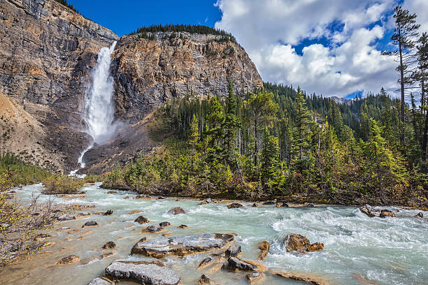
https://www.istockphoto.com/ -
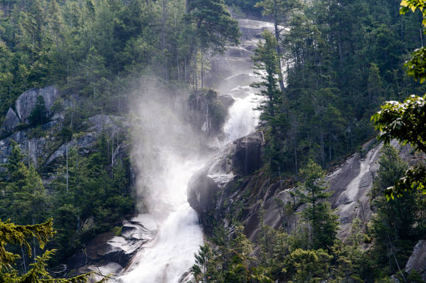
Shannon Falls is located on the Sea to Sky Highway just south of Squamish. A tiny park close to Stawamus Chief Provincial Park, it is home to British Columbia's third tallest waterfall. Because it was so close to the highway, it was also one of the most popular sights. It not only offered two lookouts from which to see the towering falls, but it also had a few "play" sections where visitors could find quiet nooks on Shannon Creek to cool down. There was also a very large bathroom facility as well as a welcome center, indicating the significant frequency of visitors. Shannon Falls has the finest illumination in the afternoon (but this is also when it is most busy). The subsequent crawling movement emptied the water channel into which Shannon Creek plunged. Shannon Falls was formed by a retreating glacier that left both the Howe Sound and a hanging valley high above the U-shaped contour of the Squamish Valley.
If you do wander around the base of the falls, the views of Howe Sound are all time. BC Parks puts quite a lot of time and effort to preserve this little patch of old growth Pacific forest. Please keep on the designated trails. Exploring the creek's boulders and climbing to the base of the falls is dangerous and should only be attempted by experienced hikers and climbers. Please follow the signs and stay on the designated trails. Shannon Falls Provincial Park is located 1km south of Squamish on the east side of Highway 99. The trail starts right outside the picnic area, next to the parking lot.
Location: Provincial Park, British Columbia, Canada
https://www.istockphoto.com/ 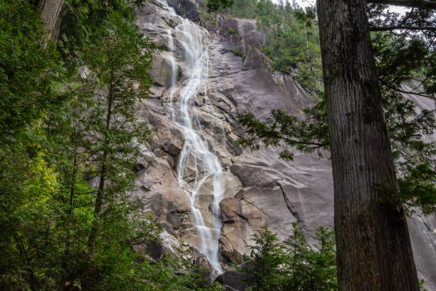
https://www.istockphoto.com/ -
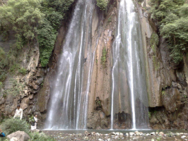
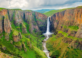
Bridal Veil Falls is a waterfall in Alberta, Canada's Banff National Park. It begins in the Huntington Glacier on the Cirrus Mountain slopes. Its waters flow into Nigel Creek, then into the North Saskatchewan River near the Icefields Parkway's Big Bend. It has a drop of 1,200 feet (370 meters) and a breadth of 20 feet (6.1 m). The falls are accessible by a 15-minute walk through rich flora that includes cedars, hemlocks, and ferns. There are picnic tables accessible, and there are several opportunities to see animals along the way. Mount Cheam, where the falls are located, is also a favorite hang-gliding and paragliding location for those seeking a bird's eye perspective. The Bridal Veil Falls is one of Alberta's most popular attractions.
There are two parking spaces and two access to the falls: one from the steel stairway near to the falls and another a few hundred yards down the path. Highway 540 provides access to both gates. The waterfall and trail system are easily accessible thanks to a modest parking area. During the warmer months, arrive early or find a parking place on the side of the road.
Location: Banff National Park, Alberta, Canada
https://www.istockphoto.com/ 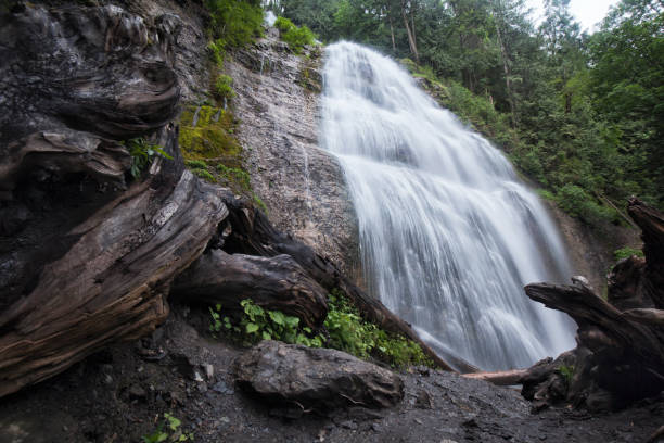
https://www.istockphoto.com/ -
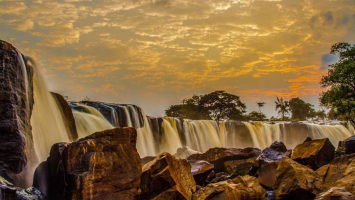
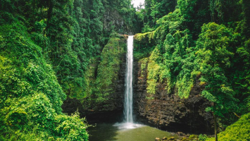
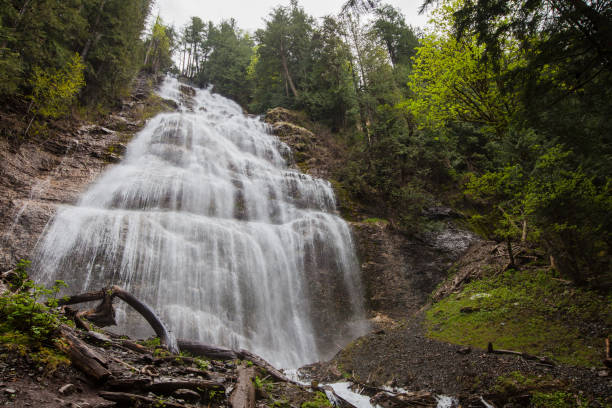
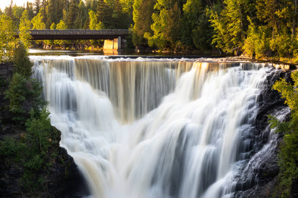
Kakabeka Falls is a waterfall on the Kaministiquia River in the municipality of Oliver Paipoonge, Ontario, 30 kilometers (19 miles) west of the city of Thunder Bay. The falls cascade 40 meters (130 feet) into a valley created out of the Precambrian Shield by meltwater after the last glacial maximum. Because of its magnitude and accessibility of access, it has earned the moniker "the Niagara of the North". The falls' rock wall and the escarpments around the gorge are mostly made of unstable shale and are disintegrating. These rocks support delicate plants and hold some of the oldest fossils on the planet, dating back 1.6 billion years. Along with being home to some of the oldest fossils in the world, the spot is also one of the traditional fur trade routes of the Voyageurs.
Going into the gorge below the falls is not permitted due to the brittle granite. The name "Kakabeka" is derived from the Ojibwe word gakaabikaa, which means "waterfall over a cliff". The National Gallery of Canada owns the most renowned picture of the falls, which was created by Lucius Richard O'Brien in 1882. Frances Anne Hopkins, a well-known historical painter recognized for her depictions of Canadian life, depicted the portage around the falls in 1877. "The Red River Expedition at Kakabeka Falls, Ontario", one of her paintings, depicts the Red River Expedition of 1870 portaging around the falls on its way to the Red River Colony to arrest Louis Riel.
Location: Oliver Paipoonge, Ontario, Canada
https://www.istockphoto.com/ 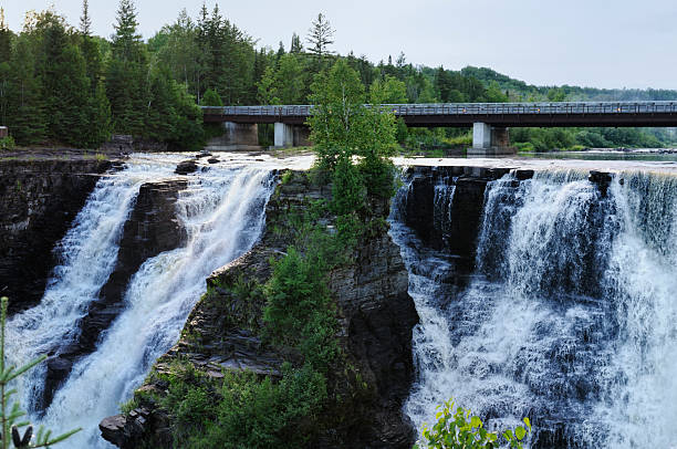
https://www.istockphoto.com/ -
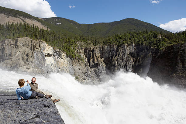
Virginia Falls is located on the South Nahanni River in Nahanni National Park Reserve in the Northwest Territories. It is located 75 miles from the Yukon border at a height of 1,600 feet. The Virginia Falls Water Aerodrome, the closest access point, is only 1,300 feet upstream. Snail fossils discovered in the park date back over 300 million years. The Dené people, an indigenous First Nations group, first settled in this area around 8,000-10,000 years ago. In the 18th century, Europeans began to use the area for fur trading after hearing stories about Nálcho, or "big water falling", as described by the Dené people. Its existence was not established until 1928, when Fenley Hunter spent 56 days attempting to reach it. Virginia Falls was named after Hunter's daughter.
Pierre Trudeau visited the region in 1972 and designated it as a National Park. It was one of four parks designated as UNESCO World Heritage sites in 1978, owing primarily to Virginia Falls. An agreement between the Dehcho First Nations and Parks Canada enables for the park and Virginia Falls to be managed collaboratively. The Fort Simpson visitor center preserves the area's aboriginal history and culture, and tourists who go to the falls' perspective will participate in a Dené ceremony. Mason's Boulder, a massive rock in the midst of the falls, is named after Bill Mason, a notable Canadian environmentalist and photographer. After Mason's death, a park warden began referring to it as such, and the name stuck.
Virginia Falls is best visited between June and August due to the severe temperature, floods, and unpredictable weather. Even if you are traveling in the summer, dress warmly if you intend to explore the waterfall's base. The waterfall's mist and wind cause the temperature to drop 10-15°C below the air temperature. The park itself is enormously large and diverse, and it now covers 11,602 square miles of wilderness after being expanded in 2009. It's no surprise that visitors spend up to a month exploring the park because there's so much to see and do.
Location: Nahanni National Park Reserve, Northwest Territories, Canada
https://www.istockphoto.com/ 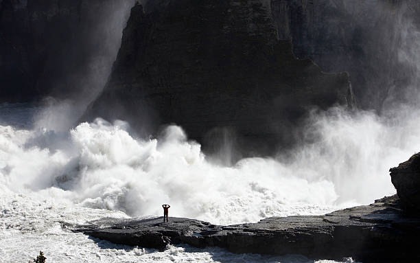
https://www.istockphoto.com/ -
Della Falls is a waterfall on Vancouver Island in British Columbia, Canada, situated inside Strathcona Provincial Park. It is the 16th tallest verified waterfall in Canada and the second tallest on Vancouver Island, behind Kiwi Falls in Schoen Lake Provincial Park, with a total height of 440 m (1,440 ft). Joe Drinkwater, a prospector and trapper, discovered* Della Falls in 1899 and named them after his wife. Near the falls, there is still evidence of his gold mine enterprise, including an aerial tramway he erected. Discovered in the setting of Europe. Long before Drinkwater walked there, First Nations Peoples were aware of the falls.
Other than via helicopter, the only means to get to Della Falls is to traverse the whole Great Central Lake by boat; the only road access to the lake is on the opposite side from Strathcona Park. Following the 35-kilometer (21-mile) crossing, there is a dock that marks the beginning of Strathcona Park, as well as a camping area that can be used as a base camp before attempting the next 15-kilometer (9-mile) ascent to the base of Della Falls. There are more campsites along the trail and near the base of the falls. The hike, which follows an old logging railway for part of the way, takes about seven hours one way and is suitable for intermediate hikers.
Location: Strathcona Provincial Park, British Columbia, Canada
AllTrails 
touristlink.com