Top 10 Longest Rivers In Czech Republic

If you want to cycle around the bank of a beautiful river, or simply take a stroll near the water's edge, or if you want to go on a boat ride or participate in ... read more...water tourism, there are some famous rivers in Czech Republic that you should visit. Here is a list of ten major rivers in the Czech Republic that will satisfy your wanderlust. Check out the list and prepare to be wowed by some breathtaking scenery the next time you visit the Czech Republic.
-
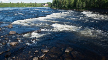
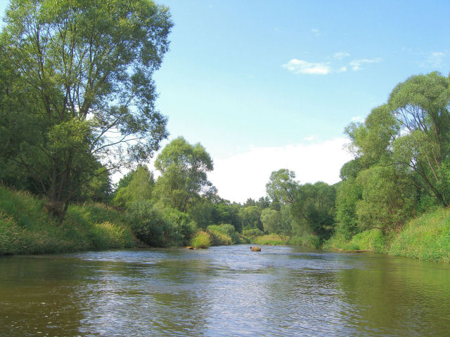
The Elbe River, also known as the 'Label' in the Czech Republic, is one of the country's most popular rivers. It flows for approximately 678 miles from the Krkonose Mountain range to the North Sea in Germany.
During the Middle Ages, this river served as a trade route between the Charlemagne Empire and the Holy Roman Empire. In later centuries, the river also served as a connecting trading link to Prague. The river is home to many wetlands, as well as many woodland habitats, and it sustains the wine-producing areas of the Bohemian region. The source Elbe, the very beautiful Krkonose mountain range, will soothe your senses with views of ridges, meadows, and thermal springs. A stone wall with coats of arms from towns in the Bohemian region can also be found on the site, which runs along the banks of the Elbe. As you stroll along the banks of the Elbe, take in the beautiful scenery and absorb the history of the medieval period.Location: Krkonose Mountains, Northern Czech Republic
Length: 1,112 km (691 mi)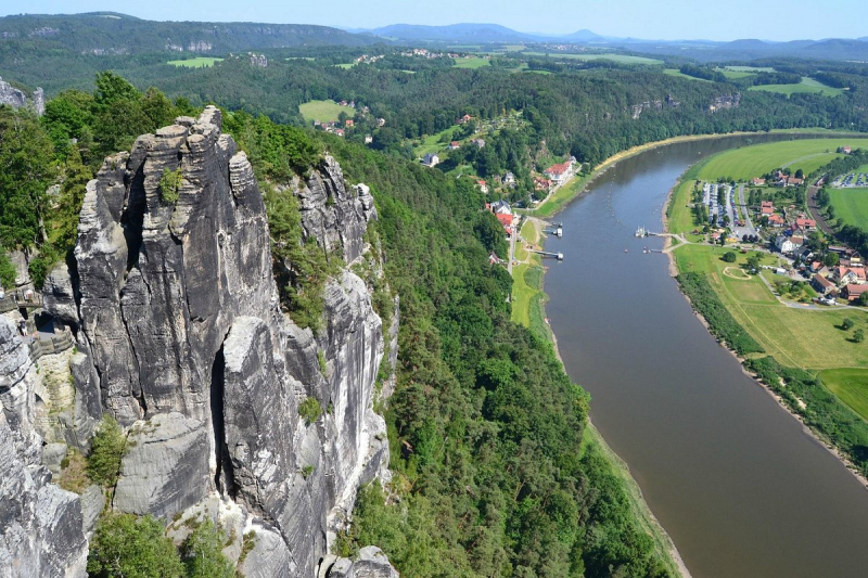
tripadvisor.com.vn 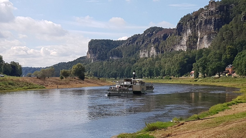
tripadvisor.com.vn -
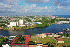
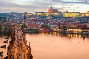
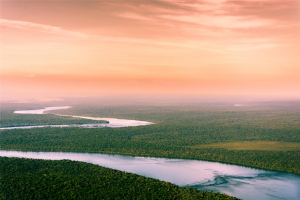
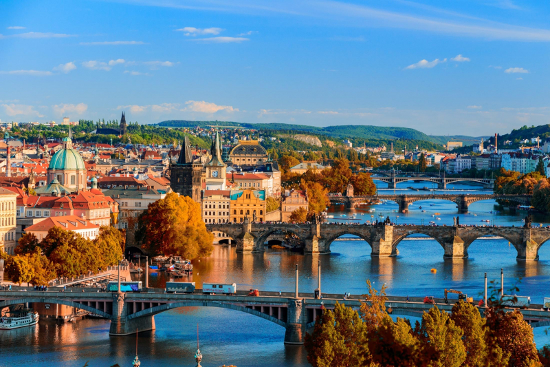
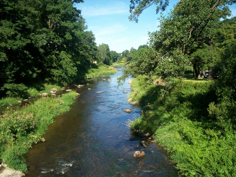
The Vltava river is 430 kilometers (267.4 miles) long and drains an area of 28,090 square kilometers (10,850 square miles), which is more than half of Bohemia and roughly one-third of the Czech Republic. The river runs through Prague, crossing 18 bridges (including the Charles Bridge) and covering 31 kilometers (19 mi) within the city. The river's water was used for drinking until 1912 when the Vinohrady Water Tower stopped pumping. It is, however, the source of drinking water in the event that the water supply from the elivka and Kárané sources fails or needs to be repaired. The Podol water treatment plant is ready for such situations, with a long section of the river upstream of the Podol plant subject to stricter, second-degree pollution prevention regulations.
The elevation difference between the source and the mouth is approximately 1,016 meters (3,333 feet), and the largest stream at the source is known as ern Potok (Black Brook) or Teplá Vltava (Warm Vltava). The Vltava is formed by the confluence of two streams, the Warm Vltava (Teplá Vltava), which is the longer of the two, and the Cold Vltava (Studená Vltava), which originates in Bavaria. Vltava receives numerous tributaries along its course, the most significant of which are Otava and Berounka on the left and Lunice and Sázava on the right.Location: Along south eastern Bohemian forest
Length: 430 km (270 mi)
wikipedia.org 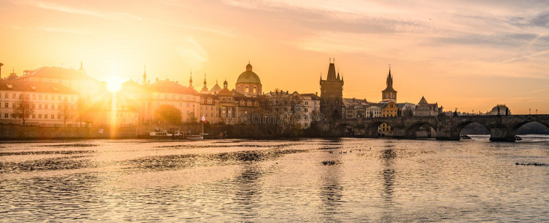
dreamstime.com -
The Oder River is 840 kilometers (522 miles) long: 112 kilometers (70 miles) in the Czech Republic, 726 kilometers (451 miles) in Poland (including 187 kilometers (116 miles) on the border between Germany and Poland) and is the third-longest river in Poland (after the Vistula and Warta), but the second-longest river overall when its total length, including parts in neighboring countries, is taken into account. It drains a basin of 119,074 square kilometers (45,975 square miles), of which 106,043 km2 (40,943 sq mi) are in Poland (89 percent), 7,246 km2 (2,798 sq mi) are in the Czech Republic (6 percent), and 5,587 km2 (2,157 sq mi) are in Germany (5 percent ). Channels connect it to the Havel, Spree, Vistula, and Konica systems. It runs through the Polish voivodeships of Silesian, Opole, Lower Silesian, Lubusz, and West Pomeranian, as well as the German states of Brandenburg and Mecklenburg-Vorpommern.
The main branch empties into the Szczecin Lagoon, which is located near Police, Poland. The islands of Usedom (west) and Wolin (north) border the Szczecin Lagoon (east). There is only a narrow channel (wina) connecting these two islands to the Bay of Pomerania, which is part of the Baltic Sea.
Wrocaw, in Lower Silesia, is the Oder's largest city.Location: Olomouc district, Czech Republic.
Length: 840 km (520 mi)
wikipedia.org 
wikipedia.org -
The Bóbr River is 279 kilometers (173 miles) long (3 in Czech Republic, 276 in Poland, 10th longest Polish river) and has a basin area of 5,874 square kilometers (2,268 square miles) (44 in Czech Republic and 5,830 in Poland). Its origins can be traced back to a slope of the Rchory mountains in the southeast of the Krkonoe range. The source is near the small village of Bobr in the municipality of Aclé in the Czech Republic's Hradec Králové Region. It flows north from the Bohemian region into adjacent Silesia, parallel to the Oder's Lusatian Neisse tributary in the west.
The river flows northwest through the Jelenia Góra valley of the Western Sudetes to the dam of Pilchowice and downhill into the plains of Lower Silesia, passing through the towns of Jelenia Góra, Bolesawiec, Szprotawa, and aga, where the parallel Kwisa river joins it. The river eventually empties into the Oder near Krosno. It is a popular canoeing destination due to its inability to be navigated for its entire length.
Location: Northern Part of Czech Republic.
Length: 279 km (173 mi)
wikipedia.org 
wikipedia.org -
The Ohre is a river in northern Germany that is a tributary of the Elbe. It is 104 kilometers long in total (65.2 mi). Its source is in Lower Saxony, north of Wolfsburg. It flows generally south-east, initially paralleling the border between Lower Saxony and Saxony-Anhalt. It flows entirely through Saxony-Anhalt after Buchhorst, along the Mittellandkanal. It empties into the Elbe near Rogätz, just north of Magdeburg. Along the river are the towns of Brome, Calvörde, Haldensleben, and Wolmirstedt. The upper Ohre course is located in the Drömling nature reserve. Between the end of WWII and German reunification, the Ohre separated East and West Germany, forming part of the Inner German border.
There are many marked tourist routes along the river banks that you can stroll through. This educational trail includes 12 stops that provide geological, archeological, and botanical information. Throughout your journey, you will come across numerous remnants of the area's oldest Slavic settlement. Although the most noticeable feature of your tour will be the granite rock town, which is formed by rock towers with distinctive block jointing.
Location: Loket, Czech Republic.
Length: 104.9 km (65.2 mi)
wikipedia.org -
With a length of about 400 kilometers (250 miles), the Spree River is the main tributary of the Havel River. The Spree is significantly longer than the Havel, into which it flows at Berlin-Spandau; the Havel then flows into the Elbe at Havelberg. The river begins in the Lusatian Highlands, which are part of the Sudetes, in the Lusatian part of Saxony, where it has three sources: the historical Spreeborn in Spreedorf, the water-richest one in Neugersdorf, and the highest elevated one in Eibau. The Spree then flows north through Upper and Lower Lusatia, where it crosses the Saxony-Brandenburg border. It forms the Spree Forest, a large inland delta and biosphere reserve, after passing through Cottbus. It then flows as Müggelspree through Lake Schwielochsee before entering Berlin.
The Spree is the main river of Berlin, Brandenburg, Lusatia, and the Sorb settlement area, which they call Sprjewja. The Spree, as Spréva, forms the border between Germany (Saxony) and the Czech Republic for a very short distance close to its sources (Bohemia). Dahme (confluence in Berlin-Köpenick) and Schwarzer Schöps (confluence in Sprey) are the Spree's longest tributaries; other well-known tributaries (because they are Berlin rivers) are Panke and Wuhle.Location: Czech Republic-Germany
Length: 400 km (250 mi)
wikipedia.org -
The Lusatian Neisse, also known as the Western Neisse (German: Lausitzer Neiße; Polish: Nysa uycka; Czech: Luická Nisa; Upper Sorbian: uiska Nysa; Lower Sorbian: uyska Nysa), is a 252-kilometer (157-mile) river in northern Central Europe. It rises in the Jizera Mountains near Nová Ves nad Nisou on the Czech border, then crosses the Polish–German border for the final 197 kilometers (122 miles) to join the similarly northward-flowing Oder.
Its drainage basin spans 4,403 km2 (1,700 sq mi), with 2,201 km2 (850 sq mi) in Poland and the remainder primarily in Germany. After leaving the Czech Republic, the river reaches the tripoint of the three nations at Zittau, a German town/city. It is a left-bank tributary of the Oder, flowing between Neißemünde-Ratzdorf and Kosarzyn – north of Guben and Gubin.
The river has partially demarcated the German-Polish border since the 1945 Potsdam Agreement in the aftermath of World War II (along the Oder-Neisse line).
It is the longest and most populous of the three rivers with the same non-adjectival name in both languages (the other two rivers are the Eastern Neisse (German: Glatzer Neisse) and the Raging Neisse (Polish: Nysa Szalona; German: Wütende Neiße or Jauersche Neiße). It is commonly referred to as the Neisse.Location: Czech Republic - Poland - Germany
Length: 252 km (157 mi)
wikipedia.org -
The White Elster (German: Weiße Elster, Czech: Bl Haltrov) is a 257-kilometer (160-mile) long river in central Europe that is a right tributary of the Saale. Its source is in the westernmost part of the Czech Republic, near A. After a few kilometres, it flows into eastern Germany, where it cuts through the Vogtland in a "deep and picturesque valley," according to the Encyclopaedia Britannica. It flows through the German states of Saxony, Thuringia, and Saxony-Anhalt. The White Elster flows through Plauen, Greiz, Gera, Zeitz, Pegau, and Leipzig before joining the Saale in Halle.
Although the word "Elster" is German for "magpie," it has nothing to do with the bird. It derives from the Slavic word alstrawa, which means "hurrying water." The White Elster never meets the Black Elster, which flows into the Elbe from Lusatia. To identify them, the rivers are labeled "white" and "black."Visitors to the river banks can enjoy a breathtaking view of the White Elster. Along your river tour, you will come across numerous centuries-old structures that are truly breathtaking. You can also take motorboat tours down the river if you want.
Location: Location: South Western part of Czech Republic.
Length: 257 km (160 mi)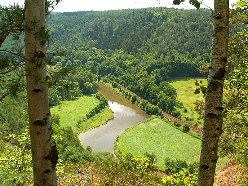
wikipedia.org 
dreamstime.com -
The Morava River (March in German, Morva in Hungarian, Morawa in Polish) is a river in Central Europe and a left tributary of the Danube. It is the primary river of Moravia, which bears its name. The river flows southward from the Králick Snnk mountain in the north-eastern portion of Pardubice Region, near the boundary between the Czech Republic and Poland. The river's lower course marks the border between the Czech Republic and Slovakia, then Austria and Slovakia.
The lower part of the river, downstream of the confluence with the Thaya at Hohenau a der March, which today marks the Austro-Slovakian border, is one of the oldest national boundaries still in existence in continental Europe: it was the eastern boundary of the Carolingian Empire with the Avar Khaganate around 800, and from the 10th century marked the border of the Imperial marcha orientalis, later Duchy of Austria, with the Kingdom of Hungary (within the Habsburg monastery This segment of the river was part of the Iron Curtain during the Cold War, constituting the border between Austria and Czechoslovakia.
The Morava's coasts have been inhabited for a very long period. Stillfried, on the Austrian side of the river, was the site of a human settlement as early as 30,000 years ago. Agriculture first appeared in the Morava valley some 7,000 years ago, and fortified communities appeared during the New Stone Age.
Location: Near the borders between Czech Republic and Poland.
Length: 352 km (219 mi)
wikipedia.org -
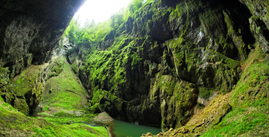
The Thaya River (Czech: Dyje) is the longest tributary of the Morava river in Central Europe. It has a drainage basin of 12,772 km2 (4,931 sq mi). It is 224 kilometers (139 miles) long (322 kilometers (200 miles) with its longest source river, the German Thaya) and meanders from west to east in the border area between Lower Austria (Austria) and South Moravia (Czech Republic), though the border does not exactly follow the river's course in most places. It is fed by two smaller rivers, the German Thaya (Deutsche Thaya) and the Moravian Thaya (Czech: Moravská Dyje, German: Mährische Thaya), which combine at Raabs.
On the Czech side of the river, the Narodni Park Podyji is rich with stone boulders and lakes with a unique geomorphology. This area is home to a wide range of plants and animals. It is one of the most untouched and well-preserved river valleys in the Czech Republic. If you want to relax in the midst of nature, here is the place to be.
Location: Czech Republic
Length: 223.9 km (139.1 mi)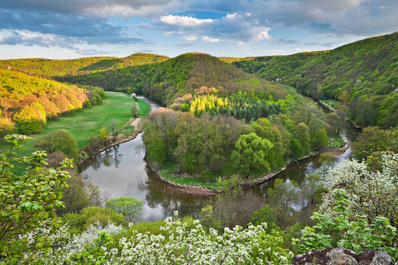
lookphotos.com