


Top 10 Longest Rivers in Norway

Norway, officially known as the Kingdom of Norway, is a Nordic country in Europe's northwestern region. The country also includes parts of the Scandinavian ... read more...Peninsula, the Svalbard archipelago, and the island of Jan Mayen. The country covers an area of approximately 148,728 square miles, with some of this area covered by water. Water from bodies such as rivers and lakes makes up 5.2 percent of this area. These bodies of water are important for hydropower generation, transportation, aquatic habitat, and domestic use. Toplist has compiled the longest rivers in Norway.
-
The Glomma, or Glåma, is Norway's longest and largest river. With a total length of 621 kilometers (386 miles), it has a drainage basin that covers fully 13% of Norway's surface area, all of which is located in the country's south.
At its longest, the river flows from Lake Aursund near Røros in Trøndelag to the Oslofjord at Fredrikstad. The Vorma River, which drains Lake Mjøsa and joins the Glomma River at Årnes in Nes, is a major tributary. The Lågen drains into Lake Mjøsa, collecting drainage from the large Gudbrandsdalen and increasing the flow of the Glomma significantly.
Because it flows through some of Norway's richest forest districts, it has long been the country's leading log-floating river. The combination of raw materials, water power, and easy transportation has encouraged industry along the Glomma for centuries. Some of the country's largest manufacturing and processing concerns are concentrated near the river's mouth, where abundant supplies of timber and hydropower are complemented by excellent port facilities.
The upper limit of the Glomma valley farms varies, but it is usually around 500 metres (1,600 ft) in Østerdalen, which is slightly lower than in Gudbrandsdalen due to the colder climate. In Østerdalen, the treeline rises to about 900 meters (3,000 feet) with a light birch forest. The forest is restricted to the valley floor above Røros.
Norwegian river upper valleys have distinct names that are remnants of earlier cultural distinctions such as building styles, traditional clothing or bunad, and domestic crafts. The Østerdal is the upper valley of the Glomma (or East Valley).
The Glomma has formed Europe's largest inland delta upon entering Lake Øyeren at Fetsund, reaching the opposite side of the lake across its short axis. Some of the massive amount of silt deposited by the Glomma in Lake Øyeren is extracted to make LECA building blocks, which are widely used in the construction of foundations in Norway.
Length: 621 km (386 mi)
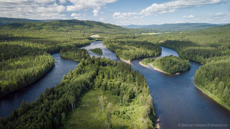
Photo: Fishspot 
Photo: Wikipedia -
Klarälven is a river that runs through both Norway and Sweden. Together with Göta älv, so named because the river flows through Lake Vänern and is thus considered an entity, Göta älv—Klarälven is the longest river in Scandinavia and the Nordic countries, and its Swedish section is the longest river in Sweden. These two rivers also have the largest drainage basins in the same areas, totaling 50,229 km2 (19,394 sq mi) when all rivers that flow into Vänern are included, 42,468 km2 (16,397 sq mi) in Sweden and 7,761 km2 (2,997 sq mi) in Norway.
It originates on the northeast side of Mount Brändstöten and flows through a couple of smaller lakes down to Lake Rogen in Härjedalen, Sweden, before entering the Norwegian Hedmark and flowing through Lake Femunden. It is known as Femundelva and Trysilelva there. The rest of the river, the longest section, flows through Värmland before emptying into Vänern in a delta at Karlstad.
Vänern, in turn, drains into Göta älv before reaching the sea at Gothenburg. The river has historically provided significant economic benefits by serving as a suitable transport route for log driving, and it is now internationally recognized as having excellent sport fishing waters.
Length: 460 km (290 mi)
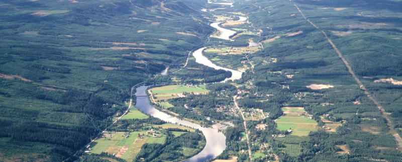
Photo: Interreg North Sea Region 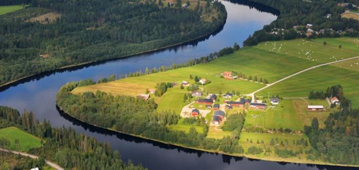
Photo: Daily Scandinavian -
The Tana is a 361-kilometer (224-mile) long river in northern Fennoscandia's Sápmi region. The river flows through Norway's Troms og Finnmark county and Finland's Lapland region. The Sámi name translates to "Great River." Tana's main tributaries are Anarjohka and Karasjohka.
It runs for 256 kilometers (159 miles) along the Finnish–Norwegian border, between the municipalities of Utsjoki in Finland and Karasjok and Tana in Norway. The river is Norway's fifth-longest. The river flows through the Norwegian municipality of Tana for the last 105 kilometers (65 miles). The river empties into the Tanafjorden, one of Europe's largest and most pristine river deltas. The delta is protected and serves as an important habitat for wetland birds. The delta contains large sand deposits that are exposed sandbars at low tide.
Authorities in Norway and Finland have decided not to allow salmon fishing in 2021. (in the river). The Tana River is well known for its excellent salmon fishing and is the most productive salmon river in both Finland and Norway. A salmon caught on the Tana holds the world record for Atlantic salmon; it weighed 36 kilograms (79 pound) and was caught in 1929 by the late Nils Mathis Walle.
Length: 361 km (224 mi)
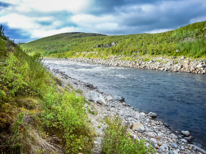
Photo: Wikipedia 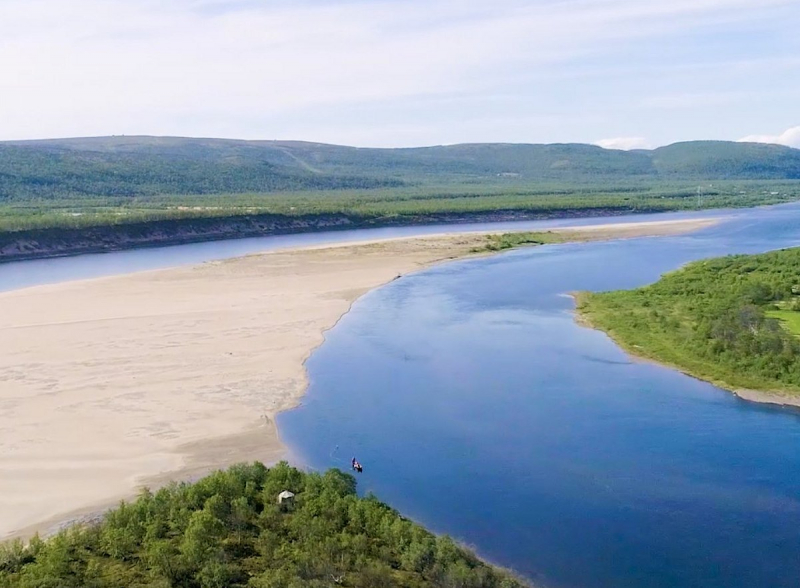
Photo: TripAdvisor -
The Drammenselva (English: Drammen River) is a river in the county of Buskerud in southeastern Norway.
Drammenselva is one of Norway's largest rivers, with a drainage basin of approximately 17,000 square kilometers (6,600 square miles) and a discharge of 300 cubic metres per second (11,000 cu ft/s) per second. The Drammen River is the fifth longest river in Norway, with a total length of 308 kilometers (191 miles).
Its 48-kilometer course runs from Tyrifjorden in the north to Drammensfjord in the south, where it cuts through the city center. The Drammen River receives inflow from a number of streams and rivers. The Simoa River is one of the largest. The entire drainage system, including the Drammenselva, is known as Drammensvassdraget and is located in the provinces of Oppland and Buskerud.
For centuries, the river was used for log driving, transporting timber from Eiker's forests to the many paper mills and other industries that dotted the river's banks. Many steam-powered sawmills and planing mills were established along the lower section of the river beginning in the 1850s, and products became exports passing through the Port of Drammen. This activity polluted the river heavily during the twentieth century. However, the majority of Drammen's paper and pulp mills closed in the 1960s and 1970s, and the river is now clean and safe.
Length: 308 km (191 mi)
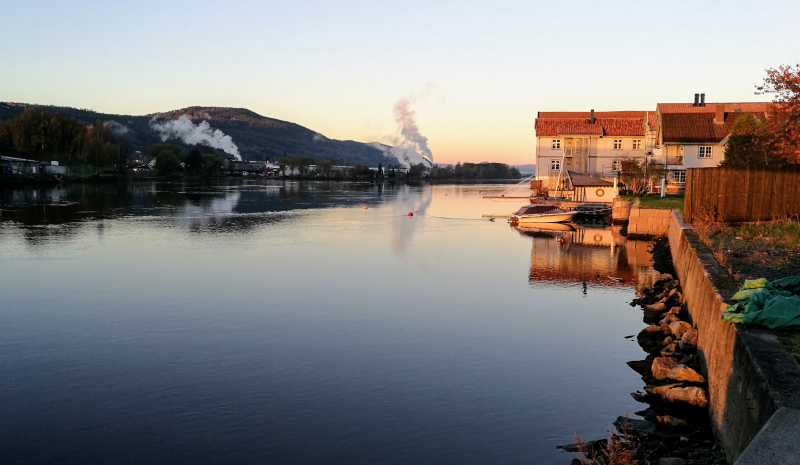
Photo: Wikipedia 
Photo: Wikimedia Commons -
The Trysilelva is part of the Trysilvassdraget, which has the large lake Femunden as its center, in the border areas between the Inland and Trøndelag. The river starts as the Femund River which flows out of Galtsjøen south of Femunden. Galtsjøen has its supply from Femunden and Isteren via Isterfossen, Galthåen and Galtstrømmen. Femundselva flows through Engerdal until it reaches Sennsjøen (520 masl). From there, the river is called Trysilelva where it flows down through Trysil's forested landscape. South of Nybergsund, the name Klara is also used on the river. Near the border with Sweden, there are two power plants on the Norwegian side: Sagnfossen and Lutufallet. Further from there, the Trysilelva river flows into Sweden with the name Klarälven by Långflon. In Sweden, the river flows into Sweden's largest lake Vänern near the city of Karlstad.
The Trysilelva is part of what is seen in context as Scandinavia's longest watercourse, including the lakes along the way, and which changes its name several times. The source of this river is Lake Rogen on the border between Norway and Härjedalen. Here the river is called Røa, and follows the border between Røros in Trøndelag and Engerdal in the Inland all the way to Femunden. From Femunden it flows under the name Femundselva through Engerdal municipality. When the river reaches Trysil municipality, it is called Trysilelva up to the Swedish border and from there is called Klarälven all the way down to Vänern. Lake Vänern's outlet is through the Göta River, which flows into the Kattegat near Gothenburg.
The Trysilelva is permanently protected against power development in accordance with Conservation Plan I for watercourses. The river had major floods in 1927, 1934 and 1967. On June 1, 1995, all these flood targets were passed under what is known as Vesleofsen. The river then had a water flow of 760 m³ / s at Nybergsund. Storofsen still holds the flood record.
Length: 256.7 km (160 mi)
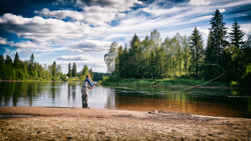
Photo: Fishspot 
Photo: NAF Camp -
Numedalslågen is a river in southeastern Norway that flows through the counties of Vestfold, Telemark, and Viken. It is one of Norway's longest rivers.
Numedalslågen runs for over 250 kilometers (160 miles) through the counties of Vestfold, Telemark, and Viken, beginning on the Hardangervidda plateau and ending at Larvik in Vestfold. Numedalslågen is one of the longest rivers in Norway. The river flows through Larvik, Lardal, Kongsberg, Flesberg, Rollag, and Nore og Uvdal. These municipalities work together in the administration and use of river resources in various projects under the Green Valley (Grønn Dal) umbrella.
In the higher range of Numedalslågen, there are a number of hydroelectric plants. Except for the stretch between Hvittingfoss and Larvik and Godfarfossen in Dagali, the majority of the main river's power potential has been developed.
The first power plant built in the Nore municipality in Viken, Nore I kraftverk, used Norefallene between Tunhovdfjorden and Rødberg. It was designed by Norwegian architects Carl Buch and Lorentz Harboe Ree and completed in 1928. The Nore II kraftverk, which was completed in 1947, uses the drop between Rødberg dam and Norefjord.
Numedalslågen is well-known for its salmon fishing, but a parasite known as Gyrodactylus salaris has recently been discovered in the area, potentially endangering the salmon stock. Other fish species found in Numedalslågen include trout, eel, and pike.
Length: 250 km (160 mi)
Photo: Wikimedia Commons 
Photo: Wikimedia Commons -
The Otra is the largest river in Norway's Sørlandet region. It starts in the Setesdalsheiene mountains, near Lake Breidvatnet in Bykle municipality in Agder county, just south of the border with Vinje municipality in Vestfold og Telemark county. The river then flows south through the municipalities of Bykle, Valle, Bygland, Evje og Hornnes, Iveland, Vennesla, and Kristiansand. The river empties into the Skagerrak in the center of Kristiansand on Norway's southern coast.
The Otra is Norway's eighth-longest river, measuring 245 kilometers (152 miles). Åraksfjorden, Byglandsfjorden, Hartevatnet, and Kilefjorden are just a few of the large lakes along the river. Along the river, 12 hydroelectric power plants have been built, producing a large portion of Norway's electricity.
Because the water in the Otra River is not too acidic, salmon thrive there. The calcareous rocks in the catchment area at the northern end of the Setesdal valley provide a buffer capacity for the water against acidification.
Length: 245 km (152 mi)
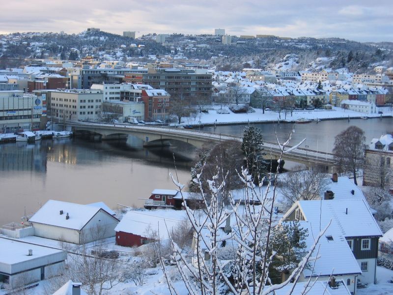
Photo: Wikipedia 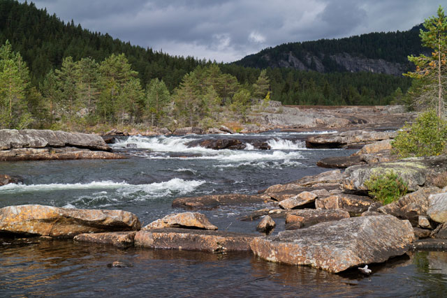
Photo: Freshwater information - Tools -
Altaelva is the third-longest river in Norway's Troms og Finnmark county. The river starts in the mountains and lakes of Kautokeino Municipality, close to the border with Troms og Finnmark county and Finland, just south of Reisa National Park.
The 240-kilometer-long river then flows north into Alta Municipality, where it empties into the Altafjorden in the town of Alta. On its way from the high Finnmarksvidda plateau to the sea, the river carved out Sautso, one of Europe's largest canyons. Along the river are the villages of Kautokeino and Masi, as well as the town of Alta.
The river was the site of the Alta controversy concerning the construction of a hydroelectric power plant in the 1970s and 1980s. The Alta power station was eventually built in 1987, creating the river's lake Virdnejávri.
The river is one of Norway's best salmon rivers, known for its large-sized salmon. Salmon weighing up to 33 kilograms (73 lb) were caught in the past, and fish weighing up to 24 kilograms (53 lb) are still caught today. On the river in 2011, 1,082 salmon (7 kilograms (15 pound) or larger) were caught.
Length: 240 km (150 mi)
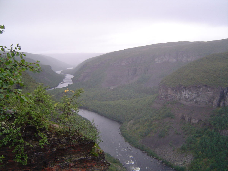
Photo: Wikipedia 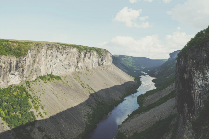
Photo: Grieg Seafood -
Namsen (Norwegian) or Nååmesje (Southern Sami) is one of Norway's longest rivers, located in Trøndelag county in the country's central region. Before emptying into the Namsenfjorden, the 228-kilometer-long river flows through the municipalities of Røyrvik, Namsskogan, Grong, Overhalla, and Namsos. The Namdalen region is named after the river. Traditionally, the river was used to transport timber from the forests to the town of Namsos, where the sawmills were located. Several dams now regulate parts of the Namsen.
The river starts in the springs of Børgefjell National Park, just across the border in Nordland county. This water is used to irrigate the large lake Store Namsvatnet. The Namsen river begins when water flows through the dam on the northwest side of Lake Namsvatnet in the municipality of Røyrvik.
The river then flows through the Namdalen valley towards the coast, ending at Namsos where it flows into the Namsenfjorden, which also contains the smaller river Årgårdselva. The Namsen has two major tributaries: Tunnsjøelva and Sanddøla.
The total watershed area is approximately 6,298 square kilometers (2,432 square miles), and the water discharges into the fjord at Namsos at approximately 285 cubic metres per second (10,100 cu ft/s).
Length: 228 km (142 mi)
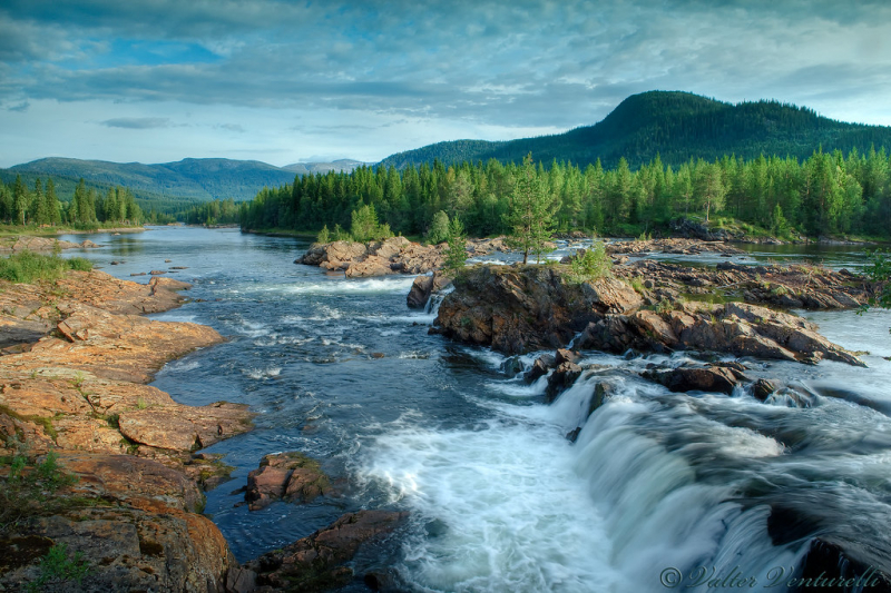
Photo: Flickr 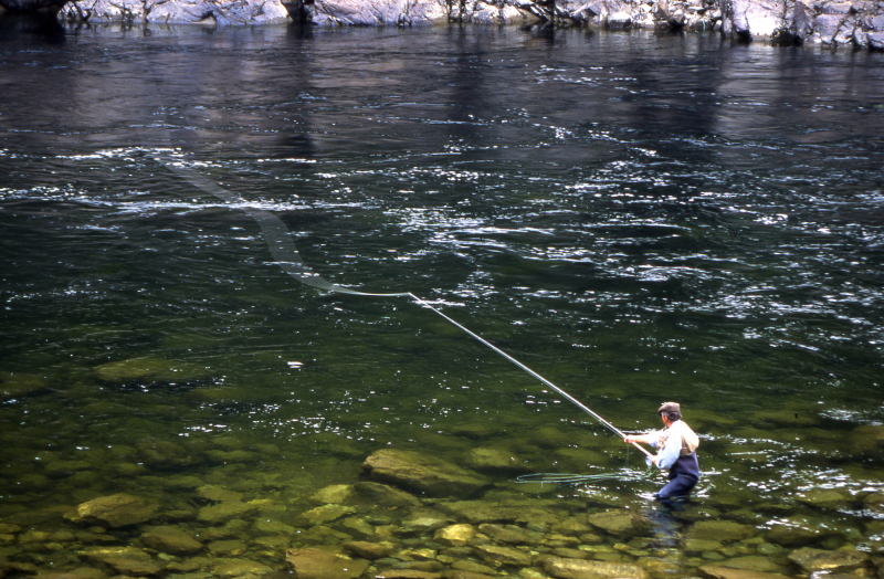
Photo: Visit Grong -
Nidelva is the main river in Norway's Arendal drainage basin, located in the county of Agder. The river begins at the confluence of two rivers, the Nisserelva and the Fyreselv, and runs for 221.7 kilometers (137.8 miles). The confluence is near the village of Haugsjåsund in the municipality of Nissedal in the county of Vestfold og Telemark in southern Vestfold og Telemark. The river flows south into the Skagerrak near Arendal. The watershed covers 4,011 square kilometers (1,549 square miles) and has an average waterflow of 114.4 cubic metres per second (4,040 cu ft/s) near the mouth at Rykene. The river's highest recorded waterflow was 1,200 cubic metres per second (42,000 cu ft/s) in the autumn of 1987.
Before entering Agder county, the river briefly flows through Nissedal in Vestfold og Telemark county. It then flows through the municipality of Åmli. There, the river Gjøv joins the Nidelva. The large lake Nelaug is a man-made lake along the river that is used to generate electricity. It then passes through the municipalities of Froland and Arendal. For a time, the river served as a dividing line between the municipalities of Grimstad and Arendal. The river flows into the Skaggerak just northeast of Rykene in Arendal, between the mainland and the island of Hisøya.
The river is lined with sixteen hydroelectric power stations, making it one of Norway's most controlled drainage systems. The largest on the river are in Grimstad at Rygene, Froland at Evenstad, and Åmli at Jørundland. Salmon can be found from the mouth to the Evenstad power station, which is located 22 kilometers (14 miles) upstream and effectively blocks their path further upstream.
Length: 221.7 km (137.8 mi)
Photo: Gody.vn 
Photo: Wikipedia


