


Top 3 Highest Mountains in Benin

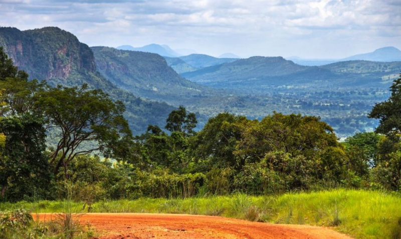
Benin is organized into four major regions that go from south to north. The low-lying, sandy coastal plain has a maximum width of 10 km (6 mi) and a maximum ... read more...height of 10 m (33 ft). It is marshy, with lakes and lagoons that connect to the seashore. The plateaus of southern Benin, which range in elevation from 20 to 200 meters (66 to 656 feet), are divided by valleys that flow north to south along the Couffo, Zou, and Oueme Rivers, and are classified by the World Wildlife Fund as part of the Guinean forest-savanna mosaic ecoregion. Then, surrounding Nikki and Savé, an area of flatlands interspersed with stony hills whose altitude seldom exceeds 400 m (1,312 ft). Finally, the Atacora mountain range stretches along the northwest border and into Togo, with the highest mountain in Benin, Mont Sokbaro, standing at 658 meters (2,159 ft)
-
Mont Sokbaro (sometimes spelled Sagbarao) is a mountain in Benin that is commonly referred to as the country's highest point, with an elevation of 658 meters (2,159 ft). This identification is being challenged since SRTM measurements at 10°17′22′′N 1°32′38′′E suggest an elevation of 672 meters (2,205 ft). This is 2.5 kilometers (1.6 miles) southeast of Kotoponga.
Mont Sokbaro is located near the source of the Mono River on the boundary between Benin's Donga Department and Togo's Kara Region. It's 58 kilometers (36 miles) from the town of Bassila. The hill is part of the Atakora Mountains' quartzite massif, which extends westward into the latter nation and is known as the Togo Mountains. Some of these are at greater heights than others. Lower ground with an average elevation of 550 meters may be found on Benin's eastern side (1,800 ft). Tchèmbèré, Aledjo-Koura, and Akaradè are nearby settlements. Hiking activities take place at the top of the hill, although the region may benefit from greater tourism development.
Height: 658 m (2,159 ft)
Location: Benin - Togo border
thegetaway.com 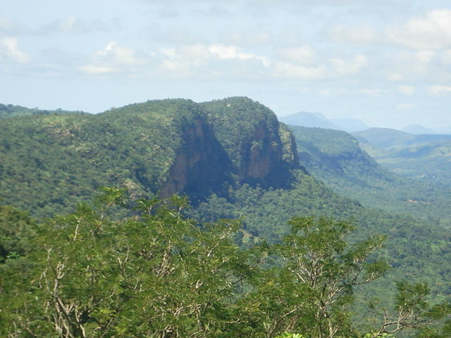
unseenbenin.wordpress.com -
Mont Goubono is in Benin, close to Ouroutou, Odo Igbo, and Odokoto. It is also close to Bono and Kikele. Mont Goubono has a latitude of 9.06623, a longitude of 1.73144, and GPS coordinates of 09 03′ 58.42′′ N and 01 43′ 53.18′′ E. Mont Goubono are one of the highest mountains in Benin after Mont Sokbaro. It is located in the central part of the country, 300 km north of the capital Porto-Novo, 613 meters above sea level above Mont Goubono.
The land around Mont Goubono is mostly flat. Mont Goubono is the highest point in the area. The nearest larger town is Bassila, 10.1 km southwest of Mont Goubono. The area around Mont Goubono is almost covered with barrenness and desolateness. There are about 12 people per square kilometer around Mont Goubono with a small population.
Height: 623 m (2,045 ft)
Location: Benin, West Africa, Africa
commons.wikimedia.org 
unseenbenin.wordpress.com -
Soubakperou (Soubakpérou) is a mountain in Benin (general), Benin (Africa) with the region font code Africa/Middle East. It has a population of 75,973 people and is located at a height of 323 meters above sea level. Soubakperou, also called locally Soubakpérou, is a Mountain in the state of Benin, Benin, in the Africa/Porto-Novo Time Zone. For correct charting of this place, Soubakperou's Latitude is 9.1421900 and Longitude is 2.1600200.
Its coordinates in DMS (Degrees Minutes Seconds) are 9°9'0" N and 2°10'0" E, or 9.15 and 2.16667. (in decimal degrees). It has the UTM location DL01 and the Joint Operation Graphics reference NC31-10. The current time is 05:08, and the sun rises at 09:00 and sets at 21:06 (Africa/Porto-Novo UTC/GMT+1).
Height: 620m (2011 ft)
Location: Benin, West Africa, Africa
sciencefocus.com 
peruvianandes.com


