


Top 5 Longest Rivers in Lithuania

Lithuania, formally the Republic of Lithuania, is a European Union republic. Lithuanian rivers are typical lowland rivers, with slow-flowing, meandering ... read more...valleys. The river network is thick due to the considerable rainfall: on average, there is 0.99 km of rivers running per 1 km2 of terrain. The rivers, however, are not uniformly distributed. The Samogitian Plateau, where it rains more regularly, and northern Lithuania have the largest concentrations. The Longest Rivers in Lithuania are listed below.
-
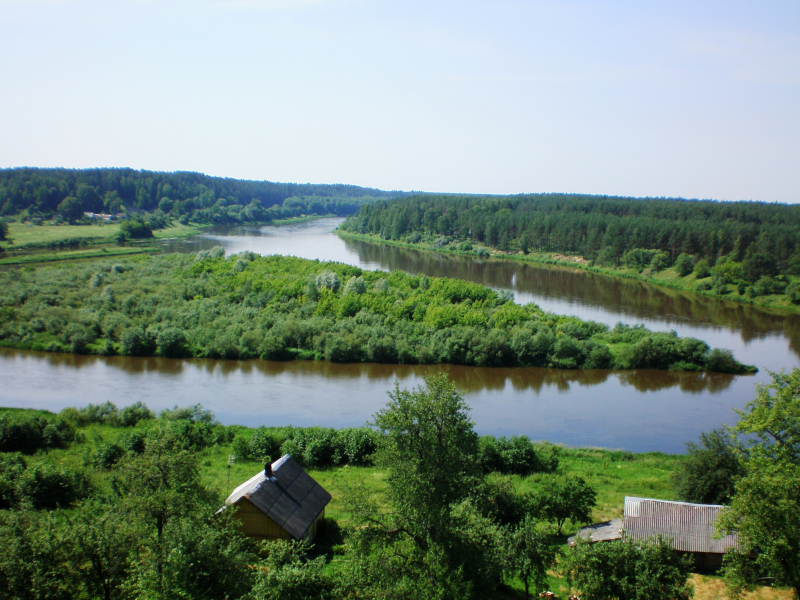
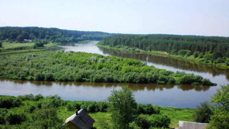
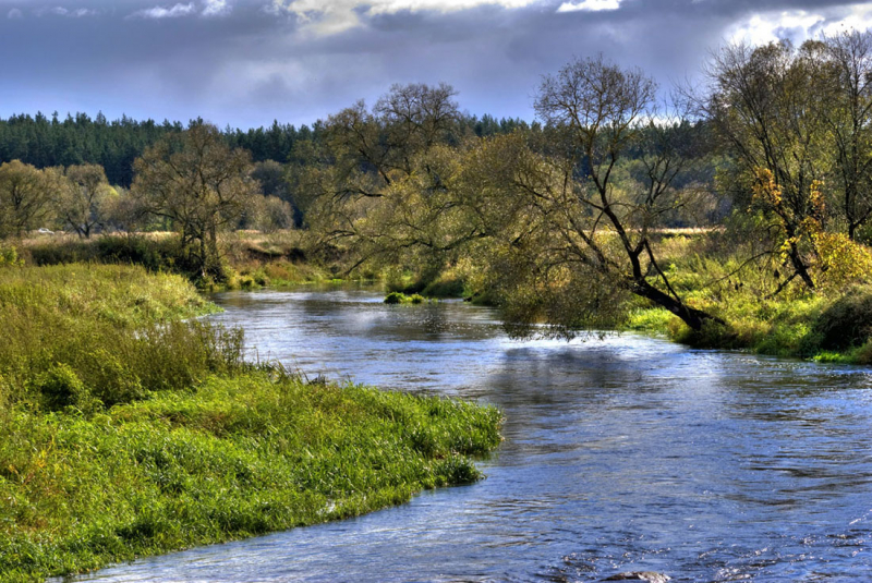
The Nemunas, sometimes known as the Nioman, Neman, or Memel, is the Longest River in Lithuania, and is a river in Europe that originates in central Belarus and runs through Lithuania before forming the northern boundary of Kaliningrad Oblast, Russia's western exclave, which follows its southern channel. It drains into the Curonian Lagoon, which is only tenuously connected to the Baltic Sea. It has a length of 937 kilometers (582 miles) and is considered a prominent Eastern European river. It runs mainly west to Grodno, about 12 kilometers (7.5 miles) from the Polish border, then north to Kaunas and west again to the sea.
It is navigable for the majority of its length and is the biggest river in Lithuania and the third-largest in Belarus. It begins with two minor headwaters that merge around 15 kilometers (9 miles) southwest of the village of Uzda – about 55 kilometers (34 miles) southwest of Minsk, the capital city. A 17-kilometer-long (11-mile-long) eastward meander adds to the Belarus–Lithuania boundary. Following that, the river makes noticeable loops over a small tectonic fault. Its drainage basin settled in the late Quaternary to be about along the border of the last glacial sheet and hence dates to between 25,000 and 22,000 years BC. It ranges in depth from 1 meter (3 ft 3 in) in the higher courses to 5 meters (16 ft) in the lower basin.
Length: 937 km
travel.sygic.com 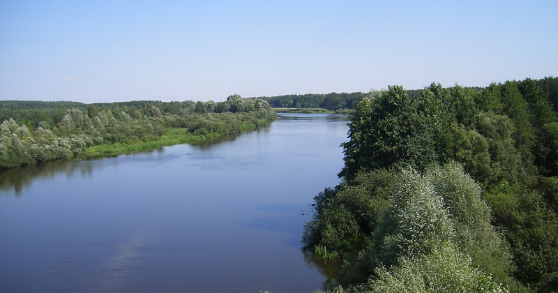
travel.sygic.com -
The Neris River rises in northern Belarus. It runs westward, passing past Vilnius (Lithuania's capital), and as its primary tributary, it flows into the Nemunas (Neman) in Kaunas in the country's south-central region. It is 510 kilometers long (320 mi). The river flows through Lithuania for 235 kilometers (146 miles) after passing through Belarus for 276 kilometers (171 miles). The Neris River connects the Lithuanian capitals of Kernav and Vilnius. Along with its banks are pagan Lithuanian burial grounds. Karmazin's historic burial mounds, with many legendary stones and a holy oak, are located 25 kilometers (16 miles) from Vilnius.
The origins behind the river's dual name as Neris by Lithuanians and Viliya (previously Velja, meaning "large, great" in Slavic) by Slavs are complicated. Even in Vilnius, there are toponyms that include both names, such as Neris in the riverbank names Paneriai and Paneriks, and Velja in the name Valakampiai, which means "an angle of Velja" in Lithuanian. Vilijampol (Vilija + polis, which means "polis by Vilija") is another name for a portion of Kaunas along the Neris river that was previously a distinct town.
Neris has taken you to the Neman 6 km3 of water throughout the years. The spring runoff accounts for 42 percent of the entire yearly amount of water in the summer, 18 percent in the fall, and 21 percent in the winter. Spring flooding often begins in mid-March and lasts until mid-May. Flooding caused a 4 m rise in the water level at the mouth of the Eimena, a 3 m rise in Vilnius, a 3.5 m rise in Jonavoje, and a 4 m rise in Kaunas. Floors during the flood - the Eimena average rises 8 m, 6 m in Vilnius, 7.5 m in Jonavoje, and 8 m in Kaunas. The water level will settle around mid-May during the summer. In July and August, at least, the water runs down the river. During the summer, rain often floods, causing the water level to climb an average of 1.2 m, and in extreme circumstances, up to 3.5 m. The largest measured summer flood discharges were 570 m3 / s in Vilnius and 954 m3 / s in Jonavoje.
Length: 510 km
greatruns.com 
greatruns.com -
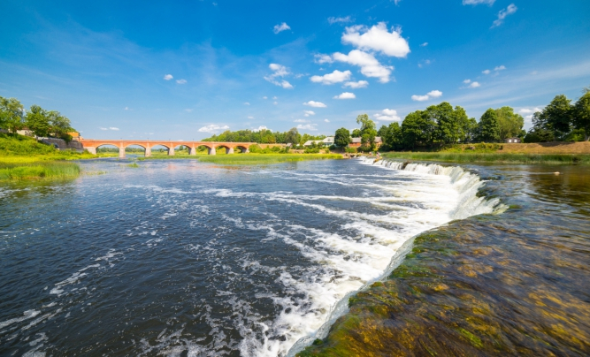
The Venta is a river that flows through northwestern Lithuania and western Latvia, and is one of the Longest Rivers in Lithuania. Its source is in the Lithuanian Šiauliai County, near Kuršėnai. It empties into the Baltic Sea near Ventspils, Latvia. Cities along the Venta in Lithuania include Uventis, Kurnai, Venta, Viekniai, and Maeikiai. The Venta river runs through the Latvian cities of Kuldga, Piltene, and Ventspils. Venta boasts Europe's widest waterfall, Venta Rapid.
The river has only one tributary that is more than 100 kilometers long, the Abava. Other significant tributaries are the Virvyia (99.7 km) and the Varduva (96 km), which run into the Venta at the Latvia–Lithuania border. The Avilys, a 20-kilometer-long tributary that feeds into the Venta River near Akmen district municipality, Siauliai County, northern Lithuania, is one of the smaller tributaries.
The Venta Rapid is Europe's largest waterfall, with views of flying fish in the spring and autumn. The waterfall's breadth is around 100—110 meters, and its height is 1.8—2 meters. The waterfall may be seen from both sides of the river, as well as from the historic brick bridge that spans the Venta, which is located 200 meters downstream of the waterfall. Every fall and spring, an interesting phenomenon occurs here, as the fish attempt to clear the rapid by jumping over it. Due to Duke Jacob's invention of these fishing gadgets, Kuldga was formerly known as a place where you could catch salmon in the air.
Length: 346 km
latvia.travel 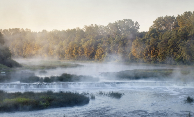
latvia.travel -
The Šešupė is a 298-kilometer-long river that runs through Poland (27 kilometers), Lithuania (158 kilometers), and Russia (62 km). The river flows for 51 kilometers along the boundary between Russia's Kaliningrad Oblast and Lithuania. The Šešupė begins at the Polish village of Szeszupka, about ten miles from the Polish-Lithuanian border, and flows into the Nemunas near the town of Neman, on the boundary between Lithuania and Kaliningrad Oblast. Kudirkos Naumiestis, Pilvikiai, Marijampol, and Kalvarija are major towns and cities along the river from the Nemunas to the source. On the other side of the river, there are sections of Kaliningrad and Lithuania, including a tiny island that is largely Russian but includes a Lithuanian portion.
The name Šešupė's etymology is unclear. In Lithuanian, up means river. There is an association with the word šeši, which means number six in Lithuania, and the river name could be interpreted as "river of six" or simply "six rivers," but the most likely etymology is that part of the name "e" is derived from the term šėšėlis, which means shadow, and the river name itself could be translated as a "shadow river."
Length: 298 km
mapio.net 
mapio.net -
The Nevėžis is Lithuania's sixth-longest river and a major tributary of the Nemunas. It has a length of 209 kilometers (130 miles) and runs entirely inside the borders of Lithuania. After the Šventoji, it is Lithuania's second-longest river that runs entirely inside its borders. Its headwaters are in the Anykščiai District Municipality, and the river runs northwest at first, but then swings southwest at Panevėžys, and discharges into the Neman slightly west of Kaunas near Raudondvaris after passing through Kėdainiai.
The river inspired the names of several things, notably Panevezys, Lithuania's fifth biggest city. Its name translates as "Town near Nevis." The rivers FK Nevis and KK Nevis are also named after them. The Nevis is significant in Lithuanian culture since it runs through the heart of the country. During the Middle Ages, the river was seen to constitute a natural boundary between two Lithuanian regions: Samogitia and Auktaitija.
The Krekenava Regional Park was created in 1992 to protect the Middle Nevis ecology and natural surroundings. The park is unusual in that it breeds and works to save European bison from extinction. Even with two canals delivering water to Nevis, the lake gets relatively shallow during a dry summer. It is usually between 4 and 9 meters deep. In recent years, a number of grass carp have been released into the river to eliminate aquatic weeds. The Nevis was getting more overrun with weeds as a result of its low water level, sluggish current, and a flood of fertilizer runoff from farmers. It was thought that the introduction of grass carp would aid in the process's management. Critics said that the fish would perish in the frigid temperature. Local fishermen, though, continue to capture carp imported a few years ago.
Length: 209 km
kedainiutvic.lt 
kedainiutvic.lt


