


Top 10 Highest Mountains In Bolivia

Bolivia is a South American country located in the center of the continent. Bolivia is notable for its topography and ecology, as it is home to South America's ... read more...largest desert and largest lake, the Atacama Desert and Lake Titicaca. The country also has a portion of the Amazon Basin jungle. Bolivia is also recognized for its high-altitude cities and the Andes Mountains, which run the length of the country. Toplist has compiled a list of the top 10 highest mountains in this lovely country!
-
With a height of 20,827 feet, Parinacota is Bolivia's sixth tallest mountain. The mountain is a dormant stratovolcano on the Bolivian-Peruvian border, situated in Bolivia's Oruro Department and Chile's Arica and Parinacota Region. It also happens to be on the border of two national parks, Bolivia's Sajama National Park and Chile's Lauca National Park. It is part of the Payachata volcanic group, and the Andes Mountains are its parent range. Lava flows have been formed by these cones. Lava domes and andesitic lava flows form a platform beneath the volcano.
Parinacota is a huge dormant stratovolcano that last erupted between 10 BC and 590 AD, creating the Chungará Lake in the process. Bolivian Carlos Terán and Austrian Joseph Prem made the first climb of Parinacota in 1928.
During the Holocene, Parinacota erupted in a series of effusive and explosive eruptions, the most recent of which occurred about 200 years ago. While no eruptions have been recorded, tales among the indigenous Aymara people suggest that they may have witnessed one. In the future, renewed activity in Parinacota is likely, however the region's low population density would limit the amount of harm that may occur. Some communities in Bolivia and Chile, as well as a regional route, could be impacted by a fresh eruption.
Location: Bolivia/Chile
Range: Cordillera Occidental
Elevation: 6342 m | 20807 ft
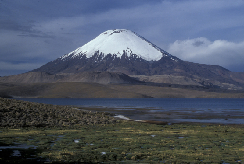
Photo source: Global Volcanism Program 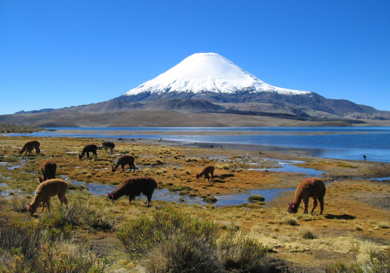
Photo source: Wikipedia -
Illampu, Bolivia's fourth tallest mountain, rises to a height of 20,892 feet. The Cordillera Real, a sub-range of the Andes Mountains, is the mountain's parent range, which is located in the La Paz Department. To the north of the Ancohuma Mountain and to the east of Lake Titicaca, the mountain can be found. The Laguna Glaciar, the world's 17th highest lake, is located in the massif between Illampu and Ancohuma. In 1928, Austrians Erwin Hein and Alfred Horeschowsky, as well as Germans Hans Pfann and Hugo Hörtnagel, made the first climb of the peak.
Illampu, despite being lower than Janq'u Uma, has a higher peak, greater local relief, and is a slightly more difficult climb. In fact, it boasts "the most difficult regular route on any of Bolivia's 6,000-meter summits." With snow slopes up to 65 degrees, the simplest approach, through the Southwest Ridge, is graded AD (Fairly Difficult). It can be reached through a high camp on the massif's north flank. Hans Pfann, Alfred Horeschowsky, Hugo Hörtnagel (Germans), and Erwin Hein (Austria) were the first to climb the peak through this route on June 7, 1928. (Austrian). The "German Route" on the southwest face and the "South Face Route," both approached from the west side of the massif, are two further options.
Location: Bolivia
Range: Cordillera Real
Elevation: 6383 m | 20942 ft
Photo source: Andean Destinations 
Photo source: Wikipedia -
Ancohuma, also known as Janq'u Uma, is Bolivia's third highest peak. At 21,085 feet, it is the tallest mountain in the United States. The mountain is found in the Department of La Paz, and like Illampu, it is part of the Cordillera Real. The mountain is located to the east of Lake Titicaca and to the south of the Illampu Mountain. Rudolf Dienst and Adolf Schulze, two Germans, made the first climb of the mountain in 1919.
Although Ancohuma is higher than Illampu, it is a gentler mountain with less local relief and a little simpler ascent. Rudolf Dienst and Adolf Schulze were the first to summit the peak in 1919. Their route, which is still the most straightforward, ascends the southwest face and is graded PD (not very difficult). On the northwest ridge and the west face, there are more routes. The mountain can be approached from the west or northeast, depending on the route selected; either approach takes two to three days from Sorata.
Location: Bolivia
Range: Cordillera Real
Elevation: 6427 m | 21086 ft
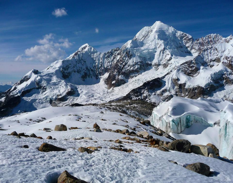
Photo source: Thaki Travel 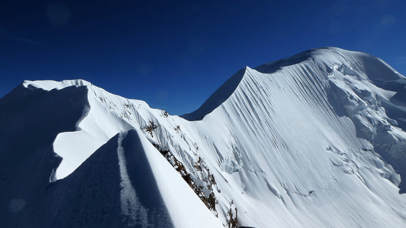
Photo source: Andean Destinations -
Illimani, Bolivia's second tallest peak, rises to a height of 21,122 feet (6,438 meters). The mountain lies in the La Paz Department, and its parent range, like Illampu and Ancohuma, is the Cordillera Real. The peak is visible from the cities of La Paz and El Alto, which serve as the headquarters of the Bolivian government. The mountain contains four main summits, the tallest of which is Nevado Illimani, the south summit, which is a renowned mountain climbing destination. At 4,570 meters (15,000 feet) above sea level, the snow line is reached, and glaciers can be observed on the northern slope at 4,983 meters (16,350 ft).
In 1898, Englishman William Martin Conway and Swiss-Italians Antoine Maquignaz and Louis Pellissier made the first known ascent of the mountain. Eastern Air Lines Flight 980 crashed into the mountain on January 1, 1985, killing all 29 people on board. Illimani is mostly made up of granodiorite, which was intruded into the sedimentary rock that makes up the Cordillera Real during the Cenozoic epoch.
Illimani is a notable landmark in El Alto and La Paz, and can be seen from both cities. Many local songs have been written about the mountain, the most famous of which is "Illimani," which contains the refrain "Illimani, Illimani, centinela t eres de La Paz! Illimani, Illimani, perla andina eres de Bolivia!" ("Illimani, Illimani, you are the sentinel of La Paz! Illimani, Illimani, you are Bolivia's andean pearl!")
Location: Bolivia
Range: Cordillera Real
Elevation: 6438 m | 21122 ft
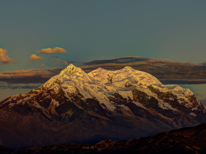
Photo source: Bolivia Travel Site 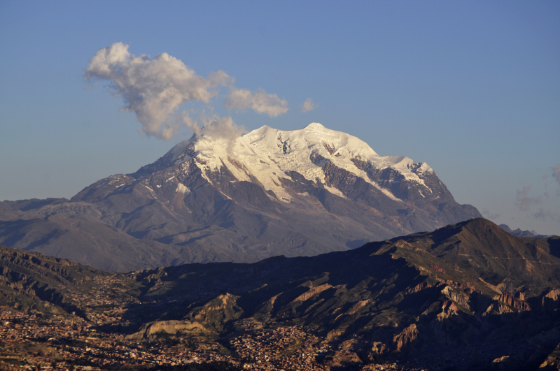
Photo source: Wikipedia -
Sajama, also known as Nevado Sajama, is Bolivia's tallest peak, reaching 21,463 feet. The Cordillera Occidental is the parent range of the mountain, which is located in the Oruro Department. Sajama, like Illampu Mountain, is part of the Sajama National Park. Sajama, like Illampu, is an extinct stratovolcano, albeit it is unknown when it last erupted. The mountain is conical in shape and features a summit crater that looks to be related to the flat top plateau of Sajama due to its ice, although other sources do not confirm the presence of a crater. Sajama is sandwiched between two climate regimes, one westerly with a dry environment and the Southeast Pacific High, and the other easterly with a moisture atmosphere.
The mountain is characterized by parasitic vents and a coating of lava fragments and volcanic ash below 4,200 meters (13,800 feet). The secondary summits of 5,031 meters (16,506 feet) and 5,161 meters (16,932 feet) west and east-northeast from Sajama are named Cerro Huisalla and Huayna Potosi, respectively. The treeline of the small tree Polylepis tarapacana can be found on the volcano as high as 17,060 feet above sea level, making it one of the highest treelines on the planet. Josef Prem and Wilfrid Kühm, Austrians, made the first climb of the mountain in 1939.
Location: Bolivia
Range: Cordillera Occidental
Elevation: 6550 m | 21490 ft
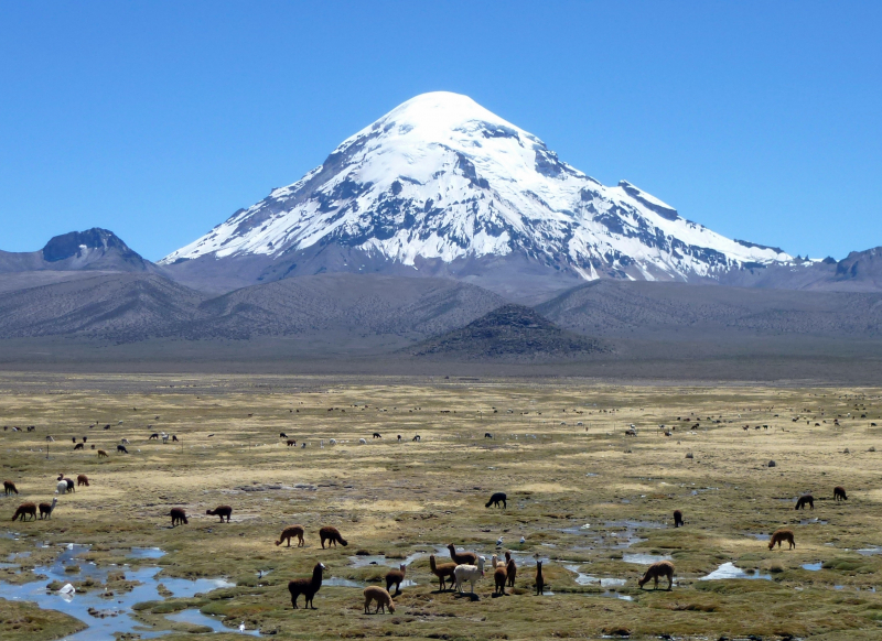
Photo source: WIkipedia 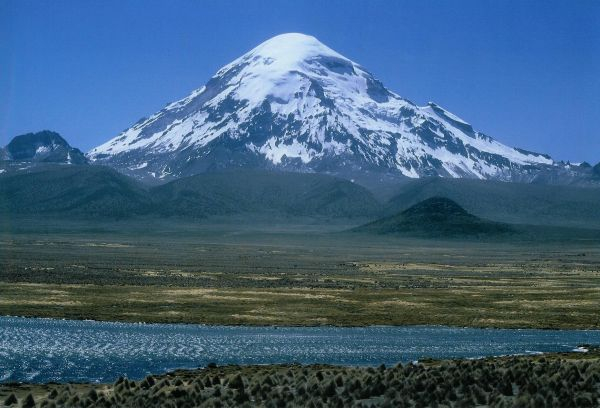
Photo source: Wikipedia -
Pomerape is a stratovolcano located on the Chilean-Bolivian border (Oruro Department, Sajama Province, Curahuara de Carangas Municipality). It is part of the Payachata volcano complex, which also includes Parinacota Volcano to the south. The word "Payachata" alludes to their physical appearance and signifies "twins." Lower on the northern side, glaciers can be seen at elevations of 5,300–5,800 meters (17,400–19,000 feet).
Pomerape is a lava dome complex with lava flows that have been deposited on top of the domes. Around 200,000 years ago, it was active. The lava domes formed initially and were later buried by the true volcanic cone, which is made up of hornblende andesite rather than rhyolitic-dacitic domes. At this time, the "Chungará Andesites" and Parinacota's lava dome complex were formed. Pomerape is linked to a mafic magma erupting from an adventive vent. The main cone last erupted 106,000 +/- 7,000 years ago, whereas the adventive vent dates from 205,000 +/- 24,000 years ago.
The east ridge is alpine grade PD for climbing the volcano. On the south face, there are more difficult routes, some of which are on a 50-degree snow/rubble slope. A camp can be set up for these routes at 5,300 meters (17,390 feet) in the saddle between Parinacota and Pomerape. Penitentes (tall ice-blade needles) can be a major challenge depending on the season, making the ascent physically tough or impossible.
Location: Bolivia/Chile
Range: Cordillera Occidental
Elevation: 6282 m | 20610 ft
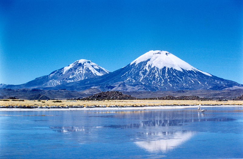
Photo source: Thousand Wonders 
Photo source: Wikipedia -
Chearoco, Chiaraco, or Chiaroco (all likely derived from the Aymara ch'iyara dark, juqhu muddy site) is a peak in Bolivia's Cordillera Real. It stands at a height of approximately 6,127 meters (20,102 ft). ASTER 6078 meters and TanDEM-X 6106 meters are two other digital elevation models that are available. The closest important col rises to a height of 5049 meters, resulting in a topographic prominence of 1055 meters. According to the Dominance System, Chearoko is a Mountain Massif with a dominance of 17.28 percent. Ancohuma is its parent mountain, with a topographic isolation of 18.4 kilometers. It is located in the southeast of the peak of Aman Pata in the La Paz Department, Larecaja Province, Guanay Municipality. Chearoco is located between Qalsata and Chachakumani in the northwest and southeast, respectively.
The mountain's Aymara name Chiar Jokho corresponds to the names of the neighboring locality (Chiar Jokho) and the nearby river Ch'iyar Juqhu (Chiar Jokho, Chiar Joko). Erwin Hein (Austria), Alfred Horeschowski, Hugo Hoertnagel, and Hans Pfann (Germany) were the first to climb Chearoko on June 25, 1928.
Location: Bolivia
Range: Cordillera Real
Elevation: 6104 m | 20026 ft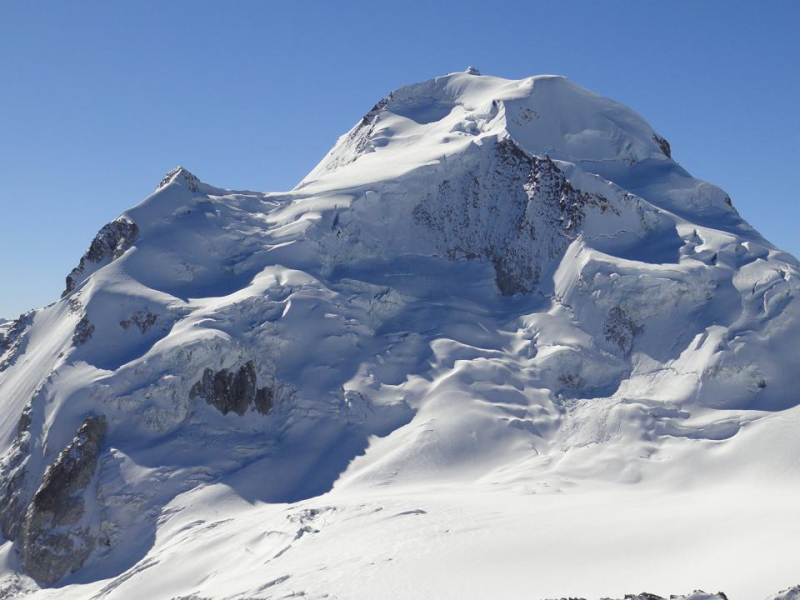
Photo source: Thaki Travel 
Photo source: Wikipedia -
The closest high mountain to La Paz is Huayna Potosi. It is about 15 miles due north of the city and is surrounded by towering mountains, making it Bolivia's most popular climb. The standard climbing path is a rather simple glacier climb with several crevasses and a hard rise to the peak. The Huayna Potosi West Face, on the other hand, is Bolivia's largest mountain face. This 1000 meter high face has several tough snow and ice approaches.
Rudolf Dienst and Adolf Schulze, two Germans, made the first ascent of the standard route in 1919. This mountain is described in some climbing manuals as the "easiest 6000er in the world," but this claim is questionable. The easiest route, with a UIAA rating of PD, involves an exposed ridge and parts of moderately steep ice. In terms of technical difficulties, there are numerous 6000m mountains that are easier to climb. As a result, Huayna Potosi has been dubbed the "easiest 6000-meter climb" since the height gain from trailhead to summit is less than 1400 meters, with easy access from La Paz. Climbers will have an easier time acclimating because La Paz is at 3640 meters.
In 1877, a group of six German climbers attempted the first ascent of Huayna Potosi. They set out for the unclimbed mountain with no suitable equipment and little practical knowledge. Their failed endeavor ended in catastrophe. At an altitude of roughly 5600m, four climbers died; the remaining two managed to withdraw in deteriorating conditions, but died of fatigue shortly after reaching the Zongo Pass. An expedition of Austrian climbers attempted the peak ascent again 21 years later, on September 9, 1898, but were forced to descend after five days at 5900m. Finally, in 1919, Germans R. Dienst and O. Lhose climbed the mountain on the east face and reached the south peak (which is marginally higher than the north summit) on a route that would subsequently become the present usual route, with some variations.
Location: Bolivia
Range: Cordillera Real
Elevation: 6088 m | 19974 ft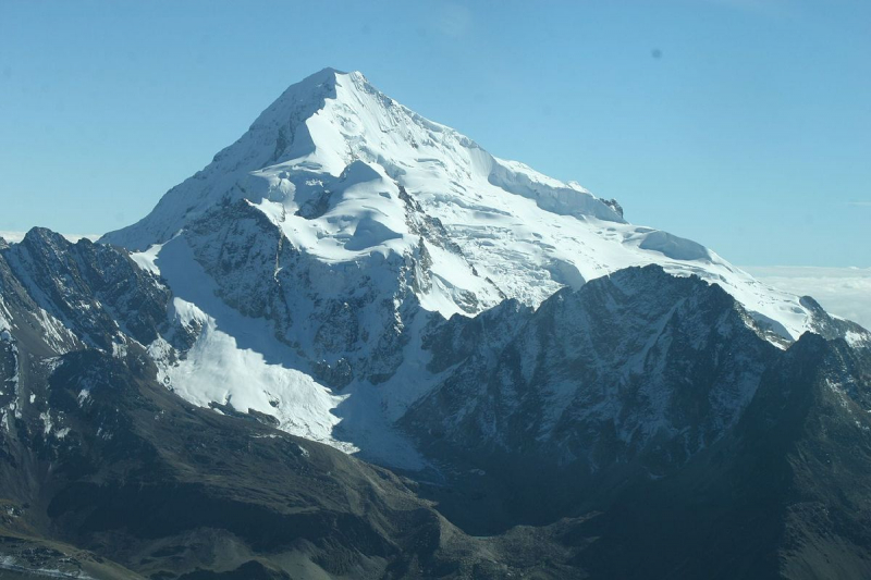
Photo source: Wikimedia Commons 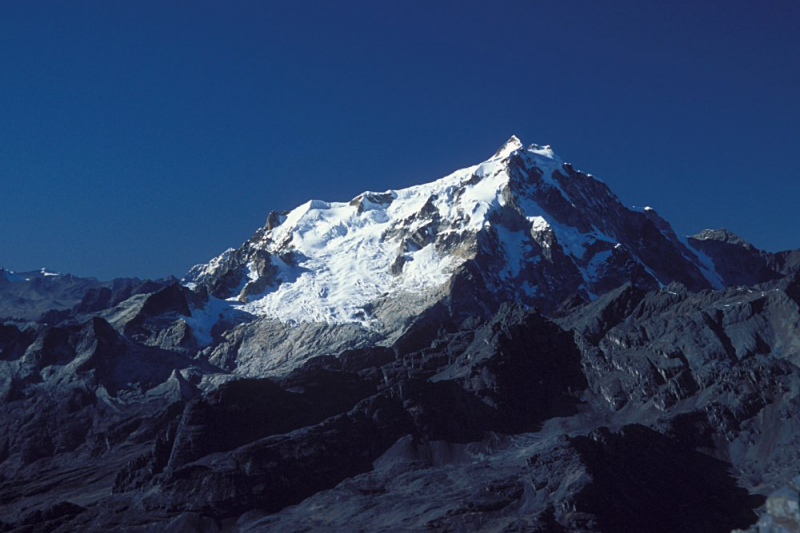
Photo source: Wikipedia -
Chachacomani (perhaps derived from Quechua chachakuma, a medicinal plant) is a peak in Bolivia's Cordillera Real, east of Lake Titicaca. It is located southeast of Chearoco in the La Paz Department, Larecaja Province, Guanay Municipality. Wari Umaa in the southwest and Qillwani in the northwest are two of the closest mountains. F. Fritz, F. Buchholtz (Germany), G. Moller, D. Doore, I. Paz, and G. Sanjinez (Bolivia) were the first to climb Chachacomani on January 8, 1947.
The mountain, which stands at 6,074 meters (19,928 feet) above sea level, is said to be one of the Cordillera Real's least hiked peaks. Other data from available digital elevation models include 6038 meters from SRTM, 6043 meters from ASTER, and 6084 meters from TanDEM-X. The closest major col is 5479 meters high, resulting in a 595-meter topographic prominence. According to the Dominance System, Chachacomani is a Mountain with a 9.8 percent dominance. Chearoko is its parent summit, with a topographic isolation of 4.3 kilometers. The exact height has never been determined, and it could vary by up to 20 meters (66 feet), but the top is estimated to be above 6,000 meters (19,685 feet). The deep and sheltered valleys surrounding the mountain, in particular, provide numerous varied microclimates, which result in lakes and other formations that sustain a diverse range of bird species.
Location: Bolivia
Range: Cordillera Real
Elevation: 6074 m | 19928 ft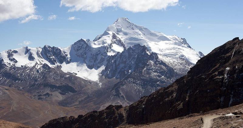
Photo source: Evaneos 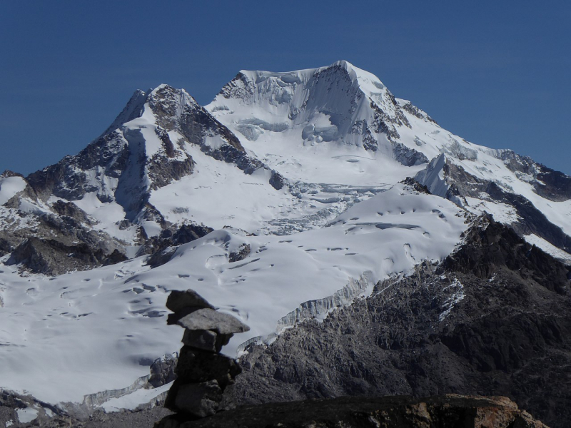
Photo source: WIkipedia -
Acotango is the highest and most central of a collection of stratovolcanoes that straddle the Bolivian-Chilean border. It stands at a height of 6,052 meters (19,856 feet). Kimsa Chata is made up of three mountains: Acotango, Umurata (5,730 meters (18,799 feet) to the north, and Capurata (5,990 meters (19,652 feet) to the south. The group is arranged in a north–south direction. Sergio Kunstmann, Pedro Rosende, and Claudio Meier (Chile) made the first modern ascent of Acotango on October 14th, 1965. The remains of firewood are thought to have been discovered at the peak of Acotango by Pedro Rosende, a Chilean adventurer. As a result, the peak is supposed to have been one of the highest Incan Andean sanctuaries. However, more research is required to confirm this information.
Although the Acotango volcano has been badly eroded, a lava flow on its northern face is morphologically young, implying that it was active during the Holocene. Later study suggests that the lava flow is Pleistocene in age. On dacites from Acotango, argon-argon dating has revealed dates of 192,0008,000 and 241,00027,000 years. Glacial action has exposed hydrothermally altered sections of the interior volcano. Glacial moraines can be found at an altitude of 4,200 meters (13,800 feet), although a current ice cover can only be found above 6,000 meters (20,000 feet).In the Sajama and Lauca National Parks, the volcano is a popular hiking path. It is located on the border of the two provinces: Chile's Parinacota and Bolivia's Sajama. Its slopes are located within the administrative boundaries of two cities: Putre, Chile, and Turco, Bolivia. Due to land mines, climbing the top from the Chilean side is risky; however, climbing the summit from the Bolivian side is quite safe. The southern ascent begins with a glacier crossing and continues via an abandoned copper mine.
Elevation: Bolivia/Chile
Range: Cordillera Occidental
Elevation: 6052 m | 19856 ft
Photo source: South Treks 
Photo source: Wikipedia


