


Top 10 Highest Mountains in Mexico

Mexico is located in southern North America and covers an area of more than 760,000 square miles. The Sierra Madre Oriental and Sierra Madre Occidental ... read more...mountain ranges run from north to south across the country. The Trans-Mexican Volcanic Belt runs from the east to the west coast of Mexico and contains some of the country's highest elevations. This article looks at some of Mexico's tallest mountains.
-
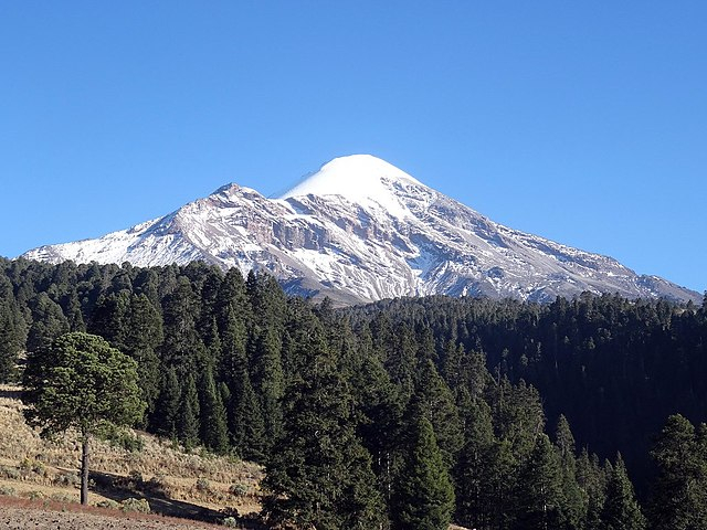
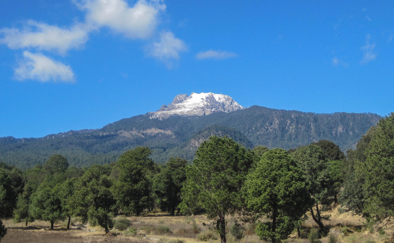
The first one in Top 10 Highest Mountains in Mexico that Toplist would like to introduce to you is Pico De Orizaba. Pico de Orizaba, also known as Citlaltépetl, is an inactive stratovolcano that is Mexico's highest mountain and the third highest in North America, after Denali in Alaska and Mount Logan in Canada. Pico de Orizaba is also North America's highest volcanic peak. It is located at the eastern end of the Trans-Mexican Volcanic Belt, on the border between the states of Veracruz and Puebla, and rises 5,636 meters (18,491 feet) above sea level. The volcano is currently dormant but not extinct, with the most recent eruption occurring in the nineteenth century. It is the world's second most prominent volcanic peak, after Africa's Mount Kilimanjaro and it is also ranked 16th in terms of topographic isolation.
Its peak, located about 110 kilometers (68 miles) west of Veracruz, is visible to ships approaching the port in the Gulf of Mexico, and at dawn, rays of sunlight strike the Pico while Veracruz remains in shadow. Pico de Orizaba's topography is asymmetrical from the crater's center; the eastern face is the steepest side of the volcano, while the northwestern face is the most gradual. The gradual slopes of the volcano's northwestern face allow for the presence of large glaciers and are the most traveled route for hikers traveling to the summit.
Every year, a large number of international climbers visit Pico de Orizaba.
Location: Veracruz, Mexico
Elevation: 5,636 m (18,491 ft)
en.wikipedia.org 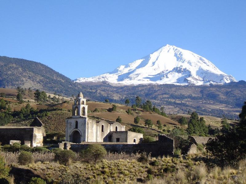
tripadvisor.com.vn -
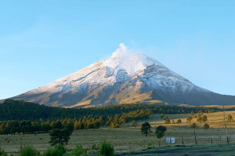
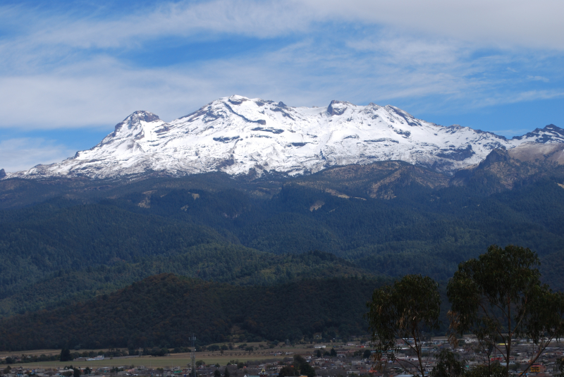
The second one in Top 10 Highest Mountains in Mexico that Toplist would like to introduce to you is Popocatépetl. Popocatépetl is an active stratovolcano in central Mexico, located in the states of Puebla, Morelos, and Mexico. It is located in the Trans-Mexican volcanic belt's eastern half. It is the second highest peak in Mexico, after Citlaltépetl (Pico de Orizaba), at 5,426 m (17,802 ft) (18,491 ft).
The high saddle known as the "Paso de Cortés" connects it to the twin volcano of Iztaccihuatl to the north. The Izta-Popo Zoquiapan National Park, which contains the two volcanoes, is named after them.
Popocatépetl is located 70 kilometers (43 miles) southeast of Mexico City, from which it can be seen on a regular basis, depending on atmospheric conditions. Until recently, the volcano was one of three tall peaks in Mexico with glaciers, along with Iztaccihuatl and Pico de Orizaba. Glaciers such as Glaciar Norte (North Glacier) shrank dramatically in the 1990s, partly due to warmer temperatures but primarily due to increased volcanic activity. Popocatépetl's glaciers had vanished by early 2001; ice remained on the volcano but lacked the characteristic features of glaciers, such as crevasses.
Popocatépetl's lava has historically been predominantly andesitic, but it has also erupted large amounts of dacite. The magma produced in the current cycle of activity is a mixture of the two, with andesites being rich in magnesium.
Location: Mexico-Puebla-Morelos, Mexico
Elevation: 5,426 m (17,802 ft)
en.wikipedia.org 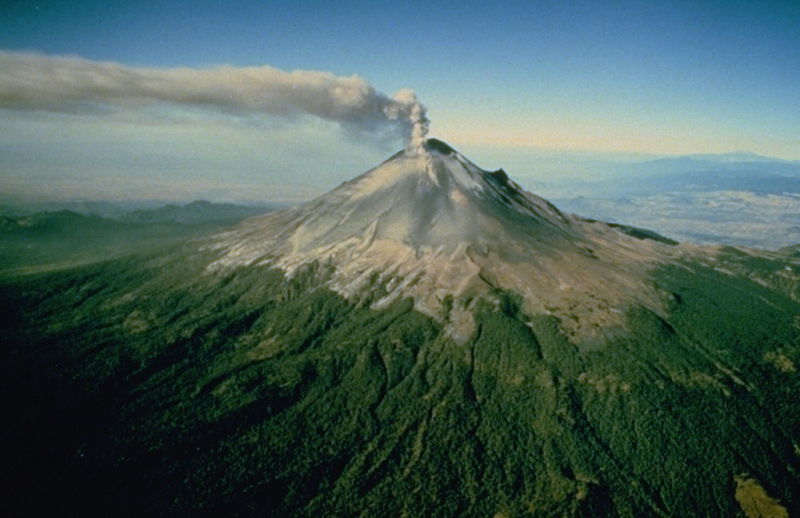
volcano.si.edu -
The third one in Top 10 Highest Mountains in Mexico that Toplist would like to introduce to you is Iztaccihuatl. Iztaccíhuatl is a 5,230 m (17,160 ft) dormant volcanic mountain in Mexico located within Izta-Popo Zoquiapan National Park on the border between the states of Mexico and Puebla. It is the third highest peak in Mexico, after Pico de Orizaba (5,636 m/18,491 ft) and Popocatépetl (5,426 m) (17,802 ft).
The name "Iztaccíhuatl" is Nahuatl for "White woman," and it refers to the four individual snow-capped peaks that, when viewed from the east or west, resemble the head, chest, knees, and feet of a sleeping female. Iztaccíhuatl is located to the north of Popocatépetl, with which it is linked by the high altitude Paso de Cortés. Depending on atmospheric conditions, Iztaccíhuatl can be seen from Mexico City, 70 kilometers (43 miles) to the northwest, for much of the year. The first recorded ascent was in 1889, though archaeological evidence suggests that the Aztecs and other cultures climbed it prior to that. It is Mexico's lowest peak with permanent snow and glaciers.
The massive 450 km3 (110 cu mi) volcano's summit ridge is a series of overlapping cones built along a NNW-SSE line to the south of the Pleistocene Llano Grande caldera. There have been Pleistocene and Holocene andesitic and dacitic eruptions from vents at or near the summit. Flows and tuff beds post-dating glaciation, approximately 11,000 years ago, cover areas near the El Pecho summit vent. El Pecho and a depression at 5,100 m (16,700 ft) along the summit ridge midway between El Pecho and Los Pies are the most recent vents.
Location: México and Puebla, Mexico
Elevation: 5,230 m (17,160 ft)
en.wikipedia.org 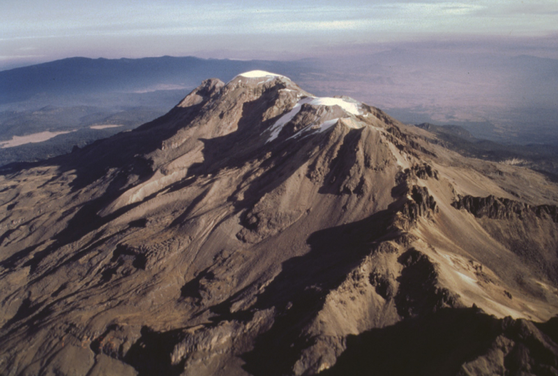
volcano.si.edu -
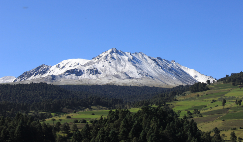
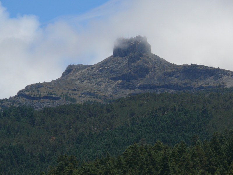
The fourth one in Top 10 Highest Mountains in Mexico that Toplist would like to introduce to you is Nevado de Toluca. The Nevado de Toluca is a stratovolcano in central Mexico, about 80 kilometers (50 miles) west of Mexico City and near the city of Toluca. It is Mexico's fourth highest peak, after Pico de Orizaba, Popocatépetl, and Iztaccíhuatl. The volcano and the surrounding area have been designated as a national park.
The summit caldera of the volcano is 1.5 kilometers (0.93 miles) wide and open to the east. The highest peak, Pico del Fraile (Friar's Peak), is located on the southwest side of the crater, and the second highest, Pico del Aguila (Eagle's Peak), is located on the northwest.
On the basin's floor, at about 4,200 m (13,800 ft), there are two crater lakes: the larger Lago del Sol (Sun Lake) and the smaller, but deeper, Lago de la Luna (Moon Lake).
A road used to run into the caldera and to the lakes, but it is now gated 2 kilometers before the lakes.
Nevado de Toluca appears flat-topped from the southeast, like shoulders without a head. A mythical explanation is provided by a Nahuatl legend (recounted as part of the legends of Popocatépetl and Iztaccíhuatl).
Location: Texcaltitlán, México, Mexico
Elevation: 4,680 m (15,350 ft)
en.wikipedia.org 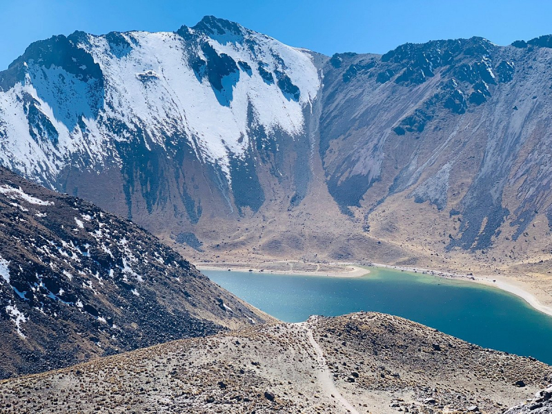
tripadvisor.com -
The fifth one in Top 10 Highest Mountains in Mexico that Toplist would like to introduce to you is Malinche. La Malinche, also known as Matlalcueye or Malintzin, is an active volcano in Mexico that has been dormant for the last 3,100 years. It is located in the states of Tlaxcala and Puebla. Its summit is officially 4,461 meters (14,636 feet) above sea level, but GPS measurements show that it is closer to 4,440 meters (14,567 feet). It is Tlaxcala's highest peak, Puebla's fifth highest, Mexico's sixth highest, North America's 23rd highest, and the world's 252nd highest. It rises 1,908 metres (6,260 feet) above Huamantla, 2,461 metres (8,074 feet) above Villa Vicente Guerrero, 2,221 metres (7,287 feet) above Tlaxcala, and 2,299 metres (7,543 feet) above Puebla. Tlaxcala is 22.4 kilometers (13.9 miles) away, Puebla is 28.3 kilometers (17.6 miles), and Mexico City is 118 kilometers (73 miles). Near the summit, the weather is cold, but on the lower slopes, it is mild.
The Tlaxcaltecs named the peak Matlalcueitl, which translates to "[Lady of the] Blue Skirt," after Matlalcueitl, a rain and song goddess who was thought to be the local equivalent of Chalchiuhtlicue. The Spanish simply called it Sierra de Tlaxcala ("Tlaxcalan Range"). The current name, Malinche or Malintzin, became popular in the 17th century and honors the woman who served as an interpreter for Hernán Cortés during the Aztec Empire's conquest.
This volcano is part of the Trans-Mexican Volcanic Belt and is located within the Parque Nacional La Malinche on the border of the states of Tlaxcala and Puebla. The park is the fifth largest of Mexico's 85 peaks. It has a total area of 458.52 square kilometers (177.04 square miles), roughly two-thirds of which belongs to Tlaxcala and one-third to Puebla. The park has a diameter of about 24 kilometers (15 mi).
Location: Tlaxcala / Puebla, Mexico
Elevation: 4,461 m (14,636 ft)
en.wikipedia.org 
commons.wikimedia.org -
The Nevado de Colima volcano is an ancient volcanic massif located in the Mexican state of Jalisco, in the western part of the country. It has a height of 4270 meters above sea level and no volcanic activity. Its summit has been severely eroded by fire, making it difficult to determine some aspects of its violent history. Today, remains of lava materials in the volcano and pyroclastic flows from the snow-capped mountain more than 80 kilometers away from the crater can be found due to a catastrophic eruption accompanied by avalanches and voluminous lahars that is thought to have occurred before the Pleistocene.
Unlike the rest of the country's large stratovolcanoes, which are associated with the subduction of the Cocos plate beneath the North American plate, the Jalisco volcanic complex is associated with an irregular tectonic movement, which is fed by the transfer of the Jalisco Tectonic Block to the Rivera sub-plate. This movement shifts Jalisco's western sector to the west. It is situated in an area characterized by the formation of grabens and geological faults that run through the state's central region, forming a great horseshoe from Jalisco to Tepic.
The Nevado's vegetation consists of temperate and cold forests of pine-oak, fir, and juniper. There is an ecosystem known as alpine tundra at an altitude of 4,000 meters above sea level, where grasses and mosses are the dominant plants because trees (pines, oyamels) stop growing at this altitude. The humidity conditions of the high mountains, as well as the warm currents that come from the south-west orientation (Colima), provide special conditions for habitats that benefit a wide range of animal species.
Location: Jalisco, Mexico
Elevation: 4270 m (14,009 ft)
commons.wikimedia.org 
peakvisor.com -
Cofre de Perote, also known by its Nahuatl names Naupa-Tecutépetl (from Nāuhpa-Tēuctēpetl) and Nauhcampatépetl, both of which mean "Place of Four Mountains" or "Mountain of the Lord of Four Places", is an inactive volcano in the Mexican state of Veracruz, at the point where the Trans-Mexican Volcanic Belt, which contains all of Mexico's Cofre de Perote is Mexico's eighth highest mountain peak, rising 4,282 metres (14,049 feet) above sea level.
Cofre de Perote is a shield volcano with a very different shape than the stratovolcanic Pico de Orizaba, which is located about 50 kilometers (31 miles) to the southeast. A cofre is a coffer, and the name refers to a volcanic outcropping on the shield that serves as the mountain's peak. The town of Perote, Veracruz, after which the mountain is named, is located to the north.
In 1937, the Mexican government designated the area surrounding the volcano as Cofre de Perote National Park. Cofre de Perote has a humid alpine climate (Köppen climate classification ET), with no dry season and more rain in the summer and autumn.
Location: Perote Municipality, Veracruz, Mexico
Elevation: 4,282 m (14,049 ft)
en.wikipedia.org 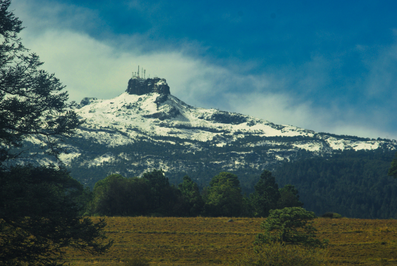
commons.wikimedia.org -
Tacaná is the second highest peak in Central America, rising 4,060 meters (13,320 feet) in the Sierra Madre de Chiapas region of northern Guatemala and southern Mexico. It is also known as Volcán Tacina in Mexico.
The volcano is located in Guatemala's Tacaná municipality of the San Marcos Department, and in Mexico's Cacahoatán and Unión Juárez municipalities of Chiapas state.
Its last known eruption was in 1986, a small phreatic eruption in May, but it is still considered dangerous to the more than 250,000 people who live nearby.
Tacaná is the first of hundreds of volcanoes in a 1,500 km (930 mi) row, arranged NW to SE, parallel to Central America's Pacific Ocean coast, known as the Central American Volcanic Arc, formed by an active subduction zone along the Caribbean Plate's western boundary.
The agricultural valley's NNE foothills are covered with thick lahar deposits. The valley drains through Mexico to the Pacific Ocean from its headwaters in Guatemala. As a result, mudflows from future eruptions could be hazardous to those in both countries.
Tacaná is part of the Central American Core volcanic chain, which contains fragile ecosystems and diverse biodiversity with cultural, scientific, economic, and biological significance, particularly in the high mountain ecosystem. Its landscapes and volcanic edifices have geophysical features that are both scientific and aesthetically pleasing.
As a result, it has been added to UNESCO's World Network of Man and Biosphere Reserves Program (MAB).
Location: San Marcos, Guatemala and Chiapas, Mexico
Elevation: 4,060 m (13,320 ft)
en.wikipedia.org 
reddit.com -
Ajusco is a 3,930 m (12,894 ft) lava dome volcano located in the Tlalpan borough of Mexico City, Mexico. It is the city's highest point. Ajusco is a Náhuatl word that means "source of waters" or "watered grove," and the Lerma and Balsas rivers get some of their water from here. In addition, the flow from all of the remaining strong springs in the vicinity of the peak is captured to supplement Mexico City's water supply.
Ajusco is a Pliocene-Pleistocene lava dome complex surrounded by block and ash flow deposits.
Ajusco is part of the Sierra de Ajusco-Chichinauhtzin volcanic mountain chain, which includes Xitle (3,128 m or 10,262 ft), Tláloc (3,690 m or 12,106 ft), Pelado (3,620 m or 11,877 ft), Cuautzin (3,510 m or 11,516 ft), and Chichinautzin (3,470 m or 11,385 ft). This range is part of the Trans-Mexican Volcanic Belt, which runs through central Mexico and contains the highest peaks in the country.
Location: Mexico City, Mexico
Elevation: 3,930 m (12,890 ft)
en.wikipedia.org 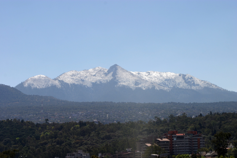
flickr.com -
Pico de Tancítaro, also known as Volcán Tancítaro, is a Mexican volcanic mountain. It is situated in the municipality of Tanctaro in the state of Michoacán. It is Michoacán's highest point.
Pico de Tancítaro is a stratovolcano with andesitic-dacitic magma. It was active between 800,000 and 237,000 years ago and is now thought to be extinct. It is part of the much larger volcanic field of Michoacán–Guanajuato. Some of the volcanic field is still active. Parícutin is a young volcano 11 kilometers northeast of Pico de Tancítaro. It erupted for the first time in 1943 and remained active and growing in size until 1952.
Pine-oak forest, open pine forest, and montane mesophyll or cloud forest are among the plant communities found on the mountain, with alpine grasslands known as Zacatonal found at higher elevations. The mountain is home to approximately 207 different animal species.
Pico de Tancítaro Flora and Fauna Protection Area spans 23,405 acres and ranges in elevation from 2,200 to 3,840 meters. On July 27, 1940, the area was designated as a national park, and on August 19, 2009, it was renamed a flora and fauna protection area. Pico de Tancítaro National Park is still widely known. Pico de Tancítaro and Parícutin are both included in the protected area.
Location: Tancítaro, Michoacán, Mexico
Elevation: 3,840 m (12,600 ft)
californiaavocadocomments.wordpress.com 
mapio.net


