


Top 8 Longest Rivers in Russia

Russia is separated into two parts: European and Asian. The Ural Mountains are widely regarded as the dividing line. The Arctic Ocean, Baltic Sea, Black Sea, ... read more...and Caspian Sea drain the European portion. The Asian portion of the lake drains into the Arctic and Pacific Oceans. Pechora, Volga, Don, Kama, Oka, and the Northern Dvina are notable Russian rivers in Europe, whereas the Dniepr and the Western Dvina start in Russia but flow into other nations. The Ob, the Irtysh, the Yenisei, the Angara, the Lena, the Amur, the Yana, the Indigirka, and the Kolyma are all prominent rivers in Asia. Today, Toplist brings to you 8 longest rivers in Russia.
-
The Lena is the easternmost of the three major rivers that run into the Arctic Ocean in Siberia (the other two being the Ob and the Yenisey). The majority of the catchment is covered in permafrost, with 77 percent of it being continuous. It stretches for 4,294 kilometers (2,668 miles) and drains 2,490,000 square kilometers (960,000 sq mi). The Lena is the world's eleventh-longest river and Russia's longest river entirely within its borders.
The Lena flows northeast through the Lena-Angara Plateau, joining the Kirenga, Vitim, and Olyokma at an elevation of 1,640 meters (5,381 feet) at its source in the Baikal Mountains south of the Central Siberian Plateau, 7 kilometers (4 miles) west of Lake Baikal. It runs north from Yakutsk into the Central Yakutian Lowland, where it is joined by the Aldan, its right-hand tributary, and the Vilyuy, its most important left-hand tributary. After that, it flows between the Kharaulakh Range (part of the Verkhoyansk Range) in the east and the Chekanovsky Ridge in the west, bending westward and northward. It expands into a vast delta as it travels north, eventually ending at the Laptev Sea, a split of the Arctic Ocean south-west of the New Siberian Islands. The Lena Delta covers 30,000 square kilometers (12,000 square miles) and is divided into seven main branches, the most important of which is the Bykovsky channel, which is located to the east.
The Lena river basin covers 2,490,000 square kilometers (960,000 square miles), with an average annual discharge of 489 cubic kilometers. Gold has been discovered in the Vitim and Olyokma sands, while mammoth tusks have been discovered in the delta.
Length: 4400 km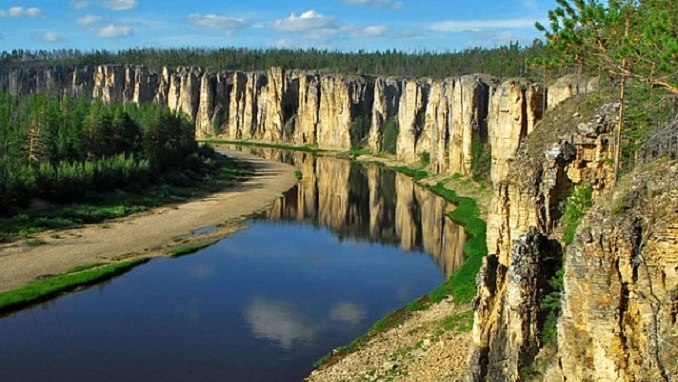
Photo: russiabusinesstoday 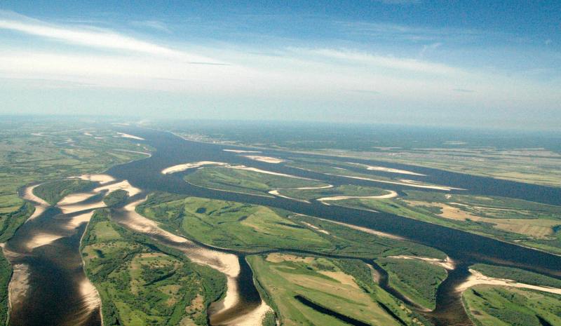
Photo: commons.wikimedia -
Irtysh is a river that flows through Russia, China, and Kazakhstan. It is the Ob's main tributary, as well as the world's longest tributary river. The river's source is in the Mongolian Altai, near the Mongolian border in Dzungaria (the northern portion of Xinjiang, China). The Tobol, Demyanka, and Ishim are three of the Irtysh's primary tributaries. Most of Western Siberia and the Altai Mountains are covered by the Ob-Irtysh system, which is Asia's largest drainage basin.
The Irtysh begins as the Kara-Irtysh in the Mongolian Altay highlands of Xinjiang, China, and runs northwest through Kazakhstan's Lake Zaysan, where it meets the Ishim and Tobol rivers before joining with the Ob near Khanty-Mansiysk in western Siberia, Russia (2,640 mi). Some authors, particularly in Russia and Kazakhstan, refer to the upper course of the river, from its source to Lake Zaysan, as the Black Irtysh. The phrase White Irtysh was once used to refer to the Irtysh below Lake Zaysan, in contrast to the Black Irtysh; however, this usage is now completely extinct.
During the ice-free season, which runs from April to October in Kazakhstan and Russia, tankers, passenger ships, and cargo ships navigate the river. Omsk is the largest river port in Western Siberia and is home to the state-owned Irtysh River Shipping Company's headquarters. There are three main hydroelectric plants on the Kazakhstan section of the river: Bukhtarma, Ust-Kamenogorsk, and Shulbinsk. With a drop of 42 meters (138 feet), the world's deepest lock allows river flow to bypass the dam at Ust-Kamenogorsk. There are plans in place to build several more dams.
Length: 4248 km
Photo: oddizzi Video: wikiwikiup -
The Ob is a large Russian river. It is located in western Siberia, and it forms the world's seventh-longest river system, with a total length of 5,410 kilometers, when combined with Irtysh (3,360 mi). It is formed by the meeting of the Biya and Katun rivers, both of which originate in the Altai Mountains. It is the westernmost of the three major rivers that flow into the Arctic Ocean in Siberia (the other two being the Yenisei and the Lena). It flows north-westward, then northward, before repeating these directions over a longer distance. The main city on its banks is Novosibirsk, the largest city in Siberia, and the third-largest city in Russia. It is where the Trans-Siberian Railway crosses the river. The Gulf of the Ob is the world's longest estuary.
Currently, the Ob River serves as a significant navigable canal, facilitating cargo transportation from Russia's interior to the country's major trade hubs and cities. This maritime channel is used to trade both agricultural and industrial items for import and export. The Ob River Basin is home to a huge number of Siberian oil and natural gas reserves, which produce two-thirds of the country's oil and natural gas. Numerous of the country's industrial centers, including as Novosibirsk and Barnaul, are located along the river's banks. Agriculture and animal ranching are major occupations in the river's diverse habitats' steppe zones. The Ob River Basin's fisheries are very well-developed, and Russian fishermen land significant quantities of edible fish captured from the Ob each year. The Ob River has the capacity to generate around 250 billion kilowatts of hydroelectric electricity. There are currently three hydroelectric projects on the Ob-Irtysh, one on the Ob at Novosibirsk and two on the Irtysh at Bukhtarma and skemen, respectively.
In the upper and middle courses of the river, extensive stretches of grassland and taiga plants make up the environment around the Ob River. Birches, pines, firs, and cedars are among the many trees that may be found in these places. Along the Ob River's stream, willow groves, wild rose bushes, and bird cherry trees flourish. More than 50 different species of fish, including sturgeons, carps, perches, nelmas, and peleds, can be found prospering in the river basin's waters. Around the Ob River, about 150 species of birds, including several migratory species, can be seen. Minks, wolves, Siberian moles, otters, beavers, and ermines are only a few of the ecosystem's native mammalian species.
Length: 3700 km
Photo: commons.wikimedia 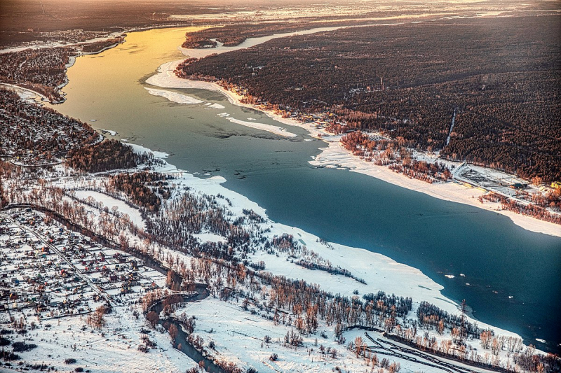
Photo: duhoctrungquoc. -
From its source to its outlet in the Caspian Sea, the Volga River is the world's 18th longest, stretching 3,530 kilometers. It is the world's longest river, running into the world's largest closed basin, the Caspian Sea. Its source, the Valdai Hills in Tver Oblast, is 228 meters above sea level, whereas the Caspian Sea is 28 meters below sea level.
By drainage basin and discharge, the Volga River is Europe's greatest river. Its drainage basin, which is nearly entirely in Russia, covers most of European Russia and houses the majority of the country's population, spanning 1.36 million square kilometers (the world's 15th largest drainage basin). The drainage basin is divided into four geographic zones; marshy forest, forest-steppe, steppe, and semidesert lowlands.
The Volga emits an average of 8,060 cubic meters of water each second, or around 250 cubic kilometers of water per year. The river does, however, have a maximum discharge of 48,500 cubic meters per second. The Oka, Sura, Kama, and Veltuga are among of the Volga's major tributaries. The Volga River delta is Europe's largest estuary, stretching 160 kilometers and containing over 500 minor rivers.
The Volga River Delta, located at the river's mouth, is a diverse habitat with 430 plant species, 127 fish species, 260 bird species, and 850 aquatic invertebrates, as well as a high number of insect species. The marshes of the Volga Delta are home to many migratory species, including Dalmatian pelicans and great white egrets. Sturgeons, Volga lampreys, whitefish, and herrings are among the fish species found in the river.
Length: 3530 km
Photo: britannica 
Photo: istockphoto -
The Yenisei River begins in Mongolia and runs north, draining a wide area of Siberia before entering the Kara Sea in the Arctic Ocean via the Yenisei Gulf. The Yenisei River starts near the Russian city of Kryzyl at the confluence of two headstreams, By-Khem (rising in the Eastern Sayan Mountains) and Ka-Khem (rising in Mongolia), and flows for 3,487 kilometers until it reaches the Kara Sea. The Angara River, which drains Lake Baikal, is one of the Yenisei's major headwater tributaries, joining the Yenisei near Strelka in Russia after leaving Lake Baikal. The Yenisei River has an average depth of 45 feet, and a drainage area of around 2,580,000 square kilometers.
For a vast portion of Russia's population, the Yenisei River provides their lifeline. Agriculture, cattle ranching, and fishing are some main professions of those who live along the river's route. Coal, copper, and nickel reserves are also exploited in specific places near the river basin, such as Norilsk. Lumber, petroleum products, coal, grains, and construction supplies are delivered between river ports along the Yenisei and Arctic oceans by cargo ships plying the river. On various portions of the river and its tributaries, a total of 25 million KW of hydroelectric power stations have been erected. The Sayano (pictured at the top of the article) and Krasnoyarsk are two of the largest power stations to have been built upon the Yenisei itself.
Around 55 native fish species can be found in the Yenisei River's waters. Some of the most notable native fish species in the Yenisei include Siberian sturgeons, Arctic flounders, Common roaches, Northern pikes, Siberian dungeons, tenches, and Sterlet sturgeons. Taiga flora covers a considerable portion of the Yenisei River Basin, which is dominated by coniferous trees like firs, cedars, spruces, and larches. Steppe grasslands can be found in several sections of the upper Yenisei River Basin.
Length: 3487 km
Photo: shootinfo 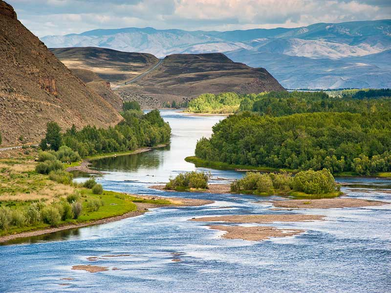
Photo: shootinfo -
The Nizhnyaya Tunguska is a Russian river that flows through Irkutsk Oblast and Krasnoyarsk Krai in Siberia. The river joins the Yenisey at Turukhansk and is a right tributary of the Yenisey. Tura, Yukti, and Simenga are among the river's settlements. The Nizhnyaya Tunguska's ice-free season begins in mid-June and lasts until the first half of October. The Lena Plateau's western boundary is formed by the river.
The Nizhnyaya Tunguska is the Yenisey's second-largest right tributary, and it joins it near Turukhansk. It stretches for 2,989 kilometers (1,857 miles) and drains 473,000 square kilometers (183,000 sq mi). The river can be divided into two sections based on the stream's characteristics, the valley's structure, and the river's shores: the first begins at the river's source and continues down to the village of Preobrazhenskoye, while the second section lies downstream of this village in a canyon-like relief.
The Nizhnyaya Tunguska channel and its tributaries form a dense network of rivers and creeks that provide easy summer paths through Eastern Siberia's broad rifted valley. The river has historically been used for the fur trade, fishing, and transportation of goods and mineral resources. The local economy still relies heavily on hunting and the fur trade.
Length: 2989 km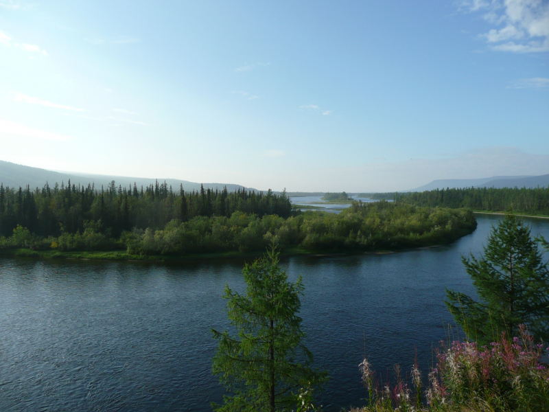
Photo: wikipedia Video: Century Old -
The Amur River, which forms the border between Russia's Far East and Northeastern China, is the world's tenth-longest river. The Amur River is 2,824 kilometers (1,755 miles) long, with a 1,855,000-square-kilometer drainage basin (716,000 sq mi). The kaluga is the largest fish species in the Amur, reaching lengths of up to 5.6 meters (18 ft). Northern snake head, Amur pike, taxmen, Amur catfish, predatory carp, and yellow cheek are among the large predatory fish found in the river basin, as are the northernmost populations of the Amur soft shell turtle and Indian lotus.
The Amur is thought to be home to at least 123 species of fish from 23 different families. The Gobioninae subfamily of Cypriniformes has the most members, followed by Salmonidae. A number of the species are indigenous to the area. The monotypic genera Pseudaspius and Mesocottus are exclusively found in the Amur and a few neighboring coastal rivers.
The kaluga, Amur sturgeon, Sakhalin sturgeon, and starlet are all members of the Acipenseridae family. The Kaluga and Amur sturgeons are endemic to their respective regions. In the 1950s, the starlet was introduced from the Ob.Length: 2824 km
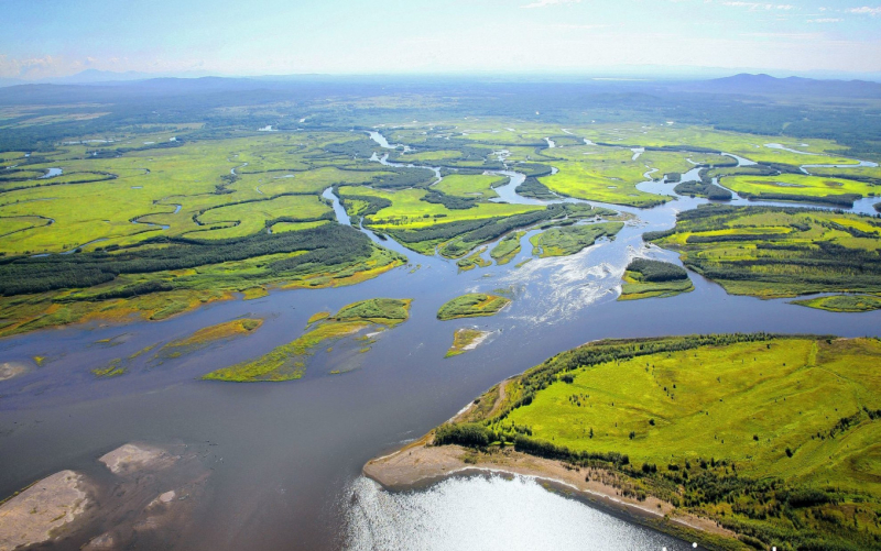
Photo: themoscowtimes Video: Kwik Facts -
The Vilyuy is a Russian river that is the Lena's longest tributary. It flows largely within the Sakha Republic and is 2,650 kilometers (1,650 miles) long. Its basin is 454,000 square kilometers in size (175,000 sq mi). The Vilyuy originates in the Vilyuy Plateau, which is a portion of the Central Siberian Plateau, in the Evenkiysky District (Krasnoyarsk Krai), and flows east into Sakha. In the Central Yakutian Lowland, it bends south and southeast, then east, and finally reaches the Lena about 350 kilometers (220 miles) downstream of Yakutsk, near Sangar. The Ust-Vilyuy Range rises above the Lena's facing bank, and across from the Vilyuy's mouth.
The Nizhnyaya Tunguska basin is located west of the Vilyuy and Chona rivers. The Vilyuy basin has a low population density. Vilyuysk, Verkhnevilyuysk, Suntar, and Nyurba are small settlements along the river. The Ulakhan-Vava, Chirkuo, Chona, Chybyda, Ulakhan-Botuobuya, Ochchuguy-Botuobuya, Tangnary, and Bappagay on the right, and the Akhtaranda, Ygyatta, Markha, Tyukyan, and Tyung on the left, are the primary tributaries of the Vilyuy.
Yakutsk-Vilyuy Rift (Vilyuy Rift Basin) and Yakutsk-Vilyuy LIP (large igneous province), sometimes known as Vilyuy Traps, are geological structures connected with Vilyuy.
Length: 2,650 km
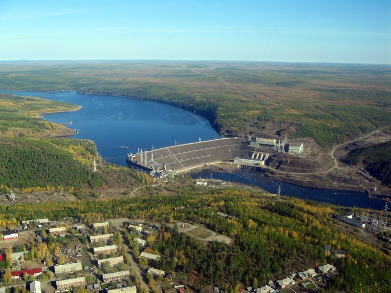
Photo: wikipedia Video: wikiwikiup


